File:MacedonEmpire.jpg
Jump to navigation
Jump to search

Size of this preview: 800 × 382 pixels. Other resolutions: 320 × 153 pixels | 640 × 306 pixels | 1,024 × 489 pixels | 1,990 × 951 pixels.
Original file (1,990 × 951 pixels, file size: 1.86 MB, MIME type: image/jpeg)
Captions
Captions
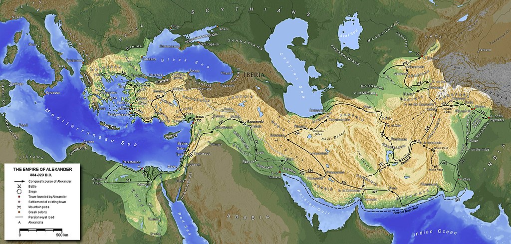
A map of Alexander the Great's empire at its largest extent c.323 BCE including details of key roads, location, and battles.
| Description |
English: Extent of the empire of Alexander the Great
Ελληνικά: Έκταση αυτοκρατορίας Μεγάλου Αλεξάνδρου
Español: Extensión del imperio de Alejandro Magno
Français : Etendue de l'empire d'Alexandre le Grand
Հայերեն: Ալեքսանդր Մակեդոնացու կայսրության քարտեզը
Македонски: Карта на древното Македонско Царство
Polski: Mapa Imperium Aleksandra Macedońskiego
Русский: Карта империи Александра Македонского
Türkçe: Büyük İskender'in genişlettiği imparatorluğu |
||||||||||
| Date | |||||||||||
| Source | Own work | ||||||||||
| Author | Generic Mapping Tools | ||||||||||
| Permission (Reusing this file) |
|
||||||||||
| Other versions |
Derivative works of this file:
|


File history
Click on a date/time to view the file as it appeared at that time.
| Date/Time | Thumbnail | Dimensions | User | Comment | |
|---|---|---|---|---|---|
| current | 16:26, 8 September 2020 | | 1,990 × 951 (1.86 MB) | Claude Zygiel (talk | contribs) | Shorelines of the hellenistic times |
| 12:26, 27 August 2016 |  | 1,990 × 951 (1.79 MB) | Ras67 (talk | contribs) | cropped | |
| 17:12, 29 January 2016 |  | 2,000 × 961 (1.87 MB) | Ercwlff (talk | contribs) | Reverted to version as of 19:39, 25 November 2012 (UTC) it's more important what wikipedia article says | |
| 11:25, 22 August 2015 |  | 2,000 × 961 (1.59 MB) | Հայկ Ափրիկյան (talk | contribs) | Armenia never was captured by Alexander the Great. Sources: *[http://penelope.uchicago.edu/Thayer/E/Roman/Texts/Strabo/11N*.html#ref24 Strabo, Geography: XI, 14. 9] *[https://archive.org/stream/cu31924026460752#page/n451/mode/2up Arrian, The Anabasis o... | |
| 19:39, 25 November 2012 |  | 2,000 × 961 (1.87 MB) | SilvioRusso (talk | contribs) | corr | |
| 17:33, 25 November 2012 |  | 2,000 × 961 (1.87 MB) | SilvioRusso (talk | contribs) | +Iberia | |
| 18:47, 13 April 2006 |  | 2,000 × 961 (806 KB) | Captain Blood~commonswiki (talk | contribs) | A. in Arachosia corr. | |
| 17:38, 24 March 2006 |  | 2,000 × 961 (806 KB) | Captain Blood~commonswiki (talk | contribs) | {{GFDL-GMT}} |
You cannot overwrite this file.
File usage
The following 32 pages use this file:
- Alexander the Great
- Atlas of Afghanistan
- Atlas of Armenia
- Atlas of Bulgaria
- Atlas of Cyprus
- Atlas of Egypt
- Atlas of Greece
- Atlas of Iran
- Atlas of Iraq
- Atlas of Iraqi Kurdistan
- Atlas of Israel
- Atlas of Kurdistan
- Atlas of Kuwait
- Atlas of Kyrgyzstan
- Atlas of Lebanon
- Atlas of Northern Cyprus
- Atlas of Pakistan
- Atlas of Palestine
- Atlas of Syria
- Atlas of Tajikistan
- Atlas of Turkey
- Atlas of Turkmenistan
- Atlas of Uzbekistan
- Atlas of Western Kurdistan
- Atlas of the Levant
- Atlas of the Macedonian Empire
- Jewish history
- User:Geagea/Israel/2015 August 22
- File:MacedonEmpire-2.jpg
- File:MacedonEmpire-fr.jpg
- File:Map-alexander-empire.png
- Category:GFDL-GMT
Global file usage
The following other wikis use this file:
- Usage on af.wikipedia.org
- Usage on am.wikipedia.org
- Usage on ar.wikipedia.org
- Usage on arz.wikipedia.org
- Usage on ast.wikipedia.org
- Usage on azb.wikipedia.org
- Usage on az.wikipedia.org
- Usage on ba.wikipedia.org
- Usage on be-tarask.wikipedia.org
- Usage on be.wikipedia.org
- Usage on bg.wikipedia.org
- Usage on br.wikipedia.org
- Usage on bs.wikipedia.org
- Usage on ca.wikipedia.org
- Usage on ce.wikipedia.org
- Usage on ckb.wikipedia.org
View more global usage of this file.