You don't need technical skills in order to contribute here. Be bold when contributing and assume good faith when interacting with others. This is a wiki.
@Joshua Jonathan: Yes, that's a good point. Are there any maps in either book that you would recommend using? I think there is a good map to use in this paper by Witzel on Vedic Dialects. There is one map resembling the Staal map I had previously used, where the line is vaguely said to mark "the natural boundaries of Vedic India", but from the second map (p.42)—which I previously had overlooked—it is clear that there are three categories that need to be demarcated:
1. the Kuru-Panchala area (fully Vedic, before 900 BCE)
2. the Kosala-Videha area at the intersection of Late Vedic and "Greater Magadha"/Shramanic cultures, where Late Vedic influence is shown by the presence of Vedic schools and patron kings who performed Vedic rituals (Witzel in his "Moving Targets" paper also observes the much greater proliferation of Brahmin villages in Kosala compared with Magadha in the Pali suttas that are thought to be early), but also criticized for having Eastern speech.
3. areas such as Magadha that were known to Late Vedic authors but were not Vedic, and considered off-limits for Brahmins until very late.
For the outermost dotted line in the current file, I see that it was actually added by Ms Sarah Welch, and seems to demarcate either the maximum geographical knowledge of the Deccan and/or the very late (post-Vedic Era?) migration of schools into the Deccan, but I don't know what source it comes from.
Samuel p.62? Nithing new there for you; you know the topic. Thanks in advance for willing to uodate the maps; it's quite essential, I think. The "Vedic period" and "Vedic culture" is commonly misunderstood as a monolithic bloc spanning the whole of northern India, gloryfying the accomplishments of the Vedas (the original meaning of which was lost with the rise of Hinduism...), and neglecting the existence of alternate Indo-Aryan tribes and cultures, and a plethora of local tarditions of whicj we know close to nothing. It's precisely this mix of cultures and traditions which led to Hinduism! Joshua Jonathan (talk) 07:47, 31 May 2020 (UTC)[reply]
Great! The maps you make are really awesome. One more suggestion: also show, with explanation, "greater Magadha" as a separate cultural sphere? Joshua Jonathan (talk) 04:28, 1 June 2020 (UTC)[reply]
@Avantiputra7 Is it possible to get the svg base file for these images? I need to generate a few images for a few wikipedia articles dealing with Ancient India, but can't find the base file you folks have been using. I appreciate your help. Varttik (talk) 20:00, 29 May 2022 (UTC)[reply]
Let me just start by saying that your maps are really amazing. However, recently I was reading the Mauryan Empire article where I saw your map contains names like 'Allahabad', 'Delhi', 'Taxila' these names were given to these cities much much later than the Mauryan Dynasty. There is a place which is a village near the modern city of Bodhan but is referred in map as Paudanyapura which is correct as that was it's Prakrit name in the Mauryan Dynasty. I think names must be uniform in the map, but I see that some are Prakrit some are Modern Day names. I didn't name all the cities but I can if you want. I am a big time cartophile and really like the map but the naming wasn't uniform so just didn't feel right, other than that the map seems good thank you for your time! --MindOfOm (talk) 03:59, 10 September 2022 (UTC)[reply]
Hello @MindOfOm: Thank you, I'm just now seeing this. It's not to say the modern day names of cities were around during the Maurya times, but for labelling edicts of Ashoka, the most common terms used by scholars today are "Delhi rock edict," "Allahabad pillar," etc. I couldn't think of a better way to label it all more uniformly. But am open to suggestions. -Avantiputra7 (talk) 09:34, 22 November 2023 (UTC)[reply]
Avantiputra7, I would like to bring to your attention a matter concerning the map you uploaded depicting the Maximum extent of the Maurya Empire on ( 20:00, 26 July 2014 ). I appreciate your neutrality in maintaining the map for the past six years. However, I have observed changes made to the map without any prior authority starting from the year 2020.
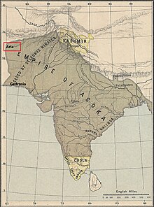
The specific concern revolves around the depiction of the provinces on the map. As you may be aware, the current map is utilized on the English Wikipedia, where it is captioned as "Maximum extent of the Maurya Empire, as shown by the location of Ashoka's inscriptions, and visualized by historians: Vincent Arthur Smith; R. C. Majumdar; and historical geographer Joseph E. Schwartzberg." The historians mentioned in the caption do not make any claims about the existence of a Gedrosia , Aria , Arachosia, Paropamisadae as unconquered region in the Maurya Empire.
Pg.75 : Chandragupta Maurya, and the four satrapies of Aria, Arachosia, Gedrosia, and the Paropanisadai were ceded to him by Seleukos Nikator about B.C. 305. The Maurya frontier was thus extended as far as the Hindû Kush Mountains, and the greater part of the countries now called Afghanistan, Balûchistan and Makran, with the North-Western Frontier Province, became incorporated in the Indian Empire. That empire included the famous strongholds of Kabul, Zabul, Kandahar, and Herat, and so possessed the scientific frontier' for which Anglo-Indian statesmen have long sighed in vain.
Pg.105 : Net result of the expedition, however, clearly indicate that Seleucus met with a miserable failure. For he had not only to finally abandon the idea of reconquering the Panjab, but had to buy peace by ceding Paropanisadai, Arachosia, and Aria, three rich provinces with the cities now known as Kabul, Kandähär and Herät respectively as their capitals, and also Gedrosia (Baluchistan), or at least a part of it. The victorious Maurya king probably married the daughter of his Greek rival, and made a present of five hundred elephants to his royl father-in-law.
Pg. 170 : By 311 B.C. or somewhat later the Indus had become the frontier of the Magadhan Empire. Further westward expansion was largely the outcome of the successful military encounter with Seleucus Nicator (Seleukos Nikator), founder of the Seleucid dynasty and inheritor of Alexander's eastern empire from northern Syria to India Between 305 and 302 B.C. Seleucus ceded the satrapies of Gedrosia. Arachosia, Paropamisadai, and probably Aria : gave his adversary a Greek princess in marriage, and obtained in return 500 war elephants and permanent peace and friendship on his eastern frontier. About this time, perhaps earlier, western Gandhara and areas north to the Hindu Kush, Abhisara, and probably Kasmira were also annexed to the Mauryan dominions.
Above I mentioned all three historian/geographer statement whose names are mentioned for using this map in en-wiki. So this map must follow them as it using their names in caption on en-wiki . Brother , I kindly request you to consider updating the map in accordance with the information provided in the English Wikipedia map caption. Please update the map by this one , I included all those four provinces: https://drive.google.com/file/d/1p72_rX7PQN2LGYJissw-sC3bRxRoDlcK/view?usp=drive_link
Hello @Antiidistorian: Please note that Gedrosia, Aria, Arachosia, Paropamisadae and Kalinga are the names of provinces, not of cities, and should not be marked in the same manner as cities, e.g. Tosali and Kandahar which are indicated already. Provinces, if they can be added without creating exessive clutter, should be labelled in a distinct font, and without dots like cities. That being said, please review the map of Joppen linked here, representing this view of older historians. The north-western borders stop just short of present-day Herat (capital of Aria), because, as Grainger says, the interpretation that Seleucids ceded Aria is based on a misinterpretation. I will not object to a map that replicates Joppen's boundaries faithfully and uses a better labelling for provinces. -Avantiputra7 (talk) 09:16, 22 November 2023 (UTC)[reply]
Hello @Avantiputra7 Indeed herat being under mauryans may was a miss interpretation, but if you are writing that this X was the map as per the Y historian, you have to include the opinion of that Y historian, even if he was wrong or had miss-interpreted, you still have to include his opinion because you clearly said that this X was the map as per Y historian, So even if Herat wasn't under Mauryans at all and was a miss interpretation, you still have to include herat because you are showing the map bassed on the opinion of Joseph E. Schwartzberg , Rc Majumdar and Vincient Arthur. They may were wrong regarding herat being under mauryans, But if you are showing the map from their prespective then please include herat. Because the shorter map which doesnt have kalinga and other territories already doesn't have herat so atleast include herat in the map of the empire from the prespective of Joseph E. Schwartzberg , Rc Majumdar and Vincient Arthur.
I have waited for 17 hours in your talk page for this issue. Since you are not replying at all. I shall wait for few more hours and if I don't get your reply, I will change the map back to 06:13, 22 November 2023 version since that's the map Which vincient arthur, Joseph and Rc Majumdar actually agree with. Indo12122 (talk) 19:54, 4 December 2023 (UTC)[reply]
@Avantiputra7 , I waited for like 2 days for your response. The new map has been designed with proper labeling, If you don't reply. I will consider that you are okay with the map we are going to post. Indo12122 (talk) 09:41, 5 December 2023 (UTC)[reply]
since you never responded. I have already considered that you are convinced and therefore we have uploaded the new map.
This time we headed to the talk section and tried our best to have discussions before uploading.
Hello@Avantiputra7 , sorry for not replying sooner. I've been really busy. My main concern is that the map should match the caption on the English Wikipedia. Otherwise, it might mislead people about what historians like Vincent Arthur Smith, R. C. Majumdar, and geographer Joseph E. Schwartzberg have visualized as the maximum extent of the Maurya Empire. The caption on Wikipedia says, "Maximum extent of the Maurya Empire, as shown by the location of Ashoka's inscriptions, and visualized by historians: Vincent Arthur Smith; R. C. Majumdar; and historical geographer Joseph E. Schwartzberg."
Your statement "I will not object to a map that replicates Joppen's boundaries faithfully and uses a better labelling for provinces." Okay , I understand your point about Joppen's boundaries but it seems that your map not aligning with Joppen's depiction accurately for northwestern , northeastern and south boundary . However, to maintain fidelity to the historical perspectives cited in the en-wiki caption, I suggest we prioritize the information provided by Smith, Majumdar, and Schwartzberg not others as historical perspectives may vary among historians. Antiidistorian (talk) 07:13, 6 December 2023 (UTC)[reply]
Edits to boundaries of my map File:Maurya_Empire,_c.250_BCE_2.png are okay as long they align with the reliable sources, but it must not be reverted to the old version from 2014 which is too inaccurate. Mostly, historians and reliable maps do not consider Assam as being a part of the empire (in contrast to Guptas who centuries later are known to have Kamarupa as a vassal kingdom), and also it is recorded that Drangiana province around present-day Hamun Lake on the Afghanistan-Iran border continued to be in the Seleucids' hands (as per [2]), so it is misleading to show those as in the old map. Joppen's map seems preferrable for getting such details right. Wherever Schwartzberg's map is clearly contradicted by other realiable sources I do not think we should blindly follow Schwartzberg's. Smith's map ([3]) is clipped off at the northwest so not really clear. (I don't have Majumdar's map at hand at present.) But really, though, the purpose of citing Smith, Majumdar, and Schwartzberg is not so much for disputes about external boundaries with Seleucids/northeast, but is more to illustrate the historical perspective that Mauryas controlled all of the interior land (in contrast to some scholars who are now conceptualizing a interior "holes" at the tribal/forest/desert parts). -Avantiputra7 (talk) 08:10, 15 December 2023 (UTC)[reply]
Thank you for your validation and prompt response. I completely agree with your statement : I will say, I like the labelling of the provinces in File:Mauryan_Empire_under_Ashoka.png. Edits to boundaries of my map File:Maurya_Empire,_c.250_BCE_2.png are okay as long they align with the reliable sources, but it must not be reverted to the old version from 2014 which is too inaccurate. and your further mention regarding Kamrupas . Moreover, I would like to emphasize that the current map not only aligns with Joppen's map but also corresponds with maps created by other reputable historians such as Geoffrey Parker :pg.29[4], Patrick K. O'Brien :Pg.46[5], Gerald Danzer Pg.44 :[6], and Charles Allen [7]. So, I think that our discussion has reached a conclusive decision to retain the current map and not to revert to 2014 version. Antiidistorian (talk) 19:31, 18 December 2023 (UTC)[reply]
File:Chandragupta Maurya and Bhadrabahu.png has been marked for speedy deletion. (Reason: Unauthorized usage, and lack of source . Wiki-common never encourage this type of cropping pasting work . It seems that user not given any souce and the user failed to provide proper attribution or information about the image's origin)
Why not upload a picture of a plant, animal, or anything else which fits into our scope. You can contribute any media type you want, including but not limited to images, videos, music, and 3D models. Start uploading now!
If you don't have anything to upload at the moment, why not take a look at our best images or best videos, sounds and 3D models. If you have any doubts/questions don't hesitate to visit our help desk.
User who nominated the file for deletion (Nominator) : Pinkish Flowers.
If you created this file, please note that the fact that it has been proposed for deletion does not necessarily mean that we do not value your kind contribution. It simply means that one person believes that there is some specific problem with it, such as a copyright issue. Please see Commons:But it's my own work! for a guide on how to address these issues.
Please remember to respond to and – if appropriate – contradict the arguments supporting deletion. Arguments which focus on the nominator will not affect the result of the nomination. Thank you!
Alignment with Joppen Map Boundaries in Recent Map Update[edit]
Hello @Avantiputra7,
I've noticed that you recently updated the map[8] and asserted that your changes align with Joppen's map. However, I would like to bring your attention that your map might not be strictly followed Joppen's boundary. It appears that the northwestern boundaries are not clearly identified by you. According to Joppen, he included the Aria region in this context.
Page 6-7 : " Seleukus, one of Alexander's generals, had made himself king of western and central Asia. But in 305 B.C. Chandragupta, after a successful campaign, forced him not only to give up all thought of conquest in India but also to cede the provinces of Parapamisadai, Aria, Arachosia, and probably Gedrosia (see maps 3 and 5). Thus the Hindu Kush mountains became the frontier of the first Indian Empire. Its capital was Pataliputra (now Patna). Chandragupta died in 297 B.C. and was succeeded by his son Bindusura (272 B.C.) and his grandson, the renowned Asoka (272-232).
Asoka's Empire extended in the north-west to the Hindu Kush, and included most of the territory now called Afghanistan, the greater part of Baluchistan, and all Sindh. Northwards his dominions stretched to the foot of the Himalayas and seem to have comprised the districts round Srinagar (which was built by him) and the territory round Lalita Patan in Nepal, two and a half miles south-east of Kathmandu (also built by him). The whole of Bengal acknowledged his sway, and the kingdom of Kalinga (i.e., the strip of country extending along the coast of the Bay of Bengal from the Mahanadi to the Godaveri) was subjugated in 261 B.C. The Dekkan had already been conquered either by Chandragupta or by Bindusura. The Andhra kingdom, between the Godaveri and the Kistna, was administered by its own raja, but seems to have been a protected state. The southern frontier of the empire must have coincided closely with the 13th degree of northern latitude. The southern Tamil kingdoms of Chola, Pandya, Satiya, and Chera remained independent."
Hello @Antiidistorian: , how so? The label of Aria here has been placed at the location of present-day Herat (coordinates: 34°20′31″N 62°12′11″E), which if you check it against the grid of coordinates on Joppen's map falls just outside of the enclosed shaded area. What should be changed and how much can the label accurately be moved? -Avantiputra7 (talk) 03:50, 4 February 2024 (UTC)[reply]
There might have been a misinterpretation regarding the map by you. According to Joppen, Aria was indeed included on the map. This assertion is given by his book, specifically on pages 6 and 7, where he details the process of creating the map in accordance with his statements.
Page 6-7 : " Seleukus, one of Alexander's generals, had made himself king of western and central Asia. But in 305 B.C. Chandragupta, after a successful campaign, forced him not only to give up all thought of conquest in India but also to cede the provinces of Parapamisadai, Aria, Arachosia, and probably Gedrosia (see maps 3 and 5). Thus the Hindu Kush mountains became the frontier of the first Indian Empire. Its capital was Pataliputra (now Patna). Chandragupta died in 297 B.C. and was succeeded by his son Bindusura (272 B.C.) and his grandson, the renowned Asoka (272-232)."[10]
It evident that the bulging part represents Aria. As per Charles Joppen's description of the Ashoka Empire, the bulging part on the map represents Aria.
Hello @Antiidistorian: then there may be a contradiction or ambiguity present when comparing the text to the map, because I actually checked it and the farthest corner of this bulge goes up to approximately 33°20′N 62°30′E, so that it appears to be including Farah, Afghanistan (anciently "being an intermediate stop between Alexandria Arachosia (modern Kandahar) and Herat") but not Herat itself, as you can check yourself by plotting it at 34°20′31″N 62°12′11″E. In any case, it would moreover be misleading to viewers for the map to include Herat seeing as more recent research has proven that it definitely remained Seleucid territory, as per the following:
"The region of Aria is definitely known to have been Seleucid under Seleucus I and Antiochus I as it definitely was after Antiochus III's great campaign in the east against the Parthians and Bactrians. [...] There is no evidence whatever that it did not remain Seleucid, like Drangiana, with which it is linked by easy routes." -Susan M. Sherwin-White and Amélie Kuhrt (1993) From Samarkhand to Sardis: A New Approach to the Seleucid Empire, University of California Press, pp.79-80
Cities founded by Antiochus I between 281-261 BCE include "Soteria in Aria (region of Herat)" -Oxford Classical Dictionary, Fourth ed. (Oxford University Press, 2012), p.104
Hello @Avantiputra7, Since you have claimed about aligning the map according to Joppen's boundaries, it should adhere strictly to his delineations. You are referencing additional work to assert that Aria belonged to the Seleucid Empire seems unnecessary, as interpretations vary among scholars, with the majority indicating Aria's association with the Mauryans. Previously, we discussed aligning this standard map with its caption on the English Wikipedia : "Maximum extent of the Maurya Empire, as shown by the location of Ashoka's inscriptions, and visualized by historians: Vincent Arthur Smith; R. C. Majumdar; and historical geographer Joseph E. Schwartzberg."
Pg.75 : Chandragupta Maurya, and the four satrapies of Aria, Arachosia, Gedrosia, and the Paropanisadai were ceded to him by Seleukos Nikator about B.C. 305. The Maurya frontier was thus extended as far as the Hindû Kush Mountains, and the greater part of the countries now called Afghanistan, Balûchistan and Makran, with the North-Western Frontier Province, became incorporated in the Indian Empire. That empire included the famous strongholds of Kabul, Zabul, Kandahar, and Herat, and so possessed the scientific frontier' for which Anglo-Indian statesmen have long sighed in vain.
Asoka, the Buddhist emperor of India by Smith, Vincent Arthur [13]
Pg.105 : Net result of the expedition, however, clearly indicate that Seleucus met with a miserable failure. For he had not only to finally abandon the idea of reconquering the Panjab, but had to buy peace by ceding Paropanisadai, Arachosia, and Aria, three rich provinces with the cities now known as Kabul, Kandähär and Herät respectively as their capitals, and also Gedrosia (Baluchistan), or at least a part of it. The victorious Maurya king probably married the daughter of his Greek rival, and made a present of five hundred elephants to his royl father-in-law.
Pg. 170 : By 311 B.C. or somewhat later the Indus had become the frontier of the Magadhan Empire. Further westward expansion was largely the outcome of the successful military encounter with Seleucus Nicator (Seleukos Nikator), founder of the Seleucid dynasty and inheritor of Alexander's eastern empire from northern Syria to India Between 305 and 302 B.C. Seleucus ceded the satrapies of Gedrosia. Arachosia, Paropamisadai, and probably Aria , gave his adversary a Greek princess in marriage, and obtained in return 500 war elephants and permanent peace and friendship on his eastern frontier. About this time, perhaps earlier, western Gandhara and areas north to the Hindu Kush, Abhisara, and probably Kasmira were also annexed to the Mauryan dominions.
Historical Atlas of India by Joseph E. Schwartzberg [15]
Pg.33 : The ancient historians Justin, Appian, and Strabo preserve the three main terms of what I will call the Treaty of the Indus: (i) Seleucus transferred to Chandragupta's kingdom the easternmost satrapies of his empire, certainly Gandhara, Parapamisadae, and the eastern parts of Gedrosia, and possibly also Arachosia and Aria as far as Herat. (ii) Chandragupta gave Seleucus 500 Indian war elephants. (iii) The two kings were joined by some kind of marriage alliance (ἐπιγαμία οι κῆδος); most likely Chandragupta wed a female relative of Seleucus.
The Land of the Elephant Kings by Paul J Kosmin [16]
Pg. 15 : Towards the north-west, his empire marched with that of the Syrian monarch, Antiochos [R.E. II], and hence extended up to Persia and Syria which were held by Antiochos, while it is also known how Asoka's grandfather, Chandragupta, had wrested from Selukos the provinces of Aria, Arachosia, Paropanisadai and Gedrosia, which descended to Asoka as his inheritance. Lastly, the extent of his empire is also indicated by his own mention in the Edicts (Rock Edict II, V, and XIII] of the peoples on its borders In the south, these are mentioned as the Cholas, Pandyas, the Satiyaputra and Keralaputra, who were all within his sphere of influence Towards the north-west, his empire marched with that of the Syrian monarch, Antiochos [Rock Edict II], and hence extended up to Persia and Syria which were held by Antiochos, while it is also known how Asoka's grandfather, Chandragupta, had wrested from Selukos the provinces of Aria, Arachosia, Paropanisadai and Gedrosia, which descended to Asoka as his inheritance .
Therefore, for the sake of maintaining standardization in the map, it is advisable to adhere strictly to Joppen's delineations without incorporating alternative interpretations. For instance, some WikiCommons users have created a western boundary on Joppen's work and included Aria.
Apart from this , ongoing with primary account , Greek geographer and historian Strabo & Pliny, the Seleucus ceded four territories to Chandragupta:
The geographical position of the tribes is as follows: along the Indus are the Paropamisadae, above whom lies the Paropamisus mountain: then, towards the south, the Arachoti (Arachosia): then next, towards the south, the Gedroseni (Gedrosia), with the other tribes that occupy the seaboard; and the Indus lies, latitudinally, alongside all these places; and of these places, in part, some that lie along the Indus are held by Indians, although they formerly belonged to the Persians. Alexander [III 'the Great' of Macedon] took these away from the Arians and established settlements of his own, but Seleucus Nicator gave them to Sandrocottus , upon terms of intermarriage and of receiving in exchange five hundred elephants. Alongside the Paropamisadae, on the west, are situated the Arii, and alongside the Arochoti and Gedrosii the Drangae; but the Arii are situated alongside the Drangae on the north as well as on the west, almost surrounding a small part of their country. Bactriana lies to the north alongside both Aria and the Paropamisadae.
He also illustrates that all these four provinces combinedly called Ariana :
Ariana is bounded on the east by the Indus River, on the south by the great sea, on the north by the Paropamisus mountain and the mountains that follow it as far as the Caspian Gates, and that its parts on the west are marked by the same boundaries by which Parthia is separated from Media and Carmania from Paraetacené and Persis.
Most geographers, in fact, do not look upon India as bounded by the river Indus, but add to it the four satrapies of the Gedrose (Gedrosia), the Arachotë (Arachosia), the Aria , and the Paropamisadë , the River Cophes(Kabul River) thus forming the extreme boundary of India.
Hello @Antiidistorian: please note that the current map boundary already aligns with Joppen's map, with the farthest corner of the "bulge" going up to approximately 33°20′N 62°30′E. The label of Aria has simply been placed at the location of Herat, 34°20′31″N 62°12′11″E. I'm not seeing what needs to be changed. (It seems that in the wiki map by Cattette the label of Aria is farther south than the main part of Aria which was actually around the label "Alexandria in Ariana.") -Avantiputra7 (talk) 14:27, 17 February 2024 (UTC)[reply]
Hello Avantiputra7. I wanted to talk to you first in lieu of directly reverting the map to the previous one. I read the recent message between you and Antiidistorian. I’ve noticed a few problems with the map but the main problem is that the Joppen map includes details such as bays and areas which outlines the borders of the empire, and it shows the western coastal border ending exactly at (25.1720682, 61.6679502) in a bay called “Jiwani Bay” if you look up the coordinates… it would be great if you could fix that mistake…. Thank you. (Discopleasant (talk) 01:19, 19 April 2024 (UTC))[reply]
India in 250 BCE Joppen
Just to be clear, this is the image the current full map is based on and it's extending into what's now Jiwani bay. Should we replace the current full map with the original Joppen map? it seems like the most accurate depiction. (Discopleasant (talk) 09:59, 26 April 2024 (UTC))[reply]
Hello @Discopleasant: see the latest, tweaked upload of the map. Personally, I would have no objection to replacing the second map on the Wikipedia page with Joppen's map. However, please keep in mind that all conjectures about the western boundaries are inherently totally speculative, because the ancient historical writings do not specify the extent, and there is no concrete archaeological evidence whatsoever of Mauryans in Balochistan. -Avantiputra7 (talk) 11:07, 30 April 2024 (UTC)[reply]
Hi Avantiputra7, thank you for your reply and the latest version of the map. And regarding the Mauryan presence in Balochistan, there are indeed references that specify Mauryan domination in the Makran area, which is the coastal area between Iran and Pakistan and coincides with Balochistan. Again, thank you for your edits and reply. (Discopleasant (talk) 00:26, 1 May 2024 (UTC))[reply]

.png)


 Therefore, for the sake of maintaining standardization in the map, it is advisable to adhere strictly to Joppen's delineations


.png)
![[8]](https://commons.wikimedia.org/wiki/File:Maurya_Empire,_c.250_BCE_2.png)
![[9]](https://commons.m.wikimedia.org/wiki/File:India_in_250_BCE_Joppen.jpg)
