Category:Derbyshire
Vai alla navigazione
Vai alla ricerca

Contee cerimoniale dell’Inghilterra: Bedfordshire · Berkshire · Buckinghamshire · Cambridgeshire · Cheshire · Cornwall · Cumbria · Derbyshire · Devon · Dorset · Durham · East Riding of Yorkshire · East Sussex · Essex · Gloucestershire · Greater London · Greater Manchester · Hampshire · Herefordshire · Hertfordshire · Isle of Wight · Kent · Lancashire · Leicestershire · Lincolnshire · Merseyside · Norfolk · North Yorkshire · Northamptonshire · Northumberland · Nottinghamshire · Oxfordshire · Rutland · Shropshire · Somerset · South Yorkshire · Staffordshire · Suffolk · Surrey · Tyne and Wear · Warwickshire · West Midlands · West Sussex · West Yorkshire · Wiltshire · Worcestershire
City-counties: Bristol · City of London
Contee tradizionali: Cumberland · Huntingdonshire · London · Middlesex · North Riding of Yorkshire · Sussex · West Riding of Yorkshire · Westmorland · Yorkshire
Other former counties: Avon · Cambridgeshire and Isle of Ely · Cleveland · East Suffolk · Hereford and Worcester · Hexhamshire · Humberside · Huntingdon and Peterborough · Isle of Ely · Parts of Holland · Parts of Kesteven · Parts of Lindsey · Soke of Peterborough · West Suffolk
contea inglese  Matlock County Hall     | |||||
| Carica un file multimediale | |||||
| Istanza di |
| ||||
|---|---|---|---|---|---|
| Luogo |
| ||||
| Capitale | |||||
| Popolazione |
| ||||
| Superficie |
| ||||
| Distinto da | |||||
| Considerato essere uguale a | Derbyshire (contea tradizionale dell'Inghilterra, contea cerimoniale, 1844) | ||||
| sito web ufficiale | |||||
 | |||||
Sottocategorie
Questa categoria contiene le 45 sottocategorie indicate di seguito, su un totale di 45.
*
- Valued images of Derbyshire (3 F)
A
B
- Boundary stones in Derbyshire (48 F)
C
- Campsites in Derbyshire (22 F)
- Carved trees in Derbyshire (4 F)
D
- Earthworks in Derbyshire (6 F)
E
F
G
- Gallery pages of Derbyshire (7 P)
H
I
M
- Morris dance in Derbyshire (12 F)
N
P
- Derbyshire on photochrome prints (61 F)
Q
- Quality images of Derbyshire (127 F)
S
- Sepia photographs of Derbyshire (17 F)
T
U
V
- Videos from Derbyshire (2 F)
Pagine nella categoria "Derbyshire"
Questa categoria contiene un'unica pagina, indicata di seguito.
File nella categoria "Derbyshire"
Questa categoria contiene 200 file, indicati di seguito, su un totale di 301.
(pagina precedente) (pagina successiva)-
 2021 Derbyshire County Council diagram.svg 360 × 185; 4 KB
-
 A walk in the park (6318918542).jpg 3 056 × 4 592; 7,04 MB
-
 All about Derbyshire (IA allaboutderbyshi00brad).pdf 672 × 1 058, 472 pagine; 23,75 MB
-
 Bolehill Quarry (26731441240).jpg 6 867 × 4 578; 18,34 MB
-
 Derbyshire UK location CurbarEdge Location Map.jpg 1 320 × 1 949; 559 KB
-
En-derbyshire.ogg 2,1 s; 25 KB
-
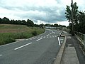
 Entering South Derbyshire - geograph.org.uk - 915551.jpg 640 × 404; 81 KB
-
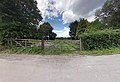
 Entrance to Carpenter's - geograph.org.uk - 2154244.jpg 1 024 × 683; 181 KB
-
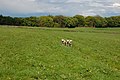
 Erewash Field a Nature Reserve - geograph.org.uk - 1091269.jpg 640 × 480; 164 KB
-
 Ex Reef. (25363913063).jpg 6 032 × 3 964; 23,9 MB
-
-
 Farmhouse near Tapton - geograph.org.uk - 966343.jpg 640 × 420; 119 KB
-
 Fenced off pond - geograph.org.uk - 2304635.jpg 1 897 × 1 387; 707 KB
-
 Firepump, Springfield Mill - geograph.org.uk - 1585668.jpg 420 × 640; 79 KB
-
 Fiveways Crossing on A515, London Road, Buxton - geograph.org.uk - 3073483.jpg 4 000 × 2 257; 1,46 MB
-

-

-
 Footpath beside Buxton Rail Station - geograph.org.uk - 2535567.jpg 640 × 480; 175 KB
-
 Footpath crossing Dinting Road - geograph.org.uk - 2477938.jpg 1 600 × 1 200; 424 KB
-

-
 Footpath renovation - geograph.org.uk - 2309051.jpg 2 048 × 1 536; 803 KB
-
 Footpath south wingfield under railway.jpg 4 912 × 3 264; 2,96 MB
-
 Footpath through High Plantation near Buxton - geograph.org.uk - 2648250.jpg 3 000 × 4 000; 3,03 MB
-
-
 Gate hope valley - panoramio.jpg 6 158 × 4 218; 6,76 MB
-
 Gate into Cavendish Golf Club - geograph.org.uk - 3126280.jpg 3 872 × 2 592; 4,53 MB
-
 Gate to the woods - geograph.org.uk - 2304718.jpg 1 997 × 1 497; 784 KB
-
 Gatepost with benchmark - geograph.org.uk - 785818.jpg 640 × 480; 94 KB
-
 Gotham Granges from High Peak Trail - geograph.org.uk - 1613829.jpg 640 × 480; 73 KB
-
 Grassmoor - Birkin Lane - geograph.org.uk - 836842.jpg 640 × 480; 91 KB
-
 Gravel pit off pasture Lane - geograph.org.uk - 1090667.jpg 640 × 480; 133 KB
-
 Green Lane - geograph.org.uk - 1003050.jpg 640 × 480; 109 KB
-
 Green Lane - geograph.org.uk - 792073.jpg 640 × 480; 82 KB
-
 Green pastures - geograph.org.uk - 1734037.jpg 1 024 × 768; 156 KB
-
 Gritting lorries at rest - geograph.org.uk - 1625785.jpg 640 × 480; 160 KB
-
 Hague Street - geograph.org.uk - 3173454.jpg 640 × 481; 603 KB
-
 Hardybarn Lane with some more snow - geograph.org.uk - 1715511.jpg 640 × 480; 99 KB
-
 Heading North on the Midshires Way to Oldfield - geograph.org.uk - 1780722.jpg 2 304 × 3 072; 2,99 MB
-
 Heanor gate school classrooms.jpg 3 264 × 2 448; 2,6 MB
-
 HeanorGateScienceCollege2020.jpg 3 992 × 2 395; 7,17 MB
-

-
 Herbie Goes Hiking (25722581667).png 3 648 × 4 864; 17,09 MB
-
 High Stones - geograph.org.uk - 989835.jpg 300 × 225; 11 KB
-
-
 Hills of the Peak District.jpg 774 × 774; 100 KB
-
 Holmewood and Five Pits Trail - geograph.org.uk - 1253943.jpg 640 × 480; 103 KB
-
 Horse looking at photographer - geograph.org.uk - 1730762.jpg 640 × 480; 120 KB
-

-
 Houses in the fog - geograph.org.uk - 1620114.jpg 640 × 480; 71 KB
-
 Houses on the Hill (17069158837).jpg 4 608 × 2 592; 4,64 MB
-
 Howden Dean - geograph.org.uk - 1700585.jpg 480 × 640; 51 KB
-
 Howden Edge at High Stones - geograph.org.uk - 1445207.jpg 640 × 480; 137 KB
-
 Howden Edge towards Howden Clough - geograph.org.uk - 1445199.jpg 640 × 480; 135 KB
-

-
 Icicles - geograph.org.uk - 1633589.jpg 480 × 640; 69 KB
-
 If you like mud ... - geograph.org.uk - 1311134.jpg 640 × 425; 69 KB
-
 In the ancient wood (548853250).jpg 1 600 × 1 199; 669 KB
-

-
 Into the woods - geograph.org.uk - 2312844.jpg 1 805 × 1 369; 313 KB
-
 Iron Age Hut, plaque set in stone - geograph.org.uk - 1077605.jpg 640 × 480; 161 KB
-
 Isolated Beauty (Unsplash).jpg 3 456 × 5 184; 11,17 MB
-
 Jack by the Hedge - geograph.org.uk - 1306588.jpg 479 × 640; 220 KB
-
 Johnson's Knoll - geograph.org.uk - 1310993.jpg 640 × 425; 58 KB
-
 Jon Eno - BEM.jpg 1 620 × 1 491; 135 KB
-
 Junction at the top of the quarry - geograph.org.uk - 2303541.jpg 2 048 × 1 536; 870 KB
-

-
 Just a glimpse - Flickr - Chris Morriss.jpg 3 776 × 2 520; 732 KB
-
 Kiln Stacking - geograph.org.uk - 959449.jpg 640 × 480; 71 KB
-
 L and N W Ry Co Boundary Post - geograph.org.uk - 1613809.jpg 480 × 640; 83 KB
-

-
 LeaDerb.JPG 3 072 × 2 304; 3,7 MB
-
 Lees Hall - geograph.org.uk - 3173448.jpg 640 × 853; 1,08 MB
-
 Lees Hall - geograph.org.uk - 3173484.jpg 640 × 481; 720 KB
-

-
 Loading point - geograph.org.uk - 1409571.jpg 640 × 426; 124 KB
-
 Long Clough Brook - geograph.org.uk - 3173496.jpg 640 × 480; 638 KB
-
 Long Hill - geograph.org.uk - 1815611.jpg 2 816 × 2 112; 1,34 MB
-
 Longdendale cycle trail - geograph.org.uk - 1172844.jpg 640 × 437; 98 KB
-
 Longdendale Trail near Deepclough - geograph.org.uk - 949910.jpg 640 × 480; 146 KB
-

-
 Looking North up the Midshires Way - geograph.org.uk - 1778585.jpg 2 304 × 3 072; 3,24 MB
-
 Looking south on Abney Moor - geograph.org.uk - 1596637.jpg 640 × 445; 57 KB
-
 Looking towards Griffe Grange - geograph.org.uk - 1625768.jpg 640 × 480; 93 KB
-
 Lower Garden - geograph.org.uk - 790830.jpg 640 × 480; 115 KB
-
 Lowfoot Farm ^ Fairfield Low - geograph.org.uk - 2013414.jpg 3 888 × 2 592; 4,9 MB
-
 Macclesfield Old Road on the Outskirts of Buxton - geograph.org.uk - 3012104.jpg 3 296 × 2 472; 1,09 MB
-
 Macclesfield Old road, Burbage - geograph.org.uk - 2946922.jpg 1 280 × 853; 356 KB
-
 Manifold Farm (33370616308).jpg 2 048 × 1 536; 874 KB
-
 Manifold Farm (47194296732).jpg 2 048 × 1 346; 924 KB
-
 Manifold Farm (47194353542).jpg 2 048 × 1 343; 749 KB
-
 Middle Hills Farm - geograph.org.uk - 780218.jpg 640 × 480; 80 KB
-
 Milltown and Ravennest Tor.jpg 2 048 × 1 536; 725 KB
-
 Minor Lane to Leap Edge - geograph.org.uk - 3036270.jpg 3 296 × 2 472; 1,34 MB
-
 Minor Road at Leap Edge - geograph.org.uk - 3036279.jpg 3 296 × 2 472; 1,03 MB
-
 Minor road under the High Peak Trail - geograph.org.uk - 1772828.jpg 640 × 480; 74 KB
-
 Morrisons, Buxton - geograph.org.uk - 1864005.jpg 640 × 584; 110 KB
-
-
 Mown Field and Midshires Way - geograph.org.uk - 860315.jpg 640 × 427; 197 KB
-
 My Goal is the Stile - geograph.org.uk - 1293745.jpg 640 × 427; 139 KB
-
 National Forest Sign, Midlands, UK.jpg 1 536 × 2 048; 887 KB
-
 National Trust Collection Box - geograph.org.uk - 1572501.jpg 640 × 480; 100 KB
-
 Near Hathersage, Peak District 8 (cropped, edited).jpg 3 888 × 1 901; 2,78 MB
-
 New shelterbelt plantation - geograph.org.uk - 785786.jpg 640 × 480; 111 KB
-
 New track on Erewash Field - geograph.org.uk - 1091265.jpg 640 × 480; 173 KB
-
 Newshaw Lane, Brookfield - geograph.org.uk - 3216431.jpg 640 × 481; 537 KB
-
-
 No swimming - geograph.org.uk - 1603478.jpg 640 × 480; 64 KB
-
 Norman Frost of New Street Stanley with one of the first Felix Buses.jpg 1 390 × 1 390; 200 KB
-
 Oakerthorpe-SouthWingfield.jpg 5 472 × 3 648; 4,38 MB
-
 Oaktree oakerthorpe.jpg 2 154 × 2 897; 1,78 MB
-
 Oat Field and Iron Works - geograph.org.uk - 918000.jpg 427 × 640; 227 KB
-
 Odd cypresses - geograph.org.uk - 1357356.jpg 479 × 640; 81 KB
-
 Old gardens - geograph.org.uk - 775575.jpg 640 × 480; 169 KB
-
 Old industrial units by the road to Grin Low - geograph.org.uk - 3124268.jpg 3 872 × 2 592; 3,97 MB
-
 Old orchard - geograph.org.uk - 1564175.jpg 640 × 480; 129 KB
-
 Old Parcel Force Trailer - geograph.org.uk - 1072803.jpg 414 × 640; 89 KB
-
 Old stone base - geograph.org.uk - 792083.jpg 640 × 480; 104 KB
-
 Old stone gateposts - geograph.org.uk - 2303591.jpg 1 888 × 1 361; 575 KB
-
 Old stone wall - geograph.org.uk - 647557.jpg 640 × 480; 123 KB
-
 Old strainer post - geograph.org.uk - 2312885.jpg 1 370 × 1 904; 869 KB
-
 On a green lane past Rockfield House - geograph.org.uk - 1759781.jpg 640 × 480; 70 KB
-
 On a path towards Tissington - geograph.org.uk - 1634546.jpg 640 × 480; 59 KB
-

-
 Open access area off the High Peak Trail - geograph.org.uk - 1230236.jpg 640 × 480; 111 KB
-
 Orange-tip at Woodcote - geograph.org.uk - 816189.jpg 640 × 636; 104 KB
-
 Oranges and lemons - geograph.org.uk - 1451112.jpg 640 × 447; 172 KB
-
 Ornate chair in St John the Baptist Church of England church in Tideswell.jpg 3 024 × 4 032; 3,74 MB
-
 Over Owler Tor - panoramio - PJMarriott.jpg 3 072 × 2 304; 1,5 MB
-
 Over Owler Tor - panoramio.jpg 3 072 × 2 304; 1,42 MB
-
 Overlooking Alport Valley past trees - panoramio.jpg 8 447 × 2 329; 4,76 MB
-
 Overlooking Buxton from the edge of the High Plantation - geograph.org.uk - 2763660.jpg 3 218 × 2 364; 1,24 MB
-

-
 Path across playing fields to Buxton - geograph.org.uk - 3133899.jpg 3 872 × 2 592; 5,1 MB
-
 Path leading off Erewash Field - geograph.org.uk - 1091278.jpg 640 × 480; 185 KB
-
 Path or Stream? - geograph.org.uk - 645103.jpg 427 × 640; 155 KB
-
 Path through Peat Pits - geograph.org.uk - 647534.jpg 640 × 480; 130 KB
-
 Path to a Gravel Pit - geograph.org.uk - 1090651.jpg 640 × 480; 164 KB
-
 Path to the Country Park - panoramio.jpg 1 600 × 1 200; 342 KB
-
 Peaking emotion (Unsplash).jpg 5 184 × 3 456; 10,46 MB
-
 Peat Pits - geograph.org.uk - 647530.jpg 640 × 480; 119 KB
-
 Pennytown ponds somercotes.jpg 5 472 × 3 648; 4,97 MB
-
-
 Plant storage near Watford Farm - geograph.org.uk - 3126261.jpg 3 872 × 2 592; 5,23 MB
-
 Playground and Wind Turbine near Visitor Centre - panoramio.jpg 1 600 × 1 200; 362 KB
-
 Polytunnels at Park Style Farm - geograph.org.uk - 1240995.jpg 640 × 480; 49 KB
-
 Pond and barn on a foggy morning - geograph.org.uk - 1620129.jpg 640 × 480; 54 KB
-
 Private pond - geograph.org.uk - 647607.jpg 640 × 480; 117 KB
-
 Private Road Overlooking Plex Lodge - geograph.org.uk - 3012090.jpg 3 140 × 2 250; 1,53 MB
-
 Public art vandalised - geograph.org.uk - 1184130.jpg 640 × 480; 123 KB
-

-
 Railway line seen from bridge - geograph.org.uk - 2999287.jpg 640 × 482; 120 KB
-
 Rake Lane - Entering Middleton - geograph.org.uk - 1010225.jpg 640 × 480; 93 KB
-
 Redhouse Farm - geograph.org.uk - 944368.jpg 640 × 480; 78 KB
-
 Redundant farming machinery - geograph.org.uk - 1759309.jpg 640 × 480; 92 KB
-
 Reservoir with island - geograph.org.uk - 1440954.jpg 640 × 480; 70 KB
-
 Reservoir, Dinting Vale - geograph.org.uk - 3173267.jpg 640 × 481; 497 KB
-
 Rippling shadows - geograph.org.uk - 1451116.jpg 640 × 479; 103 KB
-
 Risley Coppice - geograph.org.uk - 1303457.jpg 427 × 640; 156 KB
-
 River Wye - geograph.org.uk - 1815867.jpg 2 816 × 2 112; 1,93 MB
-
 Riverside Path Seating Area - geograph.org.uk - 1058545.jpg 640 × 426; 138 KB
-
 Road junction at Ladmanlow - geograph.org.uk - 3124253.jpg 3 872 × 2 592; 5,42 MB
-
 Robert Marsden 2019.jpg 1 200 × 1 200; 471 KB
-
 Rocky road to hayfield.jpg 683 × 1 024; 219 KB
-

-
 Rye Croft Barn - panoramio.jpg 5 376 × 3 024; 6,27 MB
-
 Scots Pine on Shipley Hill - panoramio.jpg 1 200 × 1 600; 503 KB
-
 Seat and footpath junction - geograph.org.uk - 647570.jpg 640 × 480; 119 KB
-
 Seat with a view - geograph.org.uk - 2309129.jpg 1 912 × 1 434; 463 KB
-
 Sedge warbler - geograph.org.uk - 1357851.jpg 640 × 480; 143 KB
-
 Sewage Beds - geograph.org.uk - 783842.jpg 640 × 480; 114 KB
-
 Shaw Lane - geograph.org.uk - 2111549.jpg 3 676 × 2 489; 3,08 MB
-
 Shaw Lane, Brookfield - geograph.org.uk - 3216425.jpg 640 × 481; 530 KB
-
 Shaw's Farm - geograph.org.uk - 1634629.jpg 640 × 480; 112 KB
-
 Sheep above Burbage - geograph.org.uk - 3124294.jpg 3 872 × 2 592; 4,38 MB
-
 Sheldon Road Junction with the A6 - geograph.org.uk - 754699.jpg 640 × 480; 61 KB
-
 Sign pointing 'to open country' next to farm - panoramio.jpg 3 216 × 2 136; 2,68 MB
-
 Sky, fields and wall - geograph.org.uk - 1772910.jpg 640 × 480; 77 KB
-
 Small gate and bigger white gate - geograph.org.uk - 1585241.jpg 640 × 440; 66 KB
-
 Small hill, sunrays through clouds - between Bleaklow and Snake Pass - panoramio.jpg 1 971 × 3 001; 685 KB
-
 Small Plantation near New Hanson Grange - geograph.org.uk - 1417733.jpg 427 × 640; 103 KB
-
 Small Quarry - geograph.org.uk - 783860.jpg 640 × 480; 115 KB
-
 Smerrill Moor - geograph.org.uk - 1613820.jpg 640 × 480; 49 KB
-
 Spoilt for choice - geograph.org.uk - 1564225.jpg 640 × 480; 61 KB
-
 Spring (27410533338).jpg 5 720 × 3 217; 12,77 MB
-
 Spring and pool - geograph.org.uk - 647591.jpg 640 × 480; 148 KB
-

-
 Steam engine, Stanton Ironworks - geograph.org.uk - 1045465.jpg 422 × 640; 79 KB
-
 Stile and footpath - geograph.org.uk - 780355.jpg 640 × 480; 157 KB
-

-
 Stile into the woods - geograph.org.uk - 2303598.jpg 1 821 × 1 361; 506 KB
-
 Stile on the path to Buxton - geograph.org.uk - 3126199.jpg 3 872 × 2 592; 5,12 MB
-
 Stoke Flat - geograph.org.uk - 1282590.jpg 640 × 480; 89 KB
-
 Strange manhole - geograph.org.uk - 647561.jpg 640 × 480; 121 KB
-
 Strange Trough - geograph.org.uk - 860332.jpg 640 × 427; 206 KB
-
 Summer scenery in the UK - panoramio.jpg 2 304 × 1 536; 866 KB
-
-
 Swadlin.png 1 014 × 976; 80 KB
-
 Tapton Grove Brook - geograph.org.uk - 790835.jpg 640 × 480; 121 KB
-
 Thackers Wood - geograph.org.uk - 783845.jpg 640 × 480; 62 KB
-
 Thackers Wood Hillside - geograph.org.uk - 783833.jpg 640 × 480; 92 KB

.jpg)
.jpg)


.jpg)


_and_view_towards_Buxton_-_geograph.org.uk_-_2632077.jpg)


.png)


.jpg)


.jpg)


.jpg)


.jpg)
.jpg)
.jpg)


.jpg)


.jpg)


_-_geograph.org.uk_-_1714193.jpg)


.jpg)


