File:India-states-numbered.svg

原始文件 (SVG文件,尺寸为1,594 × 1,868像素,文件大小:306 KB)
说明
说明
摘要
| 描述 |
English: States of India, numbered.
Norsk nynorsk: Indiske statar og territorium |
| 日期 | See file history below. |
| 来源 | Based on Planemad's w:Image:India map en.svg |
| 作者 | See file history below. |
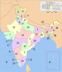
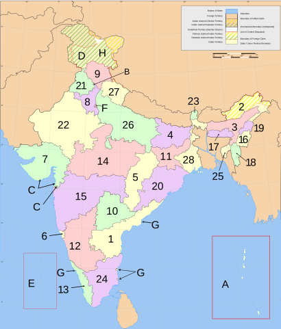
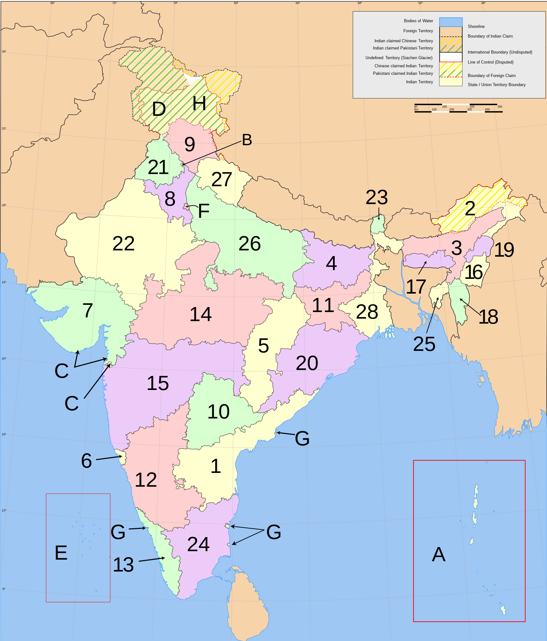
English: Main administrative divisions of india
India consists of 28 states and eight union territories. All states, and the three union territories of Jammu and Kashmir, Puducherry and Delhi, have elected legislatures and governments patterned on the Westminster model. The other five union territories are directly ruled by the Central government through appointed administrators. In 1956, under the States Reorganisation Act, states were formed on a linguistic basis.[1] Since then, this structure has remained largely unchanged.
Each state or union territory is further divided into administrative districts.[2] The districts in turn are further divided into:
- in rural areas: (named tehsils / taluks / mandals / subdivisions / circles / communes depending of the state or territory), local councils (gram panchayats), and eventually into villages and wards (gram sabhas), or
- in large urban areas: metropoles (comparable to subdistricts but with more autonomy), municipalities (or municipal corporations), and eventually into civic zones and civic wards.
For interstate cooperation and planning, the 28 states and 8 union territories are also grouped into 6 zones.
- States
- Andhra Pradesh
- Arunachal Pradesh
- Assam
- Bihar
- Chhattisgarh
- Goa
- Gujarat
- Haryana
- Himachal Pradesh
- Telangana
- Jharkhand
- Karnataka
- Kerala
- Madhya Pradesh
- Maharashtra
- Manipur
- Meghalaya
- Mizoram
- Nagaland
- Orissa
- Punjab
- Rajasthan
- Sikkim
- Tamil Nadu
- Tripura
- Uttar Pradesh
- Uttarakhand
- West Bengal
- Union territories
Esperanto: Subŝtatoj kaj teritorioj de Barato
- Subŝtatoj
- Andra-Pradeŝo
- Arunaĉal-Pradeŝo
- Asamo
- Biharo
- Ĉatisgaro
- Goao
- Guĝarato
- Harjano
- Himaĉal-Pradeŝo
- Ĝamuo kaj Kaŝmiro
- Ĝarkhando
- Karnatako
- Keralao
- Madhja-Pradeŝo
- Maharaŝtro
- Manipuro
- Meghalajo
- Mizoramo
- Nagalando
- Oriso
- Panĝabo
- Raĝastano
- Sikimo
- Tamilnado
- Tripuro
- Utar-Pradeŝo
- Utarakando
- Okcidenta Bengalio
- Telangano
- Uniaj teritorioj
Norsk nynorsk: Indiske statar og territorium
- Statas
- Andhra Pradesh
- Arunachal Pradesh
- Assam
- Bihar
- Chhattisgarh
- Goa
- Gujarat
- Haryana
- Himachal Pradesh
- Jammu og Kashmir
- Jharkhand
- Karnataka
- Kerala
- Madhya Pradesh
- Maharashtra
- Manipur
- Meghalaya
- Mizoram
- Nagaland
- Orissa
- Punjab|
- Rajasthan
- Sikkim
- Tamil Nadu
- Tripura
- Uttar Pradesh
- Uttarakhand
- Vest-Bengal
- Telangana
- Unionsterritorium
References
- ↑ States Reorganisation Act, 1956. Constitution of India. Commonwealth Legal Information Institute. Archived from the original on 2008-05-16. Retrieved on 31 October 2007.; See also: Political integration of India.
- ↑ Districts of India. Government of India. National Informatics Centre (NIC). Retrieved on 25 November 2007.
许可协议

|
已授权您依据自由软件基金会发行的无固定段落及封面封底文字(Invariant Sections, Front-Cover Texts, and Back-Cover Texts)的GNU自由文件许可协议1.2版或任意后续版本的条款,复制、传播和/或修改本文件。该协议的副本请见“GNU Free Documentation License”。 |
| 本文件采用知识共享署名-相同方式共享 3.0 未本地化版本许可协议授权。 | ||
| ||
| 本许可协议标签作为GFDL许可协议更新的组成部分被添加至本文件。 |
文件历史
点击某个日期/时间查看对应时刻的文件。
| 日期/时间 | 缩略图 | 大小 | 用户 | 备注 | |
|---|---|---|---|---|---|
| 当前 | 2021年1月10日 (日) 18:08 | | 1,594 × 1,868(306 KB) | Sbb1413(留言 | 贡献) | Updated further. |
| 2016年1月25日 (一) 12:24 |  | 1,594 × 1,868(309 KB) | Csyogi(留言 | 贡献) | Telangana State update | |
| 2011年12月3日 (六) 04:35 |  | 1,594 × 1,868(297 KB) | Kmusser(留言 | 贡献) | Re-size Goa label | |
| 2011年11月24日 (四) 18:38 |  | 1,594 × 1,868(276 KB) | Fred the Oyster(留言 | 贡献) | Tidy up, use Arial font as more 'universal' | |
| 2011年10月5日 (三) 15:34 |  | 1,594 × 1,868(298 KB) | Citypeek(留言 | 贡献) | changed font from Sans to DejaVu Sans. | |
| 2007年3月5日 (一) 07:51 |  | 1,594 × 1,868(304 KB) | Nichalp(留言 | 贡献) | Swapping Pondicherry NCT | |
| 2007年3月4日 (日) 05:59 |  | 1,594 × 1,868(304 KB) | Nichalp(留言 | 贡献) | Correction in the numbering scheme according to MoS | |
| 2007年2月15日 (四) 15:58 |  | 1,594 × 1,868(304 KB) | Nichalp(留言 | 贡献) | Reverted to earlier revision | |
| 2007年2月12日 (一) 00:39 |  | 1,594 × 1,868(304 KB) | Abecedare(留言 | 贡献) | Reverted to earlier revision | |
| 2006年11月25日 (六) 06:07 |  | 1,594 × 1,868(304 KB) | Nichalp(留言 | 贡献) | Reverted to earlier revision |
您不可以覆盖此文件。
文件用途
以下5个页面使用本文件:
全域文件用途
以下其他wiki使用此文件:
- ang.wikipedia.org上的用途
- an.wikipedia.org上的用途
- ast.wikipedia.org上的用途
- as.wikipedia.org上的用途
- ban.wikipedia.org上的用途
- be-tarask.wikipedia.org上的用途
- be.wikipedia.org上的用途
- bg.wikipedia.org上的用途
- bh.wikipedia.org上的用途
- blk.wikipedia.org上的用途
- bn.wikipedia.org上的用途
- bpy.wikipedia.org上的用途
- br.wikipedia.org上的用途
- bs.wikipedia.org上的用途
- ca.wikipedia.org上的用途
- da.wikipedia.org上的用途
- diq.wikipedia.org上的用途
- dv.wikipedia.org上的用途
- el.wikipedia.org上的用途
- en.wikipedia.org上的用途
- File talk:India-locator-map-blank.svg
- User:Jonny-mt/Gallery of current first-level administrative country subdivisions maps
- Template talk:Christianity in India sidebar
- Talk:Serbia/Archive 4
- File:India-states.svg
- File:Indiastates.jpg
- Talk:India/Archive 28
- Wikipedia:Graphics Lab/Map workshop/Archive/Dec 2011
- Talk:China/Archive 15
- User:Gufranazmi
- User:Ibsind
- Wikipedia:Graphics Lab/Map workshop/Archive/Mar 2018
- en.wiktionary.org上的用途
- es.wikipedia.org上的用途
查看本文件的更多全域用途。