File:Sassanid Empire 620.png
跳转到导航
跳转到搜索
没有更高的分辨率。
Sassanid_Empire_620.png (250 × 165像素,文件大小:3 KB,MIME类型:image/png)
说明
说明
添加一行文字以描述该文件所表现的内容
摘要
[编辑]
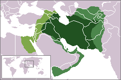
| 描述 | Sassanid Empire at its greatest extent. ca. 620 CE: lighter: vassal territories; more yellow: 620 conquest against Byz. Empire |
| 日期 | |
| 来源 | own work - based on WP locator maps Category:Locator_maps; boundaries as per en:Image:Sassanid Empire.jpg |
| 作者 | self, based on WP locator maps Category:Locator_maps |
| 授权 (二次使用本文件) |
GFDL (derived from PD work) |

|
File:Sassanid Empire 620-627.svg是此文件的矢量版本。 如果此文件质量不低于原点阵图,就应该将这个PNG格式文件替换为此文件。
File:Sassanid Empire 620.png → File:Sassanid Empire 620-627.svg
更多信息请参阅Help:SVG/zh。 |
 |
许可协议
[编辑]
我,本作品著作权人,特此采用以下许可协议发表本作品:

|
已授权您依据自由软件基金会发行的无固定段落及封面封底文字(Invariant Sections, Front-Cover Texts, and Back-Cover Texts)的GNU自由文件许可协议1.2版或任意后续版本的条款,复制、传播和/或修改本文件。该协议的副本请见“GNU Free Documentation License”。 |
| 本文件采用知识共享署名-相同方式共享 3.0 未本地化版本许可协议授权。 | ||
| ||
| 本许可协议标签作为GFDL许可协议更新的组成部分被添加至本文件。 |
- 您可以自由地:
- 共享 – 复制、发行并传播本作品
- 修改 – 改编作品
- 惟须遵守下列条件:
- 署名 – 您必须对作品进行署名,提供授权条款的链接,并说明是否对原始内容进行了更改。您可以用任何合理的方式来署名,但不得以任何方式表明许可人认可您或您的使用。
- 相同方式共享 – 如果您再混合、转换或者基于本作品进行创作,您必须以与原先许可协议相同或相兼容的许可协议分发您贡献的作品。
您可以选择您需要的许可协议。
文件历史
点击某个日期/时间查看对应时刻的文件。
| 日期/时间 | 缩略图 | 大小 | 用户 | 备注 | |
|---|---|---|---|---|---|
| 当前 | 2022年11月27日 (日) 13:25 | | 250 × 165(3 KB) | Gyalu22(留言 | 贡献) | removed date |
| 2018年5月8日 (二) 16:40 |  | 250 × 165(8 KB) | Trecătorul răcit(留言 | 贡献) | Empire itself, vassal territories and conquests of 620 distinguished | |
| 2011年1月14日 (五) 11:53 |  | 250 × 165(6 KB) | Cplakidas(留言 | 贡献) | more realistic borders & corrections, per http://ecai.org/sasanianweb/sasanianmapmenu.html | |
| 2007年2月15日 (四) 14:59 |  | 250 × 165(5 KB) | Aivazovsky~commonswiki(留言 | 贡献) | ||
| 2007年2月15日 (四) 14:52 |  | 250 × 165(5 KB) | Aivazovsky~commonswiki(留言 | 贡献) | Fixing Caucasus borders | |
| 2006年8月9日 (三) 14:27 |  | 250 × 165(6 KB) | Cp(留言 | 贡献) | {{Information |Description=Sassanid Empire at its greatest extent. ca. 610 CE. |Source=own work - based on WP locator maps Category:Locator_maps; boundaries as per en:Image:Sassanid Empire.jpg |Author=self, based on WP locator maps [[:Category:Lo |
您不可以覆盖此文件。
文件用途
以下29个页面使用本文件:
- Atlas of Abkhazia
- Atlas of Afghanistan
- Atlas of Armenia
- Atlas of Azerbaijan
- Atlas of Bahrain
- Atlas of Egypt
- Atlas of Georgia
- Atlas of Iran
- Atlas of Iraq
- Atlas of Iraqi Kurdistan
- Atlas of Kurdistan
- Atlas of Kuwait
- Atlas of Kyrgyzstan
- Atlas of North Ossetia – Alania
- Atlas of Oman
- Atlas of Qatar
- Atlas of Saudi Arabia
- Atlas of South Ossetia
- Atlas of Syria
- Atlas of Tajikistan
- Atlas of Turkey
- Atlas of Turkmenistan
- Atlas of Uzbekistan
- Atlas of Western Kurdistan
- Atlas of the Levant
- Atlas of the United Arab Emirates
- ایران
- User:Minorax/SVG available/2022 November 25-30
- File:Sassanid-empire-610CE.png(文件重定向)
全域文件用途
以下其他wiki使用此文件:
- ar.wikipedia.org上的用途
- az.wikipedia.org上的用途
- ba.wikipedia.org上的用途
- be-tarask.wikipedia.org上的用途
- be.wikipedia.org上的用途
- ca.wikipedia.org上的用途
- cs.wikipedia.org上的用途
- de.wikipedia.org上的用途
- en.wikipedia.org上的用途
- es.wikipedia.org上的用途
- fa.wikipedia.org上的用途
- fi.wikibooks.org上的用途
- fr.wikipedia.org上的用途
- hi.wikipedia.org上的用途
- hu.wikipedia.org上的用途
- hy.wikipedia.org上的用途
- id.wikipedia.org上的用途
- it.wikipedia.org上的用途
查看此文件的更多全域用途。