User talk:NordNordWest/Archive13
Favour[edit]
Hey, do you think it's possible that you can separately upload maps of separate coloured districts on Azerbaijan adm location map? I have no idea how to properly colour the single districts as an SVG file and the only available colour district maps are outdated, showing old occupation borders. It's alright if you don't. Thanks in advance. CuriousGolden (talk) 19:35, 10 December 2020 (UTC)
- I think we wait a while if there will be some further changes to the location map. Otherwise we will have to correct lots of derivative maps again and again. NNW 18:47, 11 December 2020 (UTC)
- You are right. That'd be best. CuriousGolden (talk) 19:13, 11 December 2020 (UTC)
Hello again! Do you think enough time has passed by now? Cheers. CuriousGolden (talk) 10:51, 5 February 2021 (UTC)
- I didn't have a look for what happens in Azerbaijan for a while so I cannot say if there is new information. Do you know more? NNW 16:54, 5 February 2021 (UTC)
- There's no new development since our last conversation. If you mean any news on the conflict area, there's this detailed map of the situation there and it has stayed like that for the last 2-3 months. About the district maps, there is an outdated version of the coloured districts maps like this and this, yet they have outdated occupation borders and the overall map is not as detailed and good-looking as Azerbaijan adm location map. CuriousGolden (talk) 18:52, 5 February 2021 (UTC)
- I didn't want to pester you, so I tried to give a hand and try doing it myself, however, I've no idea what program you've used for the SVG as it got messed up in both Illustrator and Inkscape. Could you tell me what program you've used and if not, fill the districts yourself? Cheers. CuriousGolden (talk) 06:51, 3 March 2021 (UTC)
- I usually use Illustrator but sometimes Inkscape. Perhaps I can start next weekend with these maps. NNW 18:24, 4 March 2021 (UTC)
- I tried to open it in both of them but the file was somewhat corrupted and the layers were messed up (perhaps I suck at editing SVGs?). It'd be great if you tried it. All we need is a red fill of each district. Cheers. CuriousGolden (talk) 19:00, 4 March 2021 (UTC)
- I usually use Illustrator but sometimes Inkscape. Perhaps I can start next weekend with these maps. NNW 18:24, 4 March 2021 (UTC)
- I didn't want to pester you, so I tried to give a hand and try doing it myself, however, I've no idea what program you've used for the SVG as it got messed up in both Illustrator and Inkscape. Could you tell me what program you've used and if not, fill the districts yourself? Cheers. CuriousGolden (talk) 06:51, 3 March 2021 (UTC)
- There's no new development since our last conversation. If you mean any news on the conflict area, there's this detailed map of the situation there and it has stayed like that for the last 2-3 months. About the district maps, there is an outdated version of the coloured districts maps like this and this, yet they have outdated occupation borders and the overall map is not as detailed and good-looking as Azerbaijan adm location map. CuriousGolden (talk) 18:52, 5 February 2021 (UTC)
- As I feared: I started the map series and now this. Wrong order and I can delete what I have done this afternoon. NNW 19:53, 6 March 2021 (UTC)
- I'm sorry, I only dived deep into the map now and I thought I still had time (I thought you meant next weekend, as in a week later). Really sorry. CuriousGolden (talk) 19:54, 6 March 2021 (UTC)
- All new maps can be found in Category:SVG locator maps of rayons in Azerbaijan (location map scheme). NNW 17:22, 7 March 2021 (UTC)
- Thank you very much! CuriousGolden (talk) 17:30, 7 March 2021 (UTC)
- You seemed to miss this one, could you also upload an updated version of Nakhchivan Autonomous Republic, please? Cheers. CuriousGolden (talk) 20:24, 7 March 2021 (UTC)
- Nakhchivan Autonomous Republic in Azerbaijan 2021.svg. NNW 20:25, 8 March 2021 (UTC)
- Thanks. Could you lower the opacity of Nagorno-Karabakh to around 40% in the districts that fall on it (e.g. Kalbajar, Tartar, Khojaly, Khojavend, Agdam, Khojavend, Lachin)? The current differences in colour is too noticeable and it almost looks like they're 2 completely different parts, when they're same district. I tried doing it, but the size of the image keeps getting messed up (is this normal? and is it fine if it's lower size?). It'd be fine to just change it in the district maps I mentioned before rather than all districts. CuriousGolden (talk) 14:00, 9 March 2021 (UTC)
- Most readers see these maps with 220px width in an infobox. The areas of the districts are quite small then so you need a bigger difference between the colours than in a bigger appearance. At least it is not as different as in Azerbaijan-Kalbajar.png. :o) NNW 17:47, 10 March 2021 (UTC)
- Thanks. Could you lower the opacity of Nagorno-Karabakh to around 40% in the districts that fall on it (e.g. Kalbajar, Tartar, Khojaly, Khojavend, Agdam, Khojavend, Lachin)? The current differences in colour is too noticeable and it almost looks like they're 2 completely different parts, when they're same district. I tried doing it, but the size of the image keeps getting messed up (is this normal? and is it fine if it's lower size?). It'd be fine to just change it in the district maps I mentioned before rather than all districts. CuriousGolden (talk) 14:00, 9 March 2021 (UTC)
- Nakhchivan Autonomous Republic in Azerbaijan 2021.svg. NNW 20:25, 8 March 2021 (UTC)
- You seemed to miss this one, could you also upload an updated version of Nakhchivan Autonomous Republic, please? Cheers. CuriousGolden (talk) 20:24, 7 March 2021 (UTC)
- Thank you very much! CuriousGolden (talk) 17:30, 7 March 2021 (UTC)
- All new maps can be found in Category:SVG locator maps of rayons in Azerbaijan (location map scheme). NNW 17:22, 7 March 2021 (UTC)
- I'm sorry, I only dived deep into the map now and I thought I still had time (I thought you meant next weekend, as in a week later). Really sorry. CuriousGolden (talk) 19:54, 6 March 2021 (UTC)
- As I feared: I started the map series and now this. Wrong order and I can delete what I have done this afternoon. NNW 19:53, 6 March 2021 (UTC)
Questions about Location and Locator Maps conventions[edit]
Hello NordNordWest! I have some questions about location and locator maps' conventions which I feel you are one of the best to answer, given your extensive work regarding them. I asked this question on the WikiProjectMaps talk page, too, but it is quite inactive so I thought I'd get a quicker answer by contacting a creator directly.
- Do locator maps require rivers and lakes to be shown, and if so, which lakes and rivers qualify as being significant enough to be shown on the map, and where can we find a database of these rivers and lakes?
- Are there specified line thicknesses and colors used for borders between nations and/or subnational units, and if there are, what are they? Currently, I'm making a raster locator map (I can convert it to SVG format later if necessary) where first-level subnational units are 10px thickness on a large image file and using #555555 color, the second-level units are 5px using #6f6f6f, and third-level units are #888888 and 3px. What do you think about this?
- Is the .SVG file format really mandatory for locator and location maps? I've been through many articles on Wikipedia and have seen numerous instances of a .PNG file being used instead of .SVG file for locator maps (examples Dallas, Stockholm, Santiago, and many many more if you'd look).
-- Abbasi786786 (talk) 19:00, 3 January 2021 (UTC)
- Hello!
- 1) Rivers and lakes help to find a location in a country because they are better known by the reader than boundaries. You should make a good selection: the longest, biggest rivers. The same with lakes. Reservoirs should be connected to the main river that flows through it (I think). How many rivers? Well, that depends on the scale. In areas where OSM is okay you might use it, perhaps you need to scan a map from an atlas to fill holes. Just try what you are able to do.
- 2) The thickness of lines isn't specified. In the end every location map has to work in an infobox, so sometimes the lines are thicker, sometimes they are thinner. You better upload your file and check in at the file description page. If needed you change the thickness of lines. Until now all boundaries have got the same colour and only differ in thickness. More colours often make it more difficult to understand a map.
- 3) SVG is the better file format. Any update of a PNG is a bunch of work or even impossible, especially with relief location maps. The hugh majority of location maps is indeed a screenshot but that is not really my field of work. NNW 18:04, 4 January 2021 (UTC)
 |
⭐ A file you uploaded is on the main page! ⭐
File:Aral Sea.gif, that you uploaded, is on the main page today. Thank you for your contributions to this project. |
//EatchaBot (talk) 00:00, 5 January 2021 (UTC)
Maps of the Finnish regions[edit]
Hello. Some of the region specific maps for the regions of Finland need to be updated but I personally lack the knowledge on GIS systems and such. Main issue with them is the bounding boxes as the current ones are too small to display the new borders for the region. The original creator for these maps seems to be inactive and since you seem to be pretty handy with various map related issues and was wondering if you could help. The files needing update are
- File:Finland North Karelia Region.svg
- File:Finland Northern Savonia Region.svg
- File:Finland Pirkanmaa Region.svg
- File:Finland Päijät-Häme Region.svg
Thank you in advance. --Fenn-O-maniC (talk) 17:02, 29 January 2021 (UTC)
- That's really some work to do. The files need to make bigger and the bordering coordinates have to be defined anew. That is nothing I can do in short time. First of all I have to check the Finnish website where the data is from. NNW 18:14, 29 January 2021 (UTC)
Where you get data from for maps of South Asia[edit]
Just wondering where you got data from for maps of India, Pakistan and Bangladesh. Your national maps seem to line up correctly with the coastlines in these regions in a way not done by any current location map for subnational divisions there, so I'm assuming they are accurate boundaries. Where does the data come from? US national imagery data is very vague, I looked and it seems you have to have some special login in order to access it. Is that how you get the data? C1MM (talk) 05:10, 30 January 2021 (UTC)
- Data usually used for my country maps is en:Vector Map Level Zero. But this data is outdated or even incorrect so I often grab a satellite image and update/correct it. I think that's the main difference to other map contributors: most of them don't check their free data. NNW 13:51, 30 January 2021 (UTC)
- Ah, that makes sense. What about information about administrative boundaries such as provinces, states etc? C1MM (talk) 18:29, 31 January 2021 (UTC)
- @NordNordWest: I simplified layering for India location map (no nested layers inside groups like there is now) and merged all international provinces/subdivisions in the other countries layer into a single path and reduced the document size to ~1.3 MB. Is it best if I upload this now under a different name and then some administrator can grab it and update the actual file and delete the placeholder? C1MM (talk) 04:26, 2 February 2021 (UTC)
- I think you describe this to some administrator to unprotect the file and you can upload your version. NNW 16:51, 5 February 2021 (UTC)
- @NordNordWest: OK, will do, also can you possibly update the map of Tamil Nadu? The district borders are not accurate nor is the river data. If you can find Tamil Nadu data with updated districts and accurate river boundaries that would be great. C1MM (talk) 16:26, 20 February 2021 (UTC)
- Not right now. I am really lacking time. NNW 09:41, 22 February 2021 (UTC)
- @NordNordWest: OK, will do, also can you possibly update the map of Tamil Nadu? The district borders are not accurate nor is the river data. If you can find Tamil Nadu data with updated districts and accurate river boundaries that would be great. C1MM (talk) 16:26, 20 February 2021 (UTC)
- I think you describe this to some administrator to unprotect the file and you can upload your version. NNW 16:51, 5 February 2021 (UTC)
- @NordNordWest: I've been doing a lot of work with relief maps over the past months and haven't found a good way to produce good hillshade for large regions. Unless the map scale is small enough the hillshade itself doesn't show. How do you ensure the hillshade is big enough to show? For instance in your map of Tibet, hillshade is very visible. Similarly in relief maps of Madhya Pradesh and Jharkhand hillshade is very visible. What settings do you use to get that to work? I've tried changing the scaling and z factor (I'm using QGIS with STRM30). C1MM (talk) 16:27, 19 March 2021 (UTC)
- I use some old but great software that is able to intensify a relief if needed but it isn't available no longer (and you need to have an old MacOS). NNW 17:59, 20 March 2021 (UTC)
I want to make some changes to your location map of West Bengal by modifying coastline and rivers, but the file is almost 3 times as big (840 kB compared to 360 in the original). I won't upload it until I figure out how to reduce the file size to a comparable level to current size (maybe 500 kB as max). Know any good ways of ensuring I get a good level of detail in rivers/coastline while also keeping file size low? C1MM (talk) 05:00, 31 March 2021 (UTC)
- It is just a question of how many elements and how many single points your file has got. Some applications are able to reduce the amount of points while keeping the lines nearly in the same shape as before. Perhaps you work with an application which is able to do that, too. Btw I prefer announcing the will to change a file before this happens. There might exist derivative files which would have to be changed, too, and I have learned that almost nobody of the file changers thought of that problem before and asked the original uploader although that would have been the easiest way. NNW 10:11, 31 March 2021 (UTC)
- Got it. I mentioned earlier that I won't overwrite your file unless I get your OK or I get your help on correcting the issue at hand, i.e. your file doesn't show islands of the delta in enough detail. The main problems with reducing file size is the ocean (right now around 1800 nodes in size, even though the coastline and islands combined only work out to ~1100 nodes) and rivers (specifically the Teesta/Brahmaputra/Ganga/Kosi which I am using a wide-river type format for, this alone is ~2500 nodes, although riverbanks combined are only ~1300 nodes). Current file size is 726 kB. Is this file size acceptable for a location map or should I try to reduce it? If that file size is OK I'll upload, otherwise how can I reduce number of nodes further? C1MM (talk) 05:05, 2 April 2021 (UTC)
- The main question is not the size file (there are location maps that are much more bigger), it is a question of scale (~ 1:1.250.000), the way it is used (220px width is standard) and the adequat cartographic generalization for that. I cannot show all rivers, it is senseless to try to show all islands. It is impossible to decide if any change is sensible or not unless I haven't seen it. I remember someone who wanted to show even the smallest border curves at a country with a North to South extension of more than 4000 km. That is rubbish, this is not OSM or Google Maps where I can zoom. It is important to have this in mind. NNW 17:39, 3 April 2021 (UTC)
- Yes, but there are some islands that are clearly distinguishable at that scale that aren't included as islands, especially the Western Sunderbans. And some rivers are flowing in the wrong places, the Kosi for instance (maybe it's because it's shifted over time, I used Landsat images from this year). That's mainly what I was trying to correct. Also, I have a version of your location map with rivers of Bhutan, is it OK if I overwrite your file with that version? Only change I am making is adding rivers. C1MM (talk) 15:00, 4 April 2021 (UTC)
- Then do it. NNW 15:49, 4 April 2021 (UTC)
- OK if I do the same above to location maps of Kerala and Bihar? Both have similar issues - rivers were in the wrong places and some villages were in the wrong districts. C1MM (talk) 05:41, 22 August 2021 (UTC)
- If you want to... NNW 09:07, 22 August 2021 (UTC)
Kiribati map[edit]
Hi NordNordWest, I understand why you reverted my version of the Kiribati location map, but the old one seems to have inaccuracies around the edges. As I'm sure you can tell, it's not easy to see any of the islands on the map at present, or the international boundaries, or indeed to distinguish between the two. Is there a way of seeing the location map style guidelines? Maybe a modification of the style for remotes island nations can be discussed. Regards, Amitchell125 (talk) 14:07, 24 February 2021 (UTC)
- Hello! The style guidelines for this map can be found at Positionskartenerstellung - Signaturvorlage.png. The boundaries on maps for countries like Kiribati are (of course) not like land boundaries. They only try to show which islands belong to one country. The "real" boundaries would be 12 nautical miles around each island. If there are some missing islands they can be added but I would prefer when you tell me which ones because there are several derivative maps which would have to be updated, too. NNW 15:28, 24 February 2021 (UTC)
B9 Namibia[edit]
Hallo NNW. Wenn Du Zeit und List hast, würde ich mich über eine Karte analog zu File:Map NAM B1.svg zur de:Nationalstraße B9 in Namibia freuen. Verlauf habe ich Dir hier eingezeichnet [1] Danke. --Chtrede (talk) 15:54, 2 March 2021 (UTC)
- Hallo! Dann muss ja auch die Karte zur A1 verändert werden, die dann offensichtlich verkürzt wurde. Und dito die B1, weil die A1, lt. Artikel, weiter im Norden anfängt. NNW 17:33, 2 March 2021 (UTC)
Karte U-Bahn Hamburg Netzplanung 1955[edit]
Moin! Bei dieser Karte hat sich in der Legende ein Tippfehler eingeschlichen. Es müsste heißen: der Planung nach aufzugebende Strecken (nicht: aufzugegebene) Gruß --Alexander Kropholler (talk) 05:20, 22 March 2021 (UTC)
- Moin und danke für den Hinweis! Das werde ich korrigieren. Viele Grüße, NNW 06:58, 22 March 2021 (UTC)
Hoi NordNordWest, habe mir erlaubt, die Grenze im Untersee einzuzeichnen. Dort gibt es im Gegensatz zum restlichen Bodensee eine definierte Grenze. Gruss Peter
- Moin! Ich weiß. Ich hatte aus grafischen Gründen darauf verzichtet, damit der Untersee besser zu sehen ist. Aber meinetwegen. Viele Grüße, NNW 19:33, 22 March 2021 (UTC)
S-Bahn Mitteldeutschland - Liniennetz.svg[edit]
Hallo NNW!
Seit deiner Korrektur wird die Beschriftung zumindest bei mir etwas in sich verschoben angezeigt.--Köhl1 (talk) 11:05, 24 March 2021 (UTC)
- Moin! Wenn ich mich recht erinnere, ist die Schrift in der Datei umgewandelt, sprich es gibt keinen echten Text mehr. Kannst du mir ein Beispiel nennen, wo es dir auffällt? NNW 11:23, 24 March 2021 (UTC)
- Es geht um die Überschrift links oben. Die überlagert sich sowohl hier in Commons als auch im Artikel in de. Ich habe das mit firefox und chrome ausprobiert. --Köhl1 (talk) 12:30, 29 April 2021 (UTC)
- Ich habe die Überschrift neu getippt, die war irgendwie zerdengelt.
Straßenkartenwunsch[edit]
Lieber NNW,
nachdem ich wieder an Bord bin, will ich den Artikel de:Lerchenfeld (Hamburg) schreiben und hätte den Wunsch, dass Du in bewährter Manier eine entsprechende Karte dafür erstellst.
Vielen Dank vom Mogelzahn (talk) 14:39, 2 April 2021 (UTC)
- Moin! Ich habe im Moment wenig Zeit (und leider auch wenig Lust) auf Wikipedia. Das kann also dauern. Viele Grüße, NNW 17:40, 3 April 2021 (UTC)
- Das ist dann so, ist ja immer noch ein Freiwilligenprojekt. --Mogelzahn (talk) 18:23, 3 April 2021 (UTC)
Falls Du dereinst mal wieder Zeit und Lust hast, würde ich mich auch über eine Karte zur Wartenau freuen. Falls das aber nicht absehbar ist, wäre ich auch über einen Hinweis auf einen entsprechenden Kollegen, den ich ansprechen kann, dankbar. Ich hoffe, Dir geht es gut und bedanke mich schonmal. --Mogelzahn (talk) 13:29, 3 May 2021 (UTC)
- Da hast du Glück, ich hatte schon die Grundlage: Karte Wartenau.png. Ansonsten glaube ich nicht, dass sonst wer diese Karte machen würde, die Kartenwerkstatt ist fast tot. NNW 17:23, 3 May 2021 (UTC)
- Vielen Dank! Schae, dass die Kartenwerkstatt, deren Mitglieder ja immer tolle Arbeit gemacht haben, fast tot ist. --Mogelzahn (talk) 19:16, 3 May 2021 (UTC)
svp ajout du Phnom Dei[edit]
Bonjour NordNordWest,
Je suis parrainée par Jacques Ballieu et je souhaiterais ajouter la page Temple Phnom Dei aux temples d'Angkor avec sa localisation, (c'est aussi une des communes) dans le district de Phnom Srok au sud-Est de Banteay Srei et à 20 Km de Phnom Kulen, donc en fait dans la province de Siem Reap. Cela permettrait d'avoir la localisation de Phnom Dei sur la carte et Phnom Dei dans la liste des temples. J'ai hésité à mettre en avant la colline (comme le wiki Anglais) par rapport au Temple. mais compte tenu du rôle de l'EFEO, j'ai pensé qu'il valait mieux mettre en avant le temple. (à discuter)
En vous remerciant pour aide, A très bientôt, --Atalante88 (talk) 07:38, 24 April 2021 (UTC)
- Hello! Can you give me a link so I can see which article or file you are talking about? Regards, NNW 08:26, 24 April 2021 (UTC)
File:Spreading homo sapiens la.svg[edit]
Eine hübsche Grafik, nur woher kommen die Informationen und Zahlen? Dass Madagaskar und Neuseeland 1500 Jahre vor der Gegenwart erreicht wurden, ist doch bestimmt nicht richtig. Ist das aber falsch, so sind die anderen Zahlen doch auch nicht glaubwürdig, oder ? --Pp.paul.4 (talk) 22:27, 28 April 2021 (UTC)
- Moin! Das ist eine Übersetzung der russischen Datei. Lt. de:Neuseeland#Entdeckung und Besiedlung durch Polynesier erfolgte die Besiedelung Neuseelands "Ende des 13. Jahrhunderts, spätestens aber in der ersten Hälfte des 14. Jahrhunderts". Madagaskar scheint zumindest lt. de:wp tatsächlich falsch zu sein, aber nicht so stark, wie man denken könnte. NNW 06:08, 29 April 2021 (UTC)
- Laut de:Mensch#Entwicklungsgeschichte und Ausbreitung der Spezies (linkt nicht richtig) stehen die Zahlen für „Jahre vor heute“, daher sollte man bei Neuseeland die Zahl 700 erwarten. Jedenfalls sollte in die Legende, was die Zahlen bedeuten und woher sie stammen. --Pp.paul.4 (talk) 16:57, 29 April 2021 (UTC)
- Das kannst du gerne machen. Ich habe nur einen Übersetzungswunsch erfüllt und die Karte nicht grunderstellt, kann daher auch nichts zu den Quellen sagen. NNW 17:05, 29 April 2021 (UTC)
Nepal maps[edit]
Can you update File:Nepal Sudurpashchim Pradesh adm location map.svg and File:Nepal Sudurpashchim Pradesh rel location map.svg these maps to match this File:Nepal adm location map.svg. Thanks. Bada Kaji (talk) 10:39, 12 May 2021 (UTC)
- I am too busy right now, especially as I would have to change the size of the maps. It will take some time but I didn't have forgotten to do this. NNW 10:27, 15 May 2021 (UTC)
SVG rel location map[edit]
-
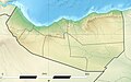 Somaliland relief location map

- Hi @NordNordWest: , I saw your great work making Location maps and i would to like request you.
- Could please make svg map of relief location.
- Many Thanks- --Siirski (talk) 17:36, 24 May 2021 (UTC)
- Not in the next time, too busy for new location maps. Best regards, NNW 13:18, 25 May 2021 (UTC)

|
File:Alver komm.jpg has been listed at Commons:Deletion requests so that the community can discuss whether it should be kept or not. We would appreciate it if you could go to voice your opinion about this at its entry.
If you created this file, please note that the fact that it has been proposed for deletion does not necessarily mean that we do not value your kind contribution. It simply means that one person believes that there is some specific problem with it, such as a copyright issue. Please see Commons:But it's my own work! for a guide on how to address these issues. |
Worldlydev (talk) 08:39, 3 June 2021 (UTC)
NSG Dönche[edit]
Hallo, gerade gesehen: https://commons.wikimedia.org/wiki/File:Lage_KS-D%C3%B6nche.svg ist nicht das Naturschutzgebiet "Dönche",
Dies siehst Du hier: https://www.openstreetmap.org/way/31164444
vielleicht das gleichnamige (aber etwas größere) FFH-Gebiet? Gruß Baummapper (talk) 15:44, 6 June 2021 (UTC)
- Moin! Das bezieht sich auf de:Kassel#Stadtgliederung: Nicht als Ortsbezirk, sondern als ortsbezirksfreies Gebiet, zählt die Dönche, die sich als unbebautes Naturschutzgebiet im Südwesten von Kassel befindet. (https://www.openstreetmap.org/relation/9313125#map=15/51.2921/9.4331) NNW 16:09, 6 June 2021 (UTC)
- Ja, das war neben FFH mein zweiter Verdacht. Es halt so, dass das NSG "Dönche" damit nicht flächenidentisch ist. In OSM ist jetzt in Version #3 der NSG-Wikidata-Tag rausgeflogen und ein note reingekommen:
- https://www.openstreetmap.org/relation/9313125/history
- ... Baummapper (talk) 18:06, 6 June 2021 (UTC)
- Das steht jetzt seit 13 Jahre so in WP, ich wusste nichts vom Unterschied und kein Kasseler hat etwas dazu gesagt, genausowenig wie zum fehlenden Kragenhof, der immer noch in sehr vielen Kassel-Karten fehlt. NNW 06:21, 7 June 2021 (UTC)
- Mache dir wg. der Dönche keinen Vorwurf, da geht in den wikimedia-Projekten so einiges schief. Weil ich mich mit den (nord)hessischen NSG-Geodaten beschäftige fällt mir das dann auf. Von mir neu angelegte Commons-Kats zu NSGs haben auch immer ein "Naturschutzgebiet" als Präfix um Verwechslungen zu vermeiden. Habe mal hier reingeschaut:
- https://www.kassel.de/daten-und-karten/geoportal-kassel.php#Regionalstadtplan
- und im layer Politik+Verwaltung die Ortsbezirke eingeschaltet. Dort "Dönchelandschaft (ortsbezirksfrei)" - auf der Basis die Bildunterschrift im wikipedia-Artikel vergenauert:
- https://de.wikipedia.org/w/index.php?title=D%C3%B6nche&type=revision&diff=212751156&oldid=212704033
- sowie
- https://de.wikipedia.org/w/index.php?title=Kassel&type=revision&diff=212751884&oldid=212721349
- verständlich so?
- Was Kragenhof anbelangt, kannst Du im Geoportal sehen, dass der als externe Fläche zu "Wolfsanger-Hasenhecke" gehört ... Gruß Baummapper (talk) 08:52, 7 June 2021 (UTC)
Kannst du dir das mal anschauen[edit]
Hi! Kannst du dir mal User talk:Matti&Keti bzw dessen Uploads, insbesondere die Karten anschauen? (Ping dort hat wohl nicht funktioniert?) Dass der an der Erstellung der Karten am als Forscher beteiligt war stimmt wohl, und auch dass die im Auftrag entstanden, aber die eigentliche Arbeit hat wohl ein anderer gemacht. Und seine Antworten und das um-den-heißen-Brei-Gerede bzw nicht-Antworten auf Fragen lässt mein Vertrauen nicht wachsen. --Don-kun (talk) 21:07, 8 June 2021 (UTC) p.s. Kennst du diese originelle Nachnutzung von dir schon? --Don-kun (talk) 21:07, 8 June 2021 (UTC)
- Moin! Ich komme momentan zu praktisch gar nichts, ich muss mir das die Tage mal in Ruhe durchlesen. NNW 04:53, 11 June 2021 (UTC)
- Das geht jetzt eh schon so lange, da machen ein paar Tage oder Wochen mehr auch keinen Unterschied :) --Don-kun (talk) 13:14, 13 June 2021 (UTC)
Tour de France – Alpenanstiege[edit]
Bitte die Karte TdF Alpen aktualisieren. 2020 kam der Anstieg zum Col de la Loze hinzu (Kategorie HC; zwischen Courchevel und Val Thorens). Vielen Dank.--Superbia23 (talk) 10:50, 18 June 2021 (UTC)
- Ist ergänzt.
|
|
File:Sprachvarietäten Deutsch.png has been listed at Commons:Deletion requests so that the community can discuss whether it should be kept or not. We would appreciate it if you could go to voice your opinion about this at its entry.
If you created this file, please note that the fact that it has been proposed for deletion does not necessarily mean that we do not value your kind contribution. It simply means that one person believes that there is some specific problem with it, such as a copyright issue. Please see Commons:But it's my own work! for a guide on how to address these issues. |
E-960 (talk) 10:14, 23 June 2021 (UTC)
Data source for File:Azerbaijan adm location map (AZ POV).svg[edit]
Hi, I'm interested in your data source for File:Azerbaijan adm location map (AZ POV).svg, the source field doesn't have much information. I'm making a similar map for Iran and it would be very useful! Thanks — Berrely • T∕C 08:27, 24 July 2021 (UTC)
- Hello! I usually use my own databases as a cartographer and control them by looking at other (mainly official) sources. That's why you won't find the exact same boundary data of Azerbaijan elsewhere. You know that there already is a location map for Iran? NNW
Fehler in der Karte Germany Laender 1947 1990 DDR[edit]
Lieber NordNordWest, auf der genannten Karte habe ich einen Fehler gefunden - könntest Du hier helfen: File talk:Germany Laender 1947 1990 DDR.png#Berlin?--Gloser (talk) 13:08, 9 August 2021 (UTC)
File:Official languages in Africa.svg[edit]
Why you changes the map ? In Centrafrica, there are two oficials lenguages. --2A02:8440:4441:1F0A:34EC:8541:7D1:3ABA 13:05, 12 August 2021 (UTC)
Quality Image Promotion[edit]
 |
Your image has been reviewed and promoted
Congratulations! Mahnmal Opfer der NS-Verfolgung Ohlsdorf.jpg, which was produced by you, was reviewed and has now been promoted to Quality Image status. If you would like to nominate another image, please do so at Quality images candidates. We also invite you to take part in the categorization of recently promoted quality images.
|
--QICbot (talk) 05:20, 14 August 2021 (UTC)
Serbienkarte[edit]
Ahoi, bei der Betreuung von de:Vršac fiel mir die von dir angefertigte Karte Datei:Serbia adm location map.svg von 2015 auf. Inzwischen ist das Kosovo selbstständig. Wäre es nicht an der Zeit, die Karte umzuarbeiten? Ich kann es leider nicht. Kannst du es auf deine To-do-Liste nehmen? Grüße, --Aalfons (talk) 11:58, 20 August 2021 (UTC)
- Moin! Na ja: de:Internationale Anerkennung des Kosovo. Üblicherweise werden bei uns umstrittene Gebiete schraffiert dargestellt (eine Ausnahme: Positionskarte Kosovo, weil das sonst schlecht aussieht), daher sollte das hier auch so bleiben. Viele Grüße, NNW 16:36, 20 August 2021 (UTC)
New Zealand National League regional leagues map[edit]
-
 Map of New Zealand
 -
 English Football Conference county coverage


.svg)
.svg)
.svg)
.svg)
Hello NordNordWest, I see that you created the file of the map of New Zealand as shown above. I was wondering if you still had the file and were able to colour the regions in. What I would be looking for would be to have the Northland, Auckland, Waikato, and Bay of Plenty regions as one colour. The Gisborne, Hawke's Bay, Manawatū-Whanganui and Wellington regions as a second colour. And finally, the remaining regions; Tasman, Nelson, Marlborough, West Coast, Canterbury, Otago and Southland regions as a third colour. This would be used on the New Zealand National League page to differentiate the different regional leagues. Something like the English football leagues example above is what I'm looking for. Please let me know if you are able to help. Regards Kezyfooty (talk) 01:23, 22 August 2021 (UTC)
- Hello! No problem. What about Taranaki? NNW 09:16, 22 August 2021 (UTC)
- Thank you. Taranaki would be the second colour along with Gisborne, Hawke's Bay, Manawatū-Whanganui and Wellington. Thank you for pointing that out. Kezyfooty (talk) 13:31, 23 August 2021 (UTC)
- Awesome mate! Thank you so much. Kezyfooty (talk) 21:03, 23 August 2021 (UTC)
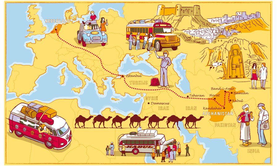
File:Hippie trail.svg[edit]
Hi, thanks for making this brilliant map. I actually added Beirut and Amman as the trail destinations on the map since they were missing labels.
I'm not good at SVG files so wanted to ask if you can make minor fixes. First of all altering the line in the Levant so that it goes to the dot of Beirut and then from there on to Amman.
Secondly, it seems the trail in Afghanistan is missing Kandahar. From other maps I've seen and photos of hippies at the time, it seems travelers would go from Herat in the west to Kandahar in the south, and then from there to Kabul in the east. However they also traveled to Bamyan in the center (which I can't be sure from where they got there).
It'd be good if you could shed some light at this issue. --Weaveravel (talk) 12:43, 31 August 2021 (UTC)
- Hello! I can do it in the next days. NNW 07:11, 1 September 2021 (UTC)
- Thanks! I do definitely think in Afghanistan there will have to be a change because of Bamyan. As you can see on this map for example, the route went from Herat down to Kandahar, then towards the central for Bamyan, and from there east to Kabul. --Weaveravel (talk) 20:35, 2 September 2021 (UTC)
- Hippie trail means only roughly a route. Not everyone visited exactly these places. NNW 06:16, 3 September 2021 (UTC)
- Thanks! I do definitely think in Afghanistan there will have to be a change because of Bamyan. As you can see on this map for example, the route went from Herat down to Kandahar, then towards the central for Bamyan, and from there east to Kabul. --Weaveravel (talk) 20:35, 2 September 2021 (UTC)
Umrißkarte Deutsches Reich 1937 in höherer Auflösung?[edit]
Moin NordNordWest,
wäre es möglich, die Karte German Empire 1937 adm location map.svg in drei- oder vierfacher Größe bereitzustellen? Wenn man eine größere Anzahl an Städten eintragen möchte wird es sonst recht schnell eng.
Außerdem möchte ich anregen, eine weitere Version zu erstellen die den Gebietsstand von Ende 1938 anzeigt. --2001:16B8:2B16:4C00:7DCA:FC32:4465:EF9F 08:24, 30 September 2021 (UTC)
- Moin! Eine Vektordatei kann ohne Qualitätsverlust in jede beliebige Größe skaliert werden, z. B. mit 10.000 Pixel Breite. NNW 16:15, 2 October 2021 (UTC)
Iran SVG map[edit]
Hello. Thanks for fixing Tabas in this map. Could you perhaps fix it in this file as well? 4nn1l2 (talk) 12:52, 30 September 2021 (UTC)
- Hello! It’s corrected now. NNW 16:43, 2 October 2021 (UTC)
File:Japan location map.svg and File:Japan location map with side map of the Ryukyu Islands.svg needs to be revamp for coastlines and its borders or boundaries.[edit]
Hello NordNordWest! I would those update boundaries and coastlines, because ome most of outside boundaries and coastlines that are became not beautiful, and it should to be correct using OpenStreetMap like File:Japan Kanto adm location map.svg should be matched as well. --2001:4450:46F1:BB00:19FD:8F27:9F6C:7271 10:00, 6 October 2021 (UTC)
- Both maps weren't made by me, you should discuss this with the uploader. Btw these maps show a hugh area and OSM uses Mercator, a projection which doesn't work as a location map when the distance between the Northern and Southern edge is too big. NNW 10:08, 6 October 2021 (UTC)
- In other maps, you should to upload and create your this map in this time, if this user is offline, no longer modify. --2001:4450:46F1:BB00:19FD:8F27:9F6C:7271 10:30, 6 October 2021 (UTC)
A barnstar for you![edit]

|
The Original Barnstar |
| Muy buen trabajo lo del mapa.
¿Tendrías como hacerme un mapa solo del departamento de Misiones en el cuál se ve la ciudad de Villa Florida? Así como se ve actualmente el puntito de ubicación en el mapa de Paraguay , pero solo con el mapa del departamento de Misiones quiero agregarlo a Wikipedia Villa Florida. También si es posible que subas la bandera y el escudo del Departamento de Misiones y si Villa Florida también tenga escudo y bandera. Fran secab (talk) 19:05, 8 October 2021 (UTC) |
Thank you! I’m quite busy in real life right now so I cannot promise to create such map. NNW 16:17, 10 October 2021 (UTC)
Update request[edit]
Hello.
Can you redraw the dashed de-facto border inside Azerbaijan in the relief map File:Reliefkarte Armenien.png, just like you did in the political map File:Armenia adm location map.svg? After the Second Karabakh War in 2020, the territory controlled by Armenians in Azerbaijan is much reduced. The current situation which will last until 2025, needs to be reflected in the relief map as well.
Yours sincerely, 31.200.20.246 15:39, 18 October 2021 (UTC)
- Hello! A ping to @Tschubby who created that file. NNW 15:41, 18 October 2021 (UTC)
- Thank you. 31.200.20.246 15:46, 18 October 2021 (UTC)
File:China adm location map.svg needs to be update borders[edit]
Hello NordNordWest. I would to be updated this map with provincial borders that compared as File:China Xinjiang adm location map.svg, File:China Gansu adm location map.svg, and File:China Qinghai location map.svg? --2001:4450:46C1:9A00:934:838:1697:52E8 22:59, 29 October 2021 (UTC)
- Hello! You are right, it's corrected now. NNW 18:12, 30 October 2021 (UTC)
- Thank you, but can you correct between Qinghai and Sichuan border as we not compared, also, Gansu borders to be changed for cities with Zhangye, Qingyang, and Wuwei, and as detail between Qinghai and Ningxia. Thanks. --2001:4450:46C1:9A00:7CC6:7031:C473:C8E1 04:03, 31 October 2021 (UTC)
- I corrected Qinghai/Sichuan and some minor things about Gansu. Qinghai and Ningxia aren't connected. NNW 18:20, 26 November 2021 (UTC)
File:China Chongqing location map.svg needs updating[edit]
Can you change and remove between former Wansheng and Shuangqiao Districts, and it was changed since October 2011. Aichi || Message me 13:05, 4 November 2021 (UTC)
- Thanks, it's updated now. NNW 18:44, 17 November 2021 (UTC)
Reason for Kashmir subregion maps being entire region[edit]
On the location maps for places like Jammu and Kashmir and Ladakh, etc., all the Kashmir subadministrative units, the location map shows the entire Kashmir region rather than just the region in question. Is there any particular reason for this, because I don't really see how it maintains neutrality better than simply showing the region in question without including the rest of them. C1MM (talk) 06:09, 17 November 2021 (UTC)
- Could you please link the files with that problem? India Jammu and Kashmir UT adm location map.svg (used in de:wp) only shows J&K. NNW 06:57, 17 November 2021 (UTC)
- File:India Jammu and Kashmir location map UN view.svg, File:India Ladakh location map UN view.svg, File:Azad Kashmir Location Map.svg, File:Gilgit Baltistan Location Map.svg. These are all used on English Wikipedia. C1MM (talk) 07:01, 17 November 2021 (UTC)
- Ah, okay, these weren't made by me. I think they show the old J&K area because someone wasn't able to crop it to the new size of the union territories. (And I have to correct India Ladakh adm location map.svg, there is no reason for showing the districts in J&K union territory). NNW 07:35, 17 November 2021 (UTC)
Fix request in File:Official languages in Africa.svg[edit]
Hello.
Can you fix Central Africa in File:Official languages in Africa.svg? It appears as white in the map. It should be colored in gray and blue, just like the previous version, because it has two official languages: Sango and French.
Thank you in advance.
31.200.21.214 17:22, 22 November 2021 (UTC)
- It's corrected now. Thank you! NNW 18:45, 22 November 2021 (UTC)
Ethiopian map[edit]
Could you update File:Map of zones of Ethiopia.svg? According to the UN, there are more zones now. I tried to do it myself but my system can barely handle the large vector files. And if possible could you also make a district map as well? Thanks. Ue3lman (talk) 02:43, 26 November 2021 (UTC)
- The original uploader should be asked first. @SUM1. NNW 18:07, 26 November 2021 (UTC)