User talk:NordNordWest/Archive15
Könntest Du die Karte gelegentlich einmal aktualisieren? Hilfe: [1]. Konkret: Verlängerung der RS3 nach Wilhelmshaven, dafür neu RS30 nach Bad Zwischenahn, ebenfalls neu: RS6 Verden–Rotenburg. Danke --Köhl1 (talk) 08:49, 16 January 2023 (UTC)
- Ich schau mal. Es hilft übrigens, Dateien zu verlinken. NNW 16:42, 16 January 2023 (UTC)
- Ach ja, hier darf man Überschriften verlinken. Danke fürs Schauen.--Köhl1 (talk) 08:17, 17 January 2023 (UTC)
Stadtbahn Bielefeld[edit]
Hallo NordNordWest! Du hattest den Liniennetzplan, der im Artikel Stadtbahn Bielefeld eingebunden ist, vor längerer Zeit schon einmal bearbeitet. Der Ersteller und die anderen Bearbeiter sind nicht mehr aktiv. Könntest du bitte eine aktuelle Version erstellen, ggf. auch eine Version Stand 2019 weil es im Artikel auch einen Abschnitt Geschichte des Liniennetzes gibt? Den aktuellen Linienverlauf kannst du im Artikel bzw. hier finden. Geändert hat sich folgendes:
- zum 7. Dezember 2019: Verlängerung Linie 4 bis Dürkopp Tor 6
- zum 1. August 2021: Linie 3 nach Dürkopp Tor 6, Linie 4 nach Stieghorst Zentrum, Umbenennung Haltestelle Mozartstraße in Mozartstraße/Synagoge
Gruß! --Hamsteraner (talk) 15:55, 26 January 2023 (UTC)
- Moin! Die Haltestelle August-Schröder-Straße ist aber auch irgendwann verschwunden. Im Zuge der Einrichtung von Dürkopp Tor 6? Viele Grüße, NNW 18:21, 26 January 2023 (UTC)
- Ja, das hatte ich nicht auf dem Schirm. 2019 wurden die Haltestellen August-Schroeder-Straße und Ravensberger Straße durch die neue Haltestelle Marktstraße ersetzt. --Hamsteraner (talk) 14:51, 30 January 2023 (UTC)
- Ich habe lieber eine neue Datei erstellt. Die Linien im alten Plan sind Flächen und auf der 2 hat es auch noch eine Änderung gegeben. Das wurde mir dann zu nervig, außerdem konnte ich die Grafik entschlacken. NNW 18:35, 31 January 2023 (UTC)
- Besten Dank! Bielefeld kenne ich nicht so gut, deswegen sind mir diesmal leider nicht alle Änderungen sofort aufgefallen. Das wird bei anderen Städten und bei Eisenbahnstrecken in Zukunft wie gewohnt nicht der Fall sein, versprochen. Gruß! --Hamsteraner (talk) 13:43, 2 February 2023 (UTC)
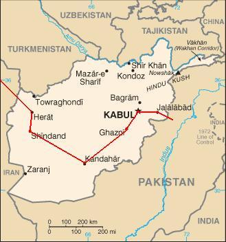
File:Hippie trail.svg[edit]
Greetings. Can you make a small change to this file? In Afghanistan the trail goes from Herat to Kandahar to Kabul (like so) and this is how the road is laid out. So the only change necessary is to remove the line directly from Herat to Kabul. WR 17:18, 30 January 2023 (UTC)
- No problem. NNW 16:49, 3 February 2023 (UTC)
Karte DESY/Hera[edit]
Moin,
https://commons.wikimedia.org/wiki/File:Karte_DESY-PETRA-HERA.png
die Karte ist nicht ganz korrekt, der HERA-Tunnel hat an den Kardinalpunkten gerade Strecken.
MikeTango (talk) 08:23, 4 February 2023 (UTC)
- Moin! Ist geändert. Es wäre wirklich schön, wenn mal nicht nur ein Fehler angemerkt, sondern auch gleichzeitig ein Link auf eine korrekte Quelle gleich mitgeliefert würde. NNW 15:29, 4 February 2023 (UTC)
Maps of ranges of some Sorex and Crocidura[edit]
Thank you for "Range of Crocidura shantungensis" . Yes this is quite different from the IUCN map? because IUCN map is completely wrong. Unfortunately, I know that very well. What do you think about:
- Sorex portenkoi P. 373, Map V, ж - Sorex jacksoni (only Sibirian part without Alaska)
- Crocidura shantungensis P. 382 e - northern border of the range. ???
The main source is [2]. Maps after page 369. Hunu (talk) 20:53, 3 February 2023 (UTC)
- As long as there is a reliable source everything is okay. If a map shows Alaska being distribution area of an animal I don't know why I should not show it. I don’t understand your question to the northern border of Crocidura shantungensis. NNW 16:11, 16 February 2023 (UTC)
Unterschiedliche Lizensen[edit]
Moin, Ich hab angefangen deine Anregung umzusetzen. Nun habe ich das Problem, dass ich 2 Quellen mit unterschiedlichen Lizensen habe, aber beides mal die Weitergabe unter gleichen Bedingungen. Maps for free unter 2.0 und die Possitionskarten unter 3.0. Was zählt jetzt? Siehe z.B. [3] Gruß Peter in s (talk) 06:49, 22 February 2023 (UTC)
![[3]](https://commons.wikimedia.org/wiki/File:Lake_Volta_OSM.png)
- Da nimmt man üblicherweise die mit der höheren Zahl, wobei die Unterschiede bei der rechtlichen Situation hinter den Versionen marginal sind. Die Bedingungen, auf die es ankommt, sind, dass Namensnennung und Weitergabe unter gleichen Bedingungen erhalten bleiben. Die Lizenzbausteine schreiben ja unter der gleichen oder einer kompatiblen Lizenz wie das Original (s. auch [4]). Was nicht geht, wäre bspw. ein Wechsel zu GFDL oder von CC-BY-SA zu CC-BY-NC-SA (NC = non-commercial). NNW 06:57, 22 February 2023 (UTC)
- OK, Merci. Peter in s (talk) 07:05, 22 February 2023 (UTC)
File:Karte Schienennetz Mongolei.svg[edit]
Hallo NordNordWest,
Wenn ich das richtig sehe (aus der Versionsgeschichte bin ich nicht ganz klug geworden), hast Du File:Karte Schienennetz Mongolei.svg (mit)erstellt? Es gibt eine Streckenverlängerung in der Mongolei, siehe: https://de.wikipedia.org/wiki/Bahnstrecke_Sainschand%E2%80%93Khangi (ehemals: Bahnstrecke Sainschand—Dsüünbajan). Kannst Du das auf der Karte nachtragen? -- Reinhard Dietrich (talk) 12:07, 16 March 2023 (UTC)
- Moin! Ja, die Karte ist von mir und ich kann auch grundsätzlich die Strecke einzeichnen, aber ich benötige eine Vorlage für den Verlauf der Strecke. Es reicht bei Karten leider nicht, nur zu wissen, dass etwas existiert, es muss auch verortet sein. Viele Grüße, NNW 12:51, 16 March 2023 (UTC)
@Reinhard Dietrich: Die Strecke ist jetzt eingezeichnet. Viele Grüße, NNW 17:52, 11 June 2023 (UTC)
- @NordNordWest: Herzlichen Dank! -- Reinhard Dietrich (talk) 18:48, 11 June 2023 (UTC)
Location maps[edit]
Hello. Are you familiar with any helpful tutorials how to prepare location maps such as the ones you've done for Croatia on my request? What tools do you use for that? I would like to learn how to do it. Greetings, Mathieu Mars (talk) 14:36, 22 March 2023 (UTC)
- Download OSM data as SVG or PDF (I prefer PDF).
- Open the file in a vector graphics editor like Adobe Illustrator and edit the data: delete what you don't need, merge waterbody areas, bring it to the correct style, perhaps reduce the amount of nodes etc.
- Export the file into a raster graphic file, import it into Google Earth to find out what are the coordinates of the edges.
- Upload a SVG file at Commons.
- That's it. NNW 08:27, 23 March 2023 (UTC)
Maps of Croatian counties[edit]
Thank you so much for the maps of Croatian counties! What about the others? Very necessary. Villarreal9 (talk) 16:31, 25 March 2023 (UTC)
- As soon as I have got more time I will continue. It's not forgotten. NNW 16:37, 25 March 2023 (UTC)
- OK, thank you. I will wait Villarreal9 (talk) 17:34, 25 March 2023 (UTC)
Bahnstrecke Appenweier-Strasbourg auf der Rheintalbahnkarte[edit]
Hallo @NordNordWest,
Ich arbeite derzeit an der französischen Version von diesen beide Artikeln : Bahnstrecke Appenweier–Strasbourg und Bahnstrecke Mannheim–Basel. Wäre es möglich die Bahnstrecke Appenweier–Strasbourg auf deine Karte "Karte Rheintalbahn" zu integrieren ? Ich denke, dass diese Nebenstrecke trotzdem wichtig ist, weil sie der Hauptbahnhof von Strassburg mit der Bahnstrecke Mannheim–Basel verbindet und weil sie auch eines Teils der Magistrale für Europa ist.

(talk) 12:00, 28 March 2023 (UTC)
- Hallo! Ich ahne, zumindest die Kollegen auf de:wp würden das nicht so toll finden, die denken sehr nach Einzelobjekten. Wie wäre es, wenn ich eine französische Version mit beiden Strecken hochlade? NNW 17:24, 28 March 2023 (UTC)
Hello, would like some help[edit]
I'm trying to improve some early Medieval Scottish history topics on en.Wiki. I have put together a map based on one that you made, but it strikes me that you would probably do a much better job. Are you able to help? I can upload my efforts for you to see if it helps. Catfish Jim and the soapdish (talk) 21:12, 29 March 2023 (UTC)
- This is the file: File:Scotland location map.jpg Catfish Jim and the soapdish (talk) 21:21, 29 March 2023 (UTC)
- Hello! I can create a SVG file. You want to keep all modern boundaries? NNW 16:07, 30 March 2023 (UTC)
- Thanks... we could lose the modern boundaries. Catfish Jim and the soapdish (talk) 05:54, 31 March 2023 (UTC)
- Pictiosh kingdom in 7th century.svg. If you want to use a different colour for Scotland (perpaps blue or whatever) you may recolour it. NNW 15:39, 3 April 2023 (UTC)
- Brilliant, thanks so much! Catfish Jim and the soapdish (talk) 16:00, 13 April 2023 (UTC)
- Pictiosh kingdom in 7th century.svg. If you want to use a different colour for Scotland (perpaps blue or whatever) you may recolour it. NNW 15:39, 3 April 2023 (UTC)

|
History of Africa by century has been listed at Commons:Categories for discussion so that the community can discuss ways in which it should be changed. We would appreciate it if you could go to voice your opinion about this at its entry. If you created this category, please note that the fact that it has been proposed for discussion does not necessarily mean that we do not value your kind contribution. It simply means that one person believes that there is some specific problem with it. If the category is up for deletion because it has been superseded, consider the notion that although the category may be deleted, your hard work (which we all greatly appreciate) lives on in the new category. In all cases, please do not take the category discussion personally. It is never intended as such. Thank you! |
- You created Category:History of Asia by century which is included in the discussion. -- Ricky81682 (talk) 20:57, 23 April 2023 (UTC)
Hallo. Auf File:United Kingdom England adm location map.svg ist Torbay nicht als Unitary Authority eingezeichnet. Gruß --Århus (talk) 17:35, 30 April 2023 (UTC)
- Danke für den Hinweis, ist jetzt korrigiert. Viele Grüße, NNW 17:44, 30 April 2023 (UTC)
Dupplin Moor[edit]
Hi NordNordWest,
I do like your map of Dupplin Moor, but unfortunately you have a mistake on it and I certainly cannot fix it! You do have the crossed swords for the battle site in the correct place, but underneath "Perth" you have a dot and the accompanying words supposedly marking the location of the village Burntisland ("Wester Kinghorn").
I am sure this is an oversight. I am not sure why you would want to put Wester Kinghorn on the map, but if you do then it is on the coast due east of Dunfermline. Adrian
Freuchie (talk) 19:29, 6 May 2023 (UTC)
- Hello! I guess you are talking about the map in en:Battle of Dupplin Moor. I just made the background map. The rest is made by en:Template:Location map many. So if you click here you will find all coordinates, symbols and names which are used in the location map and you can edit them all. NNW 19:34, 6 May 2023 (UTC)
Locator map for the Gaza Strip[edit]
Hello,
I noticed that there is no locator map specifically for the Gaza Strip. I'd appreciate it if you'd make one. Festucalex (talk) 05:16, 11 May 2023 (UTC)
Maps request[edit]
Hi, (Also ping @C1MM: ) i found a government link (click on the district names to download, in there you will find the details maps), if you want you can create some maps for Bangladesh (Upazila, union maps) based on that, e.g. something like this. Bangladesh has also 495 Upazilla and 4000+ union. We could use those to wikipedia article. I know it is a big ask but if you can at least create base map (e.g. this one but without red color), i can work base on that. it would be tremendous help. Thank you :) আফতাবুজ্জামান (talk) 19:37, 18 May 2023 (UTC)
.svg)
- Another one from 2016. --আফতাবুজ্জামান (talk) 19:51, 18 May 2023 (UTC)
- Sorry, I won't have the time to do this the next months. NNW 15:53, 19 May 2023 (UTC)
Notification about possible deletion[edit]

|
Some contents have been listed at Commons:Deletion requests so that the community can discuss whether they should be kept or not. We would appreciate it if you could go to voice your opinion about this at their entry.
If you created these pages, please note that the fact that they have been proposed for deletion does not necessarily mean that we do not value your kind contribution. It simply means that one person believes that there is some specific problem with them, such as a copyright issue. Please see Commons:But it's my own work! for a guide on how to address these issues. |
Affected:
Yours sincerely, Lukas Beck (talk) 13:48, 8 June 2023 (UTC)
|
|
File:U-Bahnhof Schippelsweg 5.jpg has been listed at Commons:Deletion requests so that the community can discuss whether it should be kept or not. We would appreciate it if you could go to voice your opinion about this at its entry.
If you created this file, please note that the fact that it has been proposed for deletion does not necessarily mean that we do not value your kind contribution. It simply means that one person believes that there is some specific problem with it, such as a copyright issue. Please see Commons:But it's my own work! for a guide on how to address these issues. |
Lukas Beck (talk) 13:52, 8 June 2023 (UTC)
Notification about possible deletion[edit]
|
|
Some contents have been listed at Commons:Deletion requests so that the community can discuss whether they should be kept or not. We would appreciate it if you could go to voice your opinion about this at their entry.
If you created these pages, please note that the fact that they have been proposed for deletion does not necessarily mean that we do not value your kind contribution. It simply means that one person believes that there is some specific problem with them, such as a copyright issue. Please see Commons:But it's my own work! for a guide on how to address these issues. |
Affected:
And also:
- File:U-Bahnhof Niendorf Nord 3.jpg
- File:U-Bahnhof Niendorf Nord 4.jpg
- File:U-Bahnhof Niendorf Nord 7.jpg
- File:U-Bahnhof Niendorf Nord 8.jpg
- File:U-Bahnhof Niendorf Nord 9.jpg
Yours sincerely, Lukas Beck (talk) 13:59, 8 June 2023 (UTC)
Notification about possible deletion[edit]
|
|
Some contents have been listed at Commons:Deletion requests so that the community can discuss whether they should be kept or not. We would appreciate it if you could go to voice your opinion about this at their entry.
If you created these pages, please note that the fact that they have been proposed for deletion does not necessarily mean that we do not value your kind contribution. It simply means that one person believes that there is some specific problem with them, such as a copyright issue. Please see Commons:But it's my own work! for a guide on how to address these issues. |
Affected:
And also:
Yours sincerely, Lukas Beck (talk) 14:08, 8 June 2023 (UTC)
Update for File:Karte Schienennetz Mongolei.svg[edit]
Hello, I am requesting an update for File:Karte Schienennetz Mongolei.svg. A new rail line from Zuunbayan to Khangi opened on November 25, 2022, per sources at [5] [6]. I had difficulty finding a map from an official source, but I found this on Google Images from Railway Gazette: [7], from [8]. Note: Your map has the Tavantolgoi to Gashuunsukhait line which opened in September 2022, and as depicted in the Railway Gazette map there is a west–east Dalanzadgad to Zuunbayan line expected to open by the end of this year. Excellent work on making this. — Goszei (talk) 23:11, 10 June 2023 (UTC)
- Also: what is the source for the depicted branch line to Tömörtei? I wasn't able to find any information on this. — Goszei (talk) 06:52, 11 June 2023 (UTC)
- OSM shows a rail line which quite sure is the line to Tömörtei. NNW 17:17, 11 June 2023 (UTC)
- https://jargaldefacto.com/article/new-solution-old-hardships seems to be the better map for new rail lines (and for Tömörtei). As OSM already shows the connection Dsüünbajan–Tawan Tolgoi I added it, too. NNW 17:48, 11 June 2023 (UTC)
![[9]](https://mgl.gogo.mn/newsn/np/2022/03/09/5177444/zuunbayan-173009-1205966014.jpeg)
![[10]](https://mgl.gogo.mn/newsn/np/2022/03/09/5177444/zuunbayan_-173013-1953892568.jpeg)
Landesregierungen Österreich[edit]
Hallo NNW, die Karte mit den Landeskoalitionen in Österreich bräuchte wieder eine Aktualisierung, Salzburg auf Schwarz-Blau. Grüße, Chondrocladia (talk) 20:19, 19 June 2023 (UTC)
- Danke für den Hinweis, Landesregierungen in Österreich 06-2023.png ist jetzt da. Viele Grüße, NNW 17:31, 20 June 2023 (UTC)
File: Israel North relief location map 2.png[edit]
Dear NordNordWest,
I'm a French Prehistoric archaeologist working on the Natufian culture of the Levant. If you are interested, here are articles from Germany about my previous work: https://www.nationalgeographic.de/geschichte-und-kultur/2023/06/archaeologie-12000-jahre-alte-floete-klingt-wie-raubvogel-musik-instrument https://www.dw.com/en/how-the-sound-of-music-changed-prehistoric-societies/a-65939873
I'm contacting you about the map you uploaded on Wikipedia : Israel North relief location map 2.png: https://commons.wikimedia.org/wiki/File:Israel_North_relief_location_map_2.png
If you agree, I would like to use it for an Archaeological article that I'm submitting to the Scientific Journal Plos One (https://journals.plos.org/plosone/). I would like to use it as a map to locate the Prehistoric sites we are mentioning in the article.
Could you please contact me by e-mail so that I can send you the form that the journal Plos One sent me?
Here's my e-mail address: laurent.davin.etu[at]gmail.com
Thank you in advance for your reply
Laurent Davin Laurent Davin (talk) 15:54, 9 July 2023 (UTC)
Aosta Valley as an official French-speaking region[edit]
Hi, I would kindly ask you to please add the Aosta Valley on this map, since the French language is official there since 1561. Thanks :) You can reply to me here. Tenam (talk) 16:39, 23 July 2023 (UTC)
- Done. NNW 19:24, 27 July 2023 (UTC)
Herkunftsangabe[edit]
Hallo NordNordWest, schön, dass die Karte bei Wikimedia verfügbar ist. Urheber der Karte ist das Forschungsprojekt Germania Sacra, Niedersächsische Akademie der Wissenschaften zu Göttingen. Es wäre schön, die Urheberschaft der Karte und die Original-URL, von der die Karte kopiert wurde, anzugeben. Das Projekt Germania Sacra veröffentlicht alle seine Daten unter der Lizenz CC-BY-SA 4.0 (https://commons.wikimedia.org/w/index.php?title=File:Di%C3%B6zesankarte_vor_1517.png) Vielen Dank Hilarixx (talk) 11:55, 25 July 2023 (UTC)
- Moin! Die URL ist angegeben, den Rest kann ich gerne ergänzen. Viele Grüße, NNW 12:11, 25 July 2023 (UTC)
Croatian maps[edit]
Hello NordNordWest, is there any chance for a couple of new Croatian maps in a free while? The hitherto maps enriched thousands of articles and have been very useful. If the remaining Croatian maps are supposed to be currently too engaging, maybe there is a chance for maps of 3 main Bosnian subdivisions instead as this country misses any detailed location maps? Greetings, Mathieu Mars (talk) 19:03, 7 August 2023 (UTC)
- Hello! No, it will go on with Croatia. I just needed a break. NNW 19:38, 7 August 2023 (UTC)
- Very appreciated. Mathieu Mars (talk) 19:55, 7 August 2023 (UTC)
Banovina Map 1939-1941[edit]
I was wondering if you could make a map of the Banovinas of the Kingdom of Yugoslavia from 1939-1941 since you made one with the 1929-1939 Banovinas(https://commons.wikimedia.org/wiki/File:Banovinas_of_the_Kingdom_of_Yugoslavia_1929%E2%80%931939.svg) DarkoRatic (talk) 18:09, 22 August 2023 (UTC)
- I don't have a source for that. NNW 07:22, 23 August 2023 (UTC)
- Could this map work as source/reference?
- https://commons.wikimedia.org/wiki/File:Locator_map_Zeta_Banovina_in_Yugoslavia_1939-1941.svg DarkoRatic (talk) 14:07, 24 August 2023 (UTC)
- Well, I had forgotten that I once made Yugoslavia (1939–41) location map.svg. :o) NNW 05:15, 25 August 2023 (UTC)
- Banovinas of the Kingdom of Yugoslavia 1939–1941.svg is available now. NNW 17:10, 25 August 2023 (UTC)
_location_map.svg)
Kreis Nordfriesland[edit]
Do you know if a locator map has been created for Kreis Nordfriesland somewhere? Vedac13 (talk) 08:42, 30 August 2023 (UTC)
- There is Locator map NF in Germany.svg (in Germany) or Schleswig-Holstein NF.svg (in Schleswig-Holstein). NNW 09:05, 30 August 2023 (UTC)
- Thanks. Are there any location maps of the Kreis as well? Vedac13 (talk) 10:59, 30 August 2023 (UTC)
Maps Tansania[edit]
Hi NNW, Du hast dankenswerterweise vor einiger Zeit alle Distrikte in Tansania neu gezeichnet. Laut dem Ergebnis der Volkszählung haben sich folgende Änderungen ergeben (Seite 63): In der Region Morogoro wurde der 2-teilige Distrikt Kilombero "aufgelassen": Der Westteil heißt jetzt Mimba, der Ostteil gehört zu Ifakara Town (TC). Kannst Du das bitte ändern. Danke Friedl 11 (talk) 08:25, 7 September 2023 (UTC)
- Moin! Die Karten zur Region Morogoro und die Übersichtskarte sind alle in neuen 2023er-Versionen hochgeladen. Viele Grüße, NNW 14:24, 7 September 2023 (UTC)
Request for location map creation[edit]
Hi could you create location map for South Ethiopia Regional State? Thanks. 196.191.61.127 20:12, 9 September 2023 (UTC)
- Technically yes but I am quite busy at the moment. NNW 08:56, 10 September 2023 (UTC)
- Well, in addition to this, when you have time, it would be great if you could make a map of Ethiopia including new regions. Thanks. Kehaa (talk) 12:34, 11 September 2023 (UTC)
- The location maps of Ethiopia and the files in Category:SVG locator maps of regions in Ethiopia (location map scheme) are updated now. NNW 17:49, 11 September 2023 (UTC)
- Good work. Thank you! Kehaa (talk) 10:59, 15 September 2023 (UTC)
- The location maps of Ethiopia and the files in Category:SVG locator maps of regions in Ethiopia (location map scheme) are updated now. NNW 17:49, 11 September 2023 (UTC)
- Well, in addition to this, when you have time, it would be great if you could make a map of Ethiopia including new regions. Thanks. Kehaa (talk) 12:34, 11 September 2023 (UTC)
Hirschenhof[edit]
Moin! Du hattest dankenswerterweise die Karte zu de:Hirschenhof (Kolonie) erstellt. Jetzt ist jemandem aufgefallen, dass dort als Name der Kirche Liepen steht. Das Kirchspiel hieß aber Linden. Kannst Du das ändern? Danke -- Agnete (talk) 07:53, 13 September 2023 (UTC)
- Moin! Na klar, ist korrigiert. Viele Grüße, NNW 15:53, 13 September 2023 (UTC)
- Danke!-- Agnete (talk) 16:12, 13 September 2023 (UTC)
World maps[edit]
First of all congratulations for this fantastic work. It's really amazing. Working on a project, I have a question. Is it possible to have the entire world in svg. I "just" need the precisely geolocated shorelines of the entire world. Thanks for your help Corsicansailor (talk) 04:47, 18 October 2023 (UTC)
- Hello! There is Category:SVG maps of the world with lots of maps in several scales/precisions and projections. NNW 11:25, 18 October 2023 (UTC)
- Many thanks. we'll stay in touch if you don't mind. Best Regards Corsicansailor (talk) 11:48, 18 October 2023 (UTC)
Request for update[edit]
Hello NordNordWest, could you update this file?, The file needs update. One region i.e SNNPR after establishment of Sidama region was disintegrated and replaced by three newly established regions such as Southwest Ethiopia People's region, South Ethiopia and Central Ethiopia. Thanks. Kehaa (talk) 17:22, 06 November 2023 (UTC)
- Hello! I think it would be easier to create a completely new SVG file. That would be easier to update for future changes, too. NNW 16:22, 6 November 2023 (UTC)
- Great, creating the new SVG file is so good. Thank you. Kehaa (talk) 17:05, 6 November 2023 (UTC)
Hallo, kannst du bitte auf der Karte File:Karte Leichtathletik-Verband Nordrhein.svg noch die Städte Bottrop, Bocholt und Isselburg hinzufügen. Obwohl sie kommunalpolitisch eigentlich zu Westfalen gehören, sind sie in der LVN Region Nord eingegliedert. Allerdings nur diese Städte, nicht der gesamte Kreis Borken. Hier sieht man es einigermaßen https://archiv.lvnordrhein.de/index.php/der-lvn/kontakte/kreismitarbeiter. Viele Grüße Nordat (talk) 15:50, 6 November 2023 (UTC)
- Moin! Die Karte ist jetzt korrigiert. Viele Grüße, NNW 16:23, 6 November 2023 (UTC)
- Super. Vielen Dank. Ist w:de:Rhede auch drauf? Ist noch östlich von Bocholt. Die Stadt/Gemeinde ist tatsächlich auch noch im LV Nordrhein. File:Rhede in BOR.svg zeigt die Lage. Wenn Rhede noch drin ist, wäre die Nordrhein-Karte vollständig. Nordat (talk) 10:27, 15 November 2023 (UTC)
- Dann hoffe ich mal, dass es jetzt stimmt. NNW 16:27, 15 November 2023 (UTC)
- Ja, vielen Dank Nordat (talk) 15:05, 22 November 2023 (UTC)
- Dann hoffe ich mal, dass es jetzt stimmt. NNW 16:27, 15 November 2023 (UTC)
East African Federation[edit]
Hey NNW, apologies for the bother but since you updated the East African Community map, thought I'd ask about this one as well. The EAC has a separate article called the East African Federation (EAF) and its map still hasn't been updated yet. Here's the link to the svg file for the other (not updated) map. They're mostly the same except for the lack of borders on the latter map. No worries if you're too busy or can't update it but thought I'd let you know in case it helps. Thanks, Dantheanimator (talk) 17:07, 25 November 2023 (UTC)
.svg)
- Hello! No problem, I've updated the map. NNW 17:14, 25 November 2023 (UTC)
- Sorry, I have to revert it. East African Federation ≠ East African Community. NNW 17:18, 25 November 2023 (UTC)
- Thanks for the quick reply! Regarding the two, they are essentially the same (one is a current organization and the other is the proposed/hoped for federation of the members of that organization). The article for the East African Federation lists Somalia as amongst the proposed members and every sources I've seen on the East African Federation defines it as a federation of all the members of the East African Community (which now includes Somalia). Since Somalia's admission is very recent, I haven't found many sources listing Somalia by name but there are a few (here's an article from a former foreign minister of Somalia, for example) that place Somalia as part of the proposed federation. Hopefully this is enough but feel free to let me know if there's something I'm missing or anything else I could to help. Thanks, Dantheanimator (talk) 18:34, 25 November 2023 (UTC)
- I really don't know. I just had a look at the WP articles and there was nothing about Somalia. Perhaps the articles haven't been updated, then revert my revert. NNW 18:35, 25 November 2023 (UTC)
- Hmm interesting. The English wiki one was updated by some user yesterday but I'm not sure about other language wikis. My guess is it'll take a few days time until most of the major wikis update their pages. Btw, I linked the English wiki page in my reply above plus an external WP:RS (in English) in case you want to check them out. I'll revert back to your original update given the sources/comments above. In any case, many thanks for updating the map and for the quick replies! :)
- Best, Dantheanimator (talk) 18:42, 25 November 2023 (UTC)
- I really don't know. I just had a look at the WP articles and there was nothing about Somalia. Perhaps the articles haven't been updated, then revert my revert. NNW 18:35, 25 November 2023 (UTC)
Maps of administrative divisions of Montenegro[edit]
Hello. I wish ask you to do a lot of work with maps of administrative divisions of Montenegro. Since 2023 there are 25 municipalities (opčina) in Montenegro. The newest version of map is this: File:Montenegro, administrative divisions - sq - colored 2022.svg - with Zeta municipality. Can you pleas make new version of files in category: Category:SVG labeled maps of administrative divisions of Montenegro (location map scheme), File:Montenegro adm location map.svg, File:Montenegro adm location map.svg and others? Thank you! Unpocoloco (talk) 15:49, 27 November 2023 (UTC)
- Hello! No problem, I will update the maps. NNW 10:35, 28 November 2023 (UTC)
Elde Karte[edit]
Servus NNW. Ich bin gerade über [Elde Karte] gestolpert und entweder bin ich zu doof, oder die Beschreibung "Elde mit Schleuse" ist wirklich verwirrend, da neben der Elde auch der Elde-Kanal zwischen Eldena und Dömitz und andere Kanalabschnitte hervorgehoben sind. Andererseits ist der zur (markierten) Wasserstraße gehörende Störkanal nicht markiert. Ich weis, in der Namensgebung steckt ne menge Geschichte die es nicht einfacher macht. Raffzahn (talk) 22:46, 30 November 2023 (UTC)
- Moin! Die Elde ist in der Tat kompliziert und die Karte ein Produkt der Zusammenarbeit mit den Artikelerstellern des Elde-Artikels. Die Elde an sich ist heutzutage ab dem Plauer See der Kanal (Müritz-Elde-Wasserstraße). Die ehemaligen Flussverläufe, die parallel dazu noch hier und da existieren, sind nur noch Überbleibsel. Der Einfachheit halber sind hier alle zusammengefasst als "Elde". Da der Störkanal aus dem Schweriner See kommt, ist er ein Zufluss zur Elde und nicht hervorgehoben. NNW 07:18, 1 December 2023 (UTC)
Map data - Norwegian county maps 2024[edit]
Hi,
I was just looking at your new maps of the Norwegian counties from 2024, and wondered where the map data came from, and what format you use to get it into a program that can create SVGs. Quite interested in hearing from you. Worldlydev (talk) 22:59, 3 December 2023 (UTC)
- Hello! They base on Norway adm location map.svg which use VMAP0 and WDBII data. Some of the boundaries are taken from my private data as a cartographer. All data was transferred to Illustrator using Shapefiles. NNW 06:44, 4 December 2023 (UTC)
- Where did you get the VMAP0 and WDBII data? Worldlydev (talk) 12:10, 4 December 2023 (UTC)
- WDBII e.g. at https://www.evl.uic.edu/pape/data/WDB/. For VMAP see the links at en:Vector Map#External links. NNW 12:14, 4 December 2023 (UTC)