Category:Renfrewshire
ナビゲーションに移動
検索に移動
Traditional counties (shires) of Scotland:Aberdeenshire · Angus · Argyll ≈ Argyllshire · Ayrshire · Banffshire · Berwickshire · Buteshire · Caithness · Clackmannanshire · Cromartyshire · Dumbartonshire · Dumfriesshire · East Lothian · Fife · Inverness-shire · Kincardineshire · Kinross-shire · Kirkcudbrightshire · Lanarkshire · Midlothian · Moray · Nairnshire · the Orkney Islands ≈ Orkney Islands · Peeblesshire · Perthshire · Renfrewshire · Ross-shire · Roxburghshire · Selkirkshire · the Shetland Islands ≈ Shetland Islands · Stirlingshire · Sutherland · West Lothian · Wigtownshire
Council areas (municipalities) of Scotland: Aberdeen · Aberdeenshire · Angus · Argyll and Bute · Clackmannanshire · Dumfries and Galloway · Dundee · East Ayrshire · East Dunbartonshire · East Lothian · East Renfrewshire · Edinburgh · Falkirk · Fife · Glasgow · Highland · Inverclyde · Midlothian · Moray · North Ayrshire · North Lanarkshire · Outer Hebrides · Orkney Islands · Perth and Kinross · Renfrewshire · Scottish Borders · Shetland Islands · South Ayrshire · South Lanarkshire · Stirling · West Dunbartonshire · West Lothian
スコットランドの州   | |||||
| メディアをアップロード | |||||
| 分類 | |||||
|---|---|---|---|---|---|
| 以下の一部分 |
| ||||
| 場所 | スコットランド | ||||
| 行政中心地 | |||||
| 人口 |
| ||||
| 面積 |
| ||||
| 公式ウェブサイト | |||||
 | |||||

下位カテゴリ
このカテゴリに属する 27 個のサブカテゴリのうち、 27 個を表示しています。
*
A
- Aerial photographs of Renfrewshire (49ファイル)
B
- Barr Loch water pump (5ファイル)
- Broomknowe Farm (5ファイル)
C
E
G
H
I
L
N
P
- Panoramics of Renfrewshire (27ファイル)
S
T
V
カテゴリ「Renfrewshire」にあるメディア
このカテゴリに属する 188 個のファイルのうち、 188 個を表示しています。
-
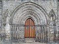 13th century west door of Paisley Abbey, Renfrewshire. - panoramio.jpg 3,648 × 2,736;4.73メガバイト
-

-

-
 A Meeting Of Two Rivers - geograph.org.uk - 3660365.jpg 4,592 × 3,448;4.45メガバイト
-
 A View Near Glasgow Airport - panoramio.jpg 3,072 × 2,304;1.66メガバイト
-
 Babcock sunrise - geograph.org.uk - 6022281.jpg 1,024 × 574;106キロバイト
-
 Babcock sunrise - geograph.org.uk - 6022283.jpg 1,024 × 569;99キロバイト
-
 Barnsford Bridge - geograph.org.uk - 3660314.jpg 4,592 × 3,448;3.73メガバイト
-
 Barnsford Road - geograph.org.uk - 5893161.jpg 1,024 × 647;224キロバイト
-
 Beside the Clyde - geograph.org.uk - 4979891.jpg 1,024 × 768;301キロバイト
-
 Beside the White Cart Water - geograph.org.uk - 5925690.jpg 1,024 × 768;216キロバイト
-
 Black Cart Water - geograph.org.uk - 2746520.jpg 640 × 392;85キロバイト
-
 Black Cart Water - geograph.org.uk - 2746523.jpg 640 × 382;77キロバイト
-
 Black Cart Water - geograph.org.uk - 4978921.jpg 1,024 × 768;184キロバイト
-
 Black Cart Water - geograph.org.uk - 5893152.jpg 1,024 × 556;271キロバイト
-
 Black Cart Water - geograph.org.uk - 5893163.jpg 1,024 × 559;234キロバイト
-
 Black Cart Water - geograph.org.uk - 6456758.jpg 1,024 × 768;334キロバイト
-
 Black Cart Water - geograph.org.uk - 6475012.jpg 1,024 × 495;215キロバイト
-
 Black Cart Water - geograph.org.uk - 6477046.jpg 1,024 × 387;156キロバイト
-
 Black Cart Water Railway Bridge - geograph.org.uk - 3564473.jpg 2,560 × 1,920;1.15メガバイト
-
 Black Cart Water seen from Barnsford Bridge - geograph.org.uk - 3606094.jpg 1,024 × 768;115キロバイト
-
 Black Cart Water Upstream Of Barnsford Bridge - geograph.org.uk - 3660322.jpg 4,592 × 3,448;4.07メガバイト
-
 Blackstoun Road Black Cart Water Bridge - geograph.org.uk - 3798596.jpg 853 × 1,280;952キロバイト
-
 Boden Boo Plantation, Erskine, Renfrewshire.jpg 1,920 × 1,080;759キロバイト
-
 Bodinbo Island and training dike to the left, Erskine, Renfrewshire.jpg 1,920 × 1,080;598キロバイト
-
 Bodinbo Island at low tide, Erskine, Renfrewshire.jpg 1,920 × 1,080;888キロバイト
-
 Brookfield Village Hall, Renfrewshire.jpg 4,128 × 1,956;2.74メガバイト
-
 Candrens and Boghead from the air - geograph.org.uk - 2071748.jpg 2,592 × 1,944;2.6メガバイト
-
 Chinese lantern in the mud - geograph.org.uk - 5258486.jpg 640 × 480;132キロバイト
-
 Clyde Estuary - geograph.org.uk - 2017664.jpg 640 × 480;107キロバイト
-
 Clyde View - geograph.org.uk - 2419591.jpg 640 × 480;76キロバイト
-
 Coat of Arms of Renfrewshire.svg 267 × 397;176キロバイト
-
 Cobbles on site of supposed Roman Causeway - geograph.org.uk - 1941967.jpg 1,024 × 768;302キロバイト
-
 Country Life, Bishopton, Renfrewshire. - panoramio.jpg 4,000 × 3,000;3.96メガバイト
-
 Cow at Black Cart Water - geograph.org.uk - 6477042.jpg 1,024 × 683;374キロバイト
-

-

-

-
 Doon The Watter - 25th June 2011 , Approaching Bowling Basin - geograph.org.uk - 2644846.jpg 1,600 × 1,200;387キロバイト
-

-
 Doon The Watter - 25th June 2011 , Dumbuck Perch - geograph.org.uk - 2489153.jpg 1,600 × 1,200;182キロバイト
-

-
 Doon The Watter - 25th June 2011 , Rotting Hulks At Bowling - geograph.org.uk - 2644920.jpg 1,600 × 1,200;435キロバイト
-

-

-
 Dumbarton Castle - geograph.org.uk - 3452133.jpg 4,242 × 2,339;2.72メガバイト
-
 Dumbuck Perch Light - geograph.org.uk - 5682451.jpg 1,024 × 640;129キロバイト
-
 Dumbuck Quarry - geograph.org.uk - 3452115.jpg 4,320 × 2,432;2.64メガバイト
-
 Dumbuck Quarry - geograph.org.uk - 6101018.jpg 1,024 × 652;321キロバイト
-
 Dumbuck Quarry - geograph.org.uk - 6101021.jpg 1,024 × 768;358キロバイト
-
 Dumbuck Quarry - geograph.org.uk - 6249061.jpg 1,024 × 565;235キロバイト
-
 Dumbuck Quarry - geograph.org.uk - 6249071.jpg 1,024 × 513;185キロバイト
-
 Dumbuckhill Quarry and the River Clyde - geograph.org.uk - 5726407.jpg 640 × 391;108キロバイト
-
 Erskine Bridge from Erskine ferry beach, Renfrewshire.jpg 1,920 × 1,080;602キロバイト
-
 Erskine Ferry, old gates at entrance, Renfrewshire.jpg 1,920 × 1,080;1.09メガバイト
-
 Erskine from the air (geograph 4542697).jpg 640 × 395;110キロバイト
-
 Erskine Lodge from Erskine ferry beach, Renfrewshire.jpg 1,920 × 1,080;745キロバイト
-
 Erskine Looking Towards Clydebank - panoramio.jpg 3,072 × 2,304;2.1メガバイト
-
 Farming near Westferry - geograph.org.uk - 3566349.jpg 640 × 301;64キロバイト
-
 Ferry Dock - geograph.org.uk - 5769463.jpg 640 × 417;115キロバイト
-
 Footbridge and River at Blackstone Mains - geograph.org.uk - 2419638.jpg 640 × 434;97キロバイト
-
 Former ROF Bishopton from the air - geograph.org.uk - 2600819.jpg 640 × 480;134キロバイト
-
 Freeway and Dumbuckhill Quarry - geograph.org.uk - 4979007.jpg 1,024 × 768;297キロバイト
-
 Garrison Perch Light Beacon - geograph.org.uk - 3060985.jpg 640 × 480;82キロバイト
-
 Gate - panoramio (3).jpg 4,592 × 2,576;6.42メガバイト
-
 Grain lift pulley, Millbank Mill, Lochwinnoch, Renfrewshire.jpg 4,604 × 3,452;5.52メガバイト
-
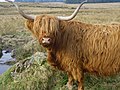 Highland Cattle, Gleniffer Braes Country Park, Renfrewshire. (so cute) - panoramio.jpg 4,000 × 3,000;4.13メガバイト
-

-
 Highland Cattle, Gleniffer Braes Country Park, Renfrewshire. - panoramio.jpg 4,000 × 3,000;4.01メガバイト
-
 Housing at Linwood (geograph 4508807).jpg 3,264 × 2,448;4.53メガバイト
-
 Howwood, Renfrewshire.jpg 4,128 × 1,956;2.84メガバイト
-
 Island in the Black Cart Water - geograph.org.uk - 3950215.jpg 640 × 480;61キロバイト
-
 King's Inch and the Pudzeoch Basin, Renfrew Ferry, Renfrewshire.jpg 4,896 × 2,752;2.06メガバイト
-
 Laid-up aircraft at Glasgow Airport - geograph.org.uk - 6463898.jpg 1,024 × 475;203キロバイト
-
 Laid-up aircraft at Glasgow Airport - geograph.org.uk - 6463900.jpg 1,024 × 527;205キロバイト
-
 Langbank East crannog and Dumbarton Rock - geograph.org.uk - 6101003.jpg 1,024 × 649;297キロバイト
-
 Looking across the River Clyde towards Dumbarton - geograph.org.uk - 3628165.jpg 1,024 × 768;170キロバイト
-
 Low Spring tide on the Clyde - geograph.org.uk - 4394453.jpg 1,024 × 682;185キロバイト
-
 Low tide on the River Clyde at Bishopton, Renfrewshire. - panoramio.jpg 4,000 × 3,000;4.13メガバイト
-
 Low tide on the River Clyde at Langbank, Renfrewshire. - panoramio.jpg 4,000 × 3,000;5.52メガバイト
-
 M8 gantry sign near Junction 29 - geograph.org.uk - 6151344.jpg 1,024 × 537;205キロバイト
-
 Main Door, Thomas Coates Memorial Church, Paisley, Renfrewshire. - panoramio.jpg 4,224 × 3,168;3.32メガバイト
-
 Main Street, Houston, Renfrewshire (geograph 5906206).jpg 1,024 × 573;220キロバイト
-
 Mar Hall Hotel, Bishopton, Renfrewshire. - panoramio.jpg 3,750 × 2,695;942キロバイト
-
 Measured Milepost in the Clyde at Parklea - geograph.org.uk - 5258437.jpg 640 × 411;131キロバイト
-
 Middleton Farm from the air - geograph.org.uk - 2071738.jpg 2,592 × 1,944;2.54メガバイト
-
 Millbank Burn Bridge, upstream side, Lochwinnoch.jpg 4,608 × 3,456;3.55メガバイト
-
 Millbank Burn Mill Bridge & Burn, Lochwinnoch, Renfrewshire.jpg 4,608 × 3,456;6.91メガバイト
-
 Millbank Mill lane, Lochwinnoch - old railway over the access lane.jpg 4,356 × 3,088;4.49メガバイト
-
 Millbank Mill lane, Lochwinnoch, Renfrewshire - view towards Millbank Burn Bridge.jpg 4,598 × 3,442;6.56メガバイト
-
 Millbank Mill ruins, Lochwinnoch - mill dam.jpg 4,608 × 3,456;5.24メガバイト
-
 Mudflats at Finlaystone Burn - geograph.org.uk - 5258049.jpg 640 × 345;133キロバイト
-
 Muirshiel Country Park, Lochwinnoch, Renfrewshire. - panoramio.jpg 2,496 × 1,872;1.64メガバイト
-
 Navigation beacon in the Clyde - geograph.org.uk - 3566270.jpg 640 × 554;118キロバイト
-
 New green beacon on the Lang Dyke - geograph.org.uk - 5682486.jpg 1,024 × 768;149キロバイト
-
 Old ceramic insulator in the mud - geograph.org.uk - 5258549.jpg 640 × 480;151キロバイト
-
 Old Erskine ferry slipway, Renfrewshire.jpg 1,920 × 1,080;672キロバイト
-
 Old industrial land from the air - geograph.org.uk - 6231781.jpg 1,024 × 768;331キロバイト
-
 Our dog Deva on the Gleniffer Braes, Paisley, Renfrewshire - panoramio.jpg 4,000 × 3,000;3.72メガバイト
-
 Path beside the White Cart Water - geograph.org.uk - 5929012.jpg 1,024 × 768;250キロバイト
-
 Path beside the White Cart Water - geograph.org.uk - 5929021.jpg 1,024 × 768;246キロバイト
-
 Path to Porterfield Road - geograph.org.uk - 5929016.jpg 1,024 × 768;325キロバイト
-
 Phoenix Retail Park (geograph 4958285).jpg 3,264 × 2,448;3.59メガバイト
-
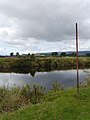 Poles By The Black Cart Water - geograph.org.uk - 3660352.jpg 3,448 × 4,592;3.17メガバイト
-
 POND - panoramio.jpg 4,592 × 2,576;4.07メガバイト
-
 Port Glasgow timber ponds - geograph.org.uk - 5543375.jpg 640 × 480;146キロバイト
-
 Posts on the shore - geograph.org.uk - 5392018.jpg 1,024 × 768;135キロバイト
-
 Private jet at Glasgow Airport - geograph.org.uk - 5893158.jpg 1,024 × 657;281キロバイト
-
 Question mark in the Clyde - geograph.org.uk - 5258543.jpg 640 × 578;184キロバイト
-
 Question mark in the Clyde - geograph.org.uk - 5258546.jpg 640 × 424;150キロバイト
-
 Radar tower at Glasgow Airport - geograph.org.uk - 5893153.jpg 1,024 × 768;236キロバイト
-
 Remains of timber ponds - geograph.org.uk - 4979956.jpg 1,024 × 768;289キロバイト
-
 Renfrewshire Council 2017.svg 360 × 185;4キロバイト
-
 Renfrewshire Map.png 4,967 × 4,967;6.78メガバイト
-
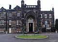
 Renfrewtownhall.jpg 2,448 × 3,264;2.03メガバイト
-
 River Clyde - geograph.org.uk - 2400096.jpg 640 × 330;91キロバイト
-
 River Clyde - geograph.org.uk - 3175439.jpg 1,600 × 1,200;543キロバイト
-
 River Clyde - geograph.org.uk - 3783116.jpg 640 × 480;50キロバイト
-
 River Clyde and Kilpatrick Hills - geograph.org.uk - 2326373.jpg 640 × 480;119キロバイト
-
 River Clyde view towards Dumbarton Rock - geograph.org.uk - 2419588.jpg 640 × 480;80キロバイト
-
 Road sign - panoramio (1).jpg 4,592 × 2,576;4.12メガバイト
-
 Rural shops - panoramio.jpg 4,592 × 2,576;3.55メガバイト
-
 Scotland Renfrewshire Council 2022.svg 360 × 185;4キロバイト
-
 Sea defences at Langbank - geograph.org.uk - 5258513.jpg 640 × 480;166キロバイト
-
 Shoreline, West Ferry - geograph.org.uk - 4979881.jpg 1,024 × 768;421キロバイト
-
 Slip road to M8 at junction 31 eastbound - geograph.org.uk - 2419601.jpg 640 × 480;98キロバイト
-
 Small headland near Westferry - geograph.org.uk - 6101016.jpg 1,024 × 675;359キロバイト
-
 Spreading fast car - panoramio.jpg 4,592 × 2,576;3.78メガバイト
-
 Spring Tulip with Raindrops. - panoramio.jpg 640 × 480;276キロバイト
-
 St Patrick Light & Rock, Erskine Bridge & the River Clyde, Erskine.jpg 1,920 × 1,080;565キロバイト
-
 St Patrick's & Donald's Quay Lights on the River Clyde, Erskine.jpg 1,920 × 1,080;884キロバイト
-
 St Patrick's Rock & Light, River Clyde - low tide.jpg 1,920 × 1,080;1,012キロバイト
-
 Standing Stones on the Gleniffer Braes, Paisley, Renfrewshire. - panoramio.jpg 4,000 × 3,000;4.15メガバイト
-
 The Black Cart Water - geograph.org.uk - 3948857.jpg 3,264 × 2,448;3.01メガバイト
-
 The Black Cart Water - geograph.org.uk - 3948860.jpg 3,264 × 2,448;4.04メガバイト
-
 The Black Cart Water - geograph.org.uk - 4602350.jpg 3,264 × 2,448;3.7メガバイト
-
 The Black Cart Water-Gryfe Water Confluence - geograph.org.uk - 3660355.jpg 3,448 × 4,592;3.44メガバイト
-
 The Clyde between Renfrew and Yoker - geograph.org.uk - 2926940.jpg 3,264 × 2,448;3.73メガバイト
-
 The Clyde Estuary at West Ferry car park - geograph.org.uk - 2017658.jpg 640 × 480;104キロバイト
-
 The Clyde, Dumbarton and Ben Lomond - geograph.org.uk - 2191582.jpg 640 × 338;70キロバイト
-
 The Erskine Bridge, Renfrewshire. - panoramio.jpg 4,000 × 3,000;4.14メガバイト
-
 The Longhaugh Light - geograph.org.uk - 1941032.jpg 768 × 1,024;153キロバイト
-
 The M8 crosses the Black Cart Water - geograph.org.uk - 4509567.jpg 3,264 × 2,448;2.76メガバイト
-
 The old Park Quay basin, River Clyde, Erskine.jpg 1,920 × 1,080;1.19メガバイト
-
 The old pig house, Erskine Estate, Bishopton, Renfrewshire. - panoramio.jpg 3,648 × 2,736;2.47メガバイト
-
 The Phoenix and Elderslie from the air - geograph.org.uk - 6231789.jpg 1,024 × 695;412キロバイト
-
 The River Clyde and Ben Lomond - geograph.org.uk - 6103375.jpg 1,024 × 595;192キロバイト
-
 The River Clyde and Bowling - geograph.org.uk - 2326370.jpg 640 × 480;118キロバイト
-
 The River Clyde and Milton - geograph.org.uk - 6103379.jpg 1,024 × 768;370キロバイト
-
 The sea wall at Finlaystone - geograph.org.uk - 5258417.jpg 640 × 480;179キロバイト
-
 The sea wall at Finlaystone - geograph.org.uk - 5258418.jpg 640 × 480;214キロバイト
-
 The sea wall at Finlaystone - geograph.org.uk - 5258421.jpg 640 × 480;182キロバイト
-
 The sea wall at Finlaystone - geograph.org.uk - 5258429.jpg 640 × 480;158キロバイト
-
 The Upper Clyde from the air - geograph.org.uk - 2565743.jpg 640 × 480;167キロバイト
-
 The Waverly Makes Her Way Up The Clyde - panoramio.jpg 1,825 × 948;846キロバイト
-
 The White Cart Water - geograph.org.uk - 2926888.jpg 3,264 × 2,448;3.04メガバイト
-
 Thomas Coates Memorial Church, Paisley, Renfrewshire. - panoramio.jpg 4,224 × 3,168;3.21メガバイト
-
 Timber pond heron - geograph.org.uk - 5258459.jpg 640 × 480;156キロバイト
-
 Timber pond heron - geograph.org.uk - 5258465.jpg 640 × 435;157キロバイト
-
 Timber ponds and Dumbarton Rock - geograph.org.uk - 5258358.jpg 640 × 480;151キロバイト
-
 Timber ponds and Dunglass Castle - geograph.org.uk - 5258356.jpg 640 × 480;115キロバイト
-
 Timber ponds at Langbank - geograph.org.uk - 5257021.jpg 640 × 480;110キロバイト
-
 Timber ponds at Langbank - geograph.org.uk - 5258425.jpg 640 × 480;166キロバイト
-
 Timber ponds at Langbank - geograph.org.uk - 5258431.jpg 640 × 480;157キロバイト
-
 Timber ponds at Langbank - geograph.org.uk - 5258435.jpg 640 × 377;119キロバイト
-
 Timber ponds at Langbank - geograph.org.uk - 5258448.jpg 640 × 480;147キロバイト
-
 Timber ponds at Langbank - geograph.org.uk - 5258454.jpg 480 × 640;178キロバイト
-
 Timber ponds at Langbank - geograph.org.uk - 5258481.jpg 640 × 480;152キロバイト
-
 Timber ponds at Langbank - geograph.org.uk - 5258523.jpg 640 × 408;117キロバイト
-
 Timber ponds at Langbank - geograph.org.uk - 5258529.jpg 640 × 480;155キロバイト
-
 Timber ponds at Langbank - geograph.org.uk - 5258556.jpg 640 × 424;154キロバイト
-
 Timber ponds at Langbank - geograph.org.uk - 5258557.jpg 480 × 640;179キロバイト
-
 Timber ponds at Langbank - geograph.org.uk - 5258559.jpg 640 × 480;169キロバイト
-
 Timber ponds at Langbank - geograph.org.uk - 5258579.jpg 640 × 480;141キロバイト
-
 Timber ponds at Langbank - geograph.org.uk - 5258586.jpg 640 × 480;169キロバイト
-
 Timber ponds at Parklea - geograph.org.uk - 5258441.jpg 640 × 396;128キロバイト
-
 Timber ponds near Langbank - geograph.org.uk - 5323564.jpg 640 × 336;73キロバイト
-
 Timber ponds near Langbank - geograph.org.uk - 5323569.jpg 640 × 333;82キロバイト
-
 Timber ponds near Langbank - geograph.org.uk - 5323578.jpg 640 × 351;111キロバイト
-
 Turn - panoramio.jpg 4,592 × 2,576;4.92メガバイト
-
 Two people with cart - panoramio.jpg 4,592 × 2,576;3.59メガバイト
-
 View across River Clyde towards Bowling - geograph.org.uk - 3903708.jpg 5,184 × 3,456;7.26メガバイト
-
 View of Green Road in car.jpg 2,268 × 4,032;2.32メガバイト
-

-
 West Renfrewshire from the air - geograph.org.uk - 3026204.jpg 640 × 416;80キロバイト
-
 West Renfrewshire from the air - geograph.org.uk - 3026267.jpg 640 × 480;90キロバイト
-
 Wildflowers in Spring - panoramio.jpg 2,048 × 1,536;1.09メガバイト
-
 Wildflowers, Lochwinnoch, Renfrewshire. - panoramio.jpg 3,648 × 2,736;2.47メガバイト

.jpg)


._Publication_date_1915.png)
._Publication_date_1898.png)
_on_Renfrewshire,_Sheet_XII_(incl._Eastwood,_Neilston,_Paisley)._Publication_date_1864.jpg)


.jpg)


.jpg)

_-_panoramio.jpg)
_-_panoramio.jpg)

.jpg)


.jpg)


.jpg)


.jpg)


