Category:Dumfriesshire
Jump to navigation
Jump to search
Traditional counties (shires) of Scotland: Aberdeenshire · Angus · Argyll ≈ Argyllshire · Ayrshire · Banffshire · Berwickshire · Buteshire · Caithness · Clackmannanshire · Cromartyshire · Dumbartonshire · Dumfriesshire · East Lothian · Fife · Inverness-shire · Kincardineshire · Kinross-shire · Kirkcudbrightshire · Lanarkshire · Midlothian · Moray · Nairnshire · the Orkney Islands ≈ Orkney Islands · Peeblesshire · Perthshire · Renfrewshire · Ross-shire · Roxburghshire · Selkirkshire · the Shetland Islands ≈ Shetland Islands · Stirlingshire · Sutherland · West Lothian · Wigtownshire
historic county of Scotland  | |||||
| Upload media | |||||
| Instance of |
| ||||
|---|---|---|---|---|---|
| Location |
| ||||
| Capital | |||||
| Population |
| ||||
 | |||||
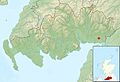
Dumfriesshire is a shire county of Scotland in en:Dumfries and Galloway. It now only exists for ceremonial and land registration purposes, and in the name of some local organisations.
Subcategories
This category has the following 6 subcategories, out of 6 total.
Media in category "Dumfriesshire"
The following 88 files are in this category, out of 88 total.
-
 Burns in Dumfriesshire- a sketch of the last eight years of the poet's life (IA acm8846.0001.001.umich.edu).pdf 750 × 1,070, 90 pages; 6.15 MB
-
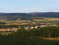
 Amisfield sa chiardh.jpg 960 × 708; 117 KB
-

-
 Bankend - Allmhurach 01.jpg 3,104 × 1,746; 2.24 MB
-
 Barr na Drise - Allmhurach.jpg 2,076 × 1,745; 702 KB
-
 Beattock bho shuas.jpg 960 × 730; 53 KB
-
 Brow hamlet, Dumfries & Galloway, Scotland.jpg 4,608 × 2,746; 4.17 MB
-
 Brow Well and Bridge, Dumfries & Galloway.jpg 4,400 × 3,158; 6.82 MB
-
 Brow Well, Burn and Bridge, Dumfries & Galloway.jpg 4,400 × 2,882; 4.35 MB
-
 Chapelcross may 2019.jpg 4,834 × 3,222; 1.34 MB
-
 Clarencefield - Allmhurach 01.jpg 3,104 × 1,746; 2.5 MB
-
 Clarencefield allmhurach.jpg 2,388 × 1,742; 1.26 MB
-
 Collin, allmhurach.jpg 2,360 × 1,707; 1.19 MB
-
 Comar na Drise - Allmhurach 01.jpg 3,104 × 1,746; 2.18 MB
-
 Daltan allmhurach 02.jpg 2,645 × 1,746; 1.33 MB
-
 Dubhras na Doire.jpg 2,231 × 1,745; 518 KB
-
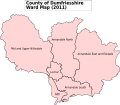 Dumfriesshire C Ward Map 2011.svg 1,033 × 901; 222 KB
-
 Dumfriesshire Map.png 4,967 × 4,967; 6.8 MB
-
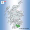
 Dumfriesshire.png 2,095 × 2,351; 173 KB
-
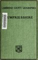 Dumfriesshire (IA dumfriesshire00hewi).pdf 700 × 1,104, 196 pages; 8.4 MB
-

-
 Hightae.jpg 960 × 667; 71 KB
-
 Logarbaidh allmhurach.jpg 2,430 × 1,742; 581 KB
-
 Mapa dg am magh fada.jpg 2,004 × 1,363; 599 KB
-
 Mapa dg amisfield.jpg 2,004 × 1,363; 599 KB
-
 Mapa dg applegarthtown.jpg 2,004 × 1,363; 599 KB
-
 Mapa dg auldgirth.jpg 2,004 × 1,363; 599 KB
-
 Mapa dg baile na h-eaglaise.jpg 2,004 × 1,363; 599 KB
-
 Mapa dg bankend.jpg 2,004 × 1,363; 599 KB
-
 Mapa dg beattock.jpg 2,004 × 1,363; 599 KB
-
 Mapa dg bentpath.jpg 2,004 × 1,363; 599 KB
-
 Mapa dg bàrr na dris.jpg 2,004 × 1,363; 599 KB
-
 Mapa dg canonbie.jpg 2,004 × 1,363; 599 KB
-
 Mapa dg cathair ruaidh.jpg 2,004 × 1,363; 599 KB
-
 Mapa dg cathair.jpg 2,004 × 1,363; 599 KB
-
 Mapa dg chapelknowe.jpg 2,004 × 1,363; 599 KB
-
 Mapa dg cill osbairn.jpg 2,004 × 1,363; 599 KB
-
 Mapa dg cille bhrìghde.jpg 2,004 × 1,363; 599 KB
-
 Mapa dg cille chonaill.jpg 2,004 × 1,363; 599 KB
-
 Mapa dg cille phàdraig nam fleamach.jpg 2,004 × 1,363; 599 KB
-
 Mapa dg clarencefield.jpg 2,004 × 1,363; 599 KB
-
 Mapa dg collin.jpg 2,004 × 1,363; 599 KB
-
 Mapa dg comar na drise.jpg 2,004 × 1,363; 599 KB
-
 Mapa dg cuingealach.jpg 2,004 × 1,363; 599 KB
-
 Mapa dg dalswinton.jpg 2,004 × 1,363; 599 KB
-
 Mapa dg daltan.jpg 2,004 × 1,363; 599 KB
-
 Mapa dg doras na frìthe.jpg 2,004 × 1,363; 599 KB
-
 Mapa dg drochaid a' mhuillinn.jpg 2,004 × 1,363; 599 KB
-
 Mapa dg drochaid charrainn.jpg 2,004 × 1,363; 599 KB
-
 Mapa dg drochaid mhic iain.jpg 2,004 × 1,363; 599 KB
-
 Mapa dg duncow.jpg 2,004 × 1,363; 599 KB
-
 Mapa dg dòrnach.jpg 2,004 × 1,363; 599 KB
-
 Mapa dg dùn sgoir.jpg 2,004 × 1,363; 599 KB
-
 Mapa dg eaglais fheichein.jpg 2,004 × 1,363; 599 KB
-
 Mapa dg eaglesfield.jpg 2,004 × 1,363; 599 KB
-
 Mapa dg eastriggs.jpg 2,004 × 1,363; 599 KB
-
 Mapa dg eskdalemuir.jpg 2,004 × 1,363; 599 KB
-
 Mapa dg gleann chapall.jpg 2,004 × 1,363; 599 KB
-
 Mapa dg hightae.jpg 2,004 × 1,363; 599 KB
-
 Mapa dg hoddom.jpg 2,004 × 1,363; 599 KB
-
 Mapa dg holywood.jpg 2,004 × 1,363; 599 KB
-
 Mapa dg inbhir anainn.jpg 2,004 × 1,363; 599 KB
-
 Mapa dg kettleholm.jpg 2,004 × 1,363; 599 KB
-
 Mapa dg kirtlebridge.jpg 2,004 × 1,363; 599 KB
-
 Mapa dg langaim.jpg 2,004 × 1,363; 599 KB
-
 Mapa dg loch mhabain.jpg 2,004 × 1,363; 599 KB
-
 Mapa dg logarbaidh.jpg 2,004 × 1,363; 599 KB
-
 Mapa dg mouswald.jpg 2,004 × 1,363; 599 KB
-
 Mapa dg parkgate.jpg 2,004 × 1,363; 599 KB
-
 Mapa dg penpont.jpg 2,004 × 1,363; 599 KB
-
 Mapa dg ruthwell.jpg 2,004 × 1,363; 599 KB
-
 Mapa dg templand.jpg 2,004 × 1,363; 599 KB
-
 Mapa dg torthorwald.jpg 2,004 × 1,363; 599 KB
-
 Mapa dg tynron.jpg 2,004 × 1,363; 599 KB
-
 Mapa dg wamphray.jpg 2,004 × 1,363; 599 KB
-
 Mouswald, allmhurach a.jpg 2,218 × 1,745; 442 KB
-
 Roe Buck (40974159041).jpg 3,334 × 2,223; 4.81 MB
-
 RosefeildMill DumfriseStonecarvingProject GrantMcintosh (8 of 18).jpg 2,480 × 1,654; 753 KB
-
 Ruadhail - Allmhurach 01.jpg 3,104 × 1,746; 2.4 MB
-
 Ruthwell Church & Churchyard, Dumfries & Galloway.jpg 4,520 × 2,779; 3.7 MB
-
 Ruthwell Church outbuilding, Dumfries & Galloway.jpg 4,608 × 3,456; 8.59 MB
-
 Ruthwell Church, Dumfries & Galloway.jpg 4,588 × 3,430; 4.79 MB
-
 Ruthwell Churchyard gravestones, Dumfries & Galloway.jpg 4,608 × 3,456; 6.56 MB
-
 Ruthwell Churchyard, Dumfries & Galloway.jpg 4,570 × 3,406; 7.05 MB
-
 Ruthwell Cross, Ruthwell Church, Dumfries & Galloway.jpg 4,608 × 3,456; 3.67 MB
-
 Ruthwell Manse, Dumfries & Galloway.jpg 4,599 × 3,000; 6.56 MB
-
 The birds of Dumfriesshire BHL48038505.jpg 2,473 × 3,845; 524 KB
-
 William West Neve - Glenluiart, Moniaive, Dumfriesshire, 1901.jpg 590 × 380; 110 KB


.jpg)


.jpg)
.jpg)


