Category:Sutherland
Jump to navigation
Jump to search
Traditional counties (shires) of Scotland: Aberdeenshire · Angus · Argyll ≈ Argyllshire · Ayrshire · Banffshire · Berwickshire · Buteshire · Caithness · Clackmannanshire · Cromartyshire · Dumbartonshire · Dumfriesshire · East Lothian · Fife · Inverness-shire · Kincardineshire · Kinross-shire · Kirkcudbrightshire · Lanarkshire · Midlothian · Moray · Nairnshire · the Orkney Islands ≈ Orkney Islands · Peeblesshire · Perthshire · Renfrewshire · Ross-shire · Roxburghshire · Selkirkshire · the Shetland Islands ≈ Shetland Islands · Stirlingshire · Sutherland · West Lothian · Wigtownshire


historic county, lieutenancy area and registration county of Scotland     | |||||
| Upload media | |||||
| Instance of |
| ||||
|---|---|---|---|---|---|
| Part of | |||||
| Location | |||||
| Capital | |||||
| Population |
| ||||
 | |||||
Subcategories
This category has the following 122 subcategories, out of 122 total.
A
- Achany (44 F)
- Achentoul (14 F)
- Achiemore (3 F)
- Achiemore, Durness (5 F)
- Achinduich (21 F)
- Achnacarnin (9 F)
- Achuvoldrach (1 F)
- Ardachu (4 F)
- Arkle (hill) (46 F)
- Aultiphurst (1 F)
B
- Balchladich (12 F)
- Ben Griam Beg (8 F)
- Ben Hee (9 F)
- Ben Hope (49 F)
- Ben Hutig (13 F)
- Ben Stack (50 F)
- Loch nam Brac (4 F)
C
- Carn Liath, Golspie (29 F)
- Cinn Trolla Broch (7 F)
- Crask, Lairg (68 F)
- Croick Church (9 F)
D
- Dalreavoch (2 F)
E
- Eas a' Chual Aluinn (12 F)
- Evelix (24 F)
F
- Fanagmore (15 F)
- Farr, Sutherland (16 F)
- Farrmheall (17 F)
G
H
I
K
- Kirtomy (5 F)
- Kyle of Durness (65 F)
L
- Leckfurin (11 F)
- Linsidemore (2 F)
- Loch Ailsh (9 F)
- Loch Airigh na Beinne (5 F)
- Loch Bealach a' Bhuirich (4 F)
- Loch Borralan (10 F)
- Loch Cracail Mór (5 F)
P
- Pittentrail (17 F)
- Portgower (12 F)
- Portskerra (9 F)
- Proncycroy (4 F)
- Pulrossie (24 F)
S
- Sallachy Broch (3 F)
- Sangobeg (36 F)
- Saval (6 F)
- Sgribhis-bheinn (25 F)
- Skullomie (34 F)
- Srath na Seilge (5 F)
- Strath Brora, Sutherland (5 F)
- Strath Dionard (59 F)
- Strath Melness (4 F)
- Suilven (132 F)
- Swordly (4 F)
T
- Talmine, Sutherland (28 F)
- Telford Bridge, The Mound (10 F)
- Thurso Castle (18 F)
- Trantlebeg (36 F)
U
- Upper Bighouse (4 F)
W
- West Langwell (45 F)
Media in category "Sutherland"
The following 200 files are in this category, out of 1,320 total.
(previous page) (next page)-
 "Path" Allt Bad an t-Sagairt - geograph.org.uk - 213904.jpg 640 × 480; 109 KB
-
 "Strath- Navernia = Strath-Navern - Auct. Timotheo Pont" (21636337084).jpg 3,618 × 3,036; 2.09 MB
-

-
 A Bridge on the Allt na Drochaidean Beag - geograph.org.uk - 119269.jpg 640 × 480; 113 KB
-
 A Broch at Tirryside near Loch Shin - geograph.org.uk - 78952.jpg 640 × 480; 113 KB
-
 A Broch at Tirryside near Loch Shin - geograph.org.uk - 78957.jpg 640 × 480; 108 KB
-
 A Broch in Strath Tollaidh - geograph.org.uk - 420083.jpg 640 × 480; 112 KB
-
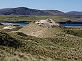
 A Burnt Mound near Loch Farlary - geograph.org.uk - 62219.jpg 640 × 480; 143 KB
-
 A Cottage on Borrobol Estate - geograph.org.uk - 347544.jpg 444 × 640; 62 KB
-
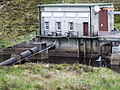
 A Fish Ladder on the Strath Carnaig River - geograph.org.uk - 453331.jpg 640 × 480; 247 KB
-
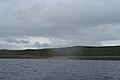
 A Lot of Lochs and Lochans - Flickr - Graham Grinner Lewis.jpg 3,648 × 2,736; 2.56 MB
-

-
 A Shoreline crawl towards the Airde. - geograph.org.uk - 189051.jpg 640 × 427; 45 KB
-
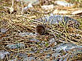 A Shrew - geograph.org.uk - 202061.jpg 640 × 480; 125 KB
-
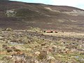 A small herd of cattle, or "some coos" - geograph.org.uk - 1338362.jpg 640 × 480; 111 KB
-
 A Small Wood in Glencassley - geograph.org.uk - 85861.jpg 640 × 480; 94 KB
-
 A Snowy Cnoc Mor in Glencassley - geograph.org.uk - 85875.jpg 640 × 480; 90 KB
-
 A Snowy Footpath To Carn nam Bo Maola - geograph.org.uk - 85873.jpg 640 × 480; 102 KB
-
 A Tree and a Old Croft Ruin at Rhian - geograph.org.uk - 70325.jpg 640 × 480; 94 KB
-
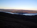
 A view from Beinn Clach an Fheadain - geograph.org.uk - 83209.jpg 640 × 480; 65 KB
-
 A view from Beinn Clach an Fheadain - geograph.org.uk - 83211.jpg 640 × 480; 33 KB
-
 A view from Beinn Clach an Fheadain - geograph.org.uk - 83212.jpg 640 × 480; 26 KB
-
 A view from Beinn Clach an Fheadain - geograph.org.uk - 83213.jpg 640 × 480; 40 KB
-
 A view from Beinn Clach an Fheadain - geograph.org.uk - 83215.jpg 640 × 480; 87 KB
-
 A view from Beinn Clach an Fheadain - geograph.org.uk - 83223.jpg 640 × 480; 80 KB
-
 A view from Beinn Clach an Fheadain - geograph.org.uk - 83228.jpg 640 × 480; 98 KB
-
-
 AA plaque at Struie viewpoint in 1986 - geograph.org.uk - 260439.jpg 640 × 480; 91 KB
-
 Abandoned fishing station - geograph.org.uk - 238166.jpg 640 × 480; 94 KB
-

-
 Abhainn a Choire (River) - geograph.org.uk - 557369.jpg 640 × 480; 93 KB
-
 Achininver Beach - geograph.org.uk - 369961.jpg 640 × 480; 71 KB
-
 Achnairn, Sutherland - geograph-4212301.jpg 1,600 × 1,067; 578 KB
-
 Achuil Cottage hidden in the woods - geograph.org.uk - 49839.jpg 640 × 480; 129 KB
-
 Aird da Loch Peninsula - geograph.org.uk - 189579.jpg 640 × 384; 92 KB
-
 Along the north shore at Aodann Mhòr - geograph.org.uk - 417756.jpg 640 × 480; 104 KB
-
 An Dubh-loch - geograph.org.uk - 657362.jpg 640 × 426; 67 KB
-
 An Fharaid - geograph.org.uk - 782908.jpg 640 × 279; 48 KB
-
 An Garbh-allt - geograph.org.uk - 382376.jpg 640 × 488; 116 KB
-
 An Garbh-allt - geograph.org.uk - 382380.jpg 640 × 467; 94 KB
-
 Approaching Culmaily from the south. - geograph.org.uk - 226499.jpg 640 × 426; 115 KB
-
 April Showers - Sutherland Style^ - geograph.org.uk - 90057.jpg 640 × 480; 89 KB
-
 Atlantic roundhouse Feranach.JPG 2,272 × 1,704; 837 KB
-
 B871 road and River Helmsdale - geograph.org.uk - 505091.jpg 640 × 480; 69 KB
-
 Badcall Bay July 1966 - geograph.org.uk - 704415.jpg 500 × 386; 32 KB
-
 Bagh a Phollain, Sutherland - geograph.org.uk - 868250.jpg 640 × 480; 72 KB
-
 Balnakeil Bay - geograph.org.uk - 1440614.jpg 640 × 422; 48 KB
-
 Balnakeil Bay - geograph.org.uk - 602997.jpg 640 × 326; 31 KB
-
 Balnakeil Bay - geograph.org.uk - 691534.jpg 640 × 480; 48 KB
-
 Balnakeil Bay and beach - geograph.org.uk - 437425.jpg 640 × 427; 53 KB
-
 Balnakeil Bay and Faraid Head - geograph.org.uk - 821831.jpg 640 × 212; 101 KB
-
 Balnakeil Bay and Faraid Head - geograph.org.uk - 834070.jpg 640 × 411; 206 KB
-
 Balnakeil Bay sand dunes - geograph.org.uk - 703461.jpg 640 × 480; 42 KB
-

-
 Barn near Shebster - geograph.org.uk - 550208.jpg 640 × 480; 88 KB
-
 Ben Armine Stables - geograph.org.uk - 635973.jpg 640 × 360; 54 KB
-
 Ben Klibreck - geograph.org.uk - 395309.jpg 640 × 505; 133 KB
-
 Ben Klibreck - geograph.org.uk - 396967.jpg 640 × 480; 144 KB
-
 Ben Loyal - geograph.org.uk - 393430.jpg 640 × 535; 125 KB
-

-
 Ben Stack from Creagan Meall Horn - geograph.org.uk - 759287.jpg 640 × 480; 60 KB
-
 Black ^ Gold - Flickr - jack spellingbacon.jpg 1,600 × 1,200; 585 KB
-
 Bleak moorland - geograph.org.uk - 657555.jpg 640 × 426; 74 KB
-
 Bridge at Forsinain - geograph.org.uk - 577870.jpg 640 × 480; 93 KB
-
 Bridge on Struie road - geograph.org.uk - 18607.jpg 458 × 296; 47 KB
-
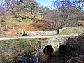 Bridge over burn on the A839 - geograph.org.uk - 704605.jpg 640 × 480; 531 KB
-
 Broch - Druim Chuibhe - geograph.org.uk - 296657.jpg 640 × 429; 98 KB
-
 Bus stop at Strathy - geograph.org.uk - 620070.jpg 640 × 619; 123 KB
-
 By the A 839 - geograph.org.uk - 704228.jpg 640 × 480; 459 KB
-
 Cambusavie - geograph.org.uk - 231558.jpg 640 × 424; 95 KB
-
 Cambusmore Lodge - geograph.org.uk - 1193081.jpg 640 × 481; 165 KB
-
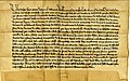
 Charter by David II confirming charter to Nicholas Sutherland 17th Oct 1362.jpg 1,085 × 765; 351 KB
-
-
 Clais Bhuidhe, Sea Cave. - geograph.org.uk - 702045.jpg 640 × 427; 94 KB
-
 Clematis montana Rubens 508957761.jpg 2,592 × 1,952; 2.04 MB
-
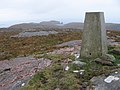 Cnoc Poll a' Mhurain trig point - geograph.org.uk - 425903.jpg 640 × 480; 121 KB
-

-
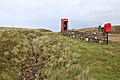 Communication at Lednagullin, Sutherland - geograph-5816924.jpg 1,600 × 1,067; 448 KB
-
 Coomb Island - geograph.org.uk - 226562.jpg 640 × 480; 116 KB
-
 Corner of forest - geograph.org.uk - 492085.jpg 640 × 480; 126 KB
-
 County Council of Sutherland plaque - geograph.org.uk - 485012.jpg 640 × 480; 65 KB
-
 Cul Mhor, Sutherland, Scotland, 15 April 2011 - Flickr - PhillipC.jpg 4,288 × 2,848; 1.97 MB
-
 Curling at Sutherland CC.jpg 1,077 × 807; 228 KB
-
 Daill House, Balnakeil Bay - geograph.org.uk - 497384.jpg 640 × 480; 106 KB
-
 Dalnessie - geograph.org.uk - 504082.jpg 640 × 480; 63 KB
-
 Deer at Badanloch - geograph.org.uk - 545661.jpg 640 × 480; 65 KB
-
 Deer departing, Glen Cassley - geograph.org.uk - 657666.jpg 640 × 458; 510 KB
-
 Dilapidated sheepfold with posing sheep^ - geograph.org.uk - 1680068.jpg 2,048 × 1,536; 958 KB
-
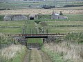
 Disused jetties at Achuvoldrach - geograph.org.uk - 25669.jpg 640 × 480; 76 KB
-
 Disused quarry, Badninish - geograph.org.uk - 274954.jpg 597 × 400; 105 KB
-

-
 Dornaigil.jpg 960 × 960; 99 KB
-
-
 Drumbeg to Kylesku road, Sutherland, Scotland, 14 April 2011 - Flickr - PhillipC.jpg 4,288 × 2,848; 2.17 MB
-
 Duchally Weir - geograph.org.uk - 322436.jpg 640 × 480; 131 KB
-
 Duchally Weir - geograph.org.uk - 322443.jpg 640 × 480; 116 KB
-
 Dunrobin Woods - geograph.org.uk - 296670.jpg 441 × 640; 121 KB
-
 East Sutherland and Edderton.png 885 × 1,300; 240 KB
-
 Easter near Crask - geograph.org.uk - 737643.jpg 640 × 480; 327 KB
-
 Easter snow, Crask - geograph.org.uk - 737659.jpg 640 × 480; 340 KB
-
 Eye manna - geograph.org.uk - 1424028.jpg 640 × 480; 135 KB
-
 Fantastic Rock - geograph.org.uk - 83950.jpg 640 × 480; 119 KB
-

-
 Farm buildings - geograph.org.uk - 490472.jpg 640 × 480; 123 KB
-
 Farm buildings on hillock - geograph.org.uk - 490732.jpg 640 × 480; 110 KB
-
 Final destination of a fairground folly - geograph.org.uk - 1424531.jpg 640 × 480; 139 KB
-
 Flag of Sutherland (2018).svg 800 × 480; 16 KB
-
 Flag of Sutherland.svg 900 × 540; 420 bytes
-
 Fly Agaric - geograph.org.uk - 236109.jpg 640 × 480; 368 KB
-
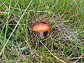 Fly Agaric - geograph.org.uk - 236114.jpg 640 × 480; 409 KB
-

-
 Foinaven - Flickr - Graham Grinner Lewis.jpg 3,648 × 2,736; 2.57 MB
-
 Fomes fomentarius - geograph.org.uk - 189323.jpg 640 × 480; 348 KB
-
 Fomes fomentarius - geograph.org.uk - 189327.jpg 640 × 480; 269 KB
-
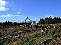 Forestry machine picking up the timber - geograph.org.uk - 238260.jpg 640 × 480; 313 KB
-

-
 Fungi - geograph.org.uk - 236105.jpg 640 × 480; 392 KB
-
 Garden gate^ - geograph.org.uk - 490729.jpg 640 × 480; 119 KB
-
 Glacial Erratics - geograph.org.uk - 704646.jpg 640 × 466; 27 KB
-
 Glencoul Thrust - geograph.org.uk - 9032.jpg 640 × 453; 280 KB
-
 Glendhu House ca 1933 Agfacolor - geograph.org.uk - 83647.jpg 640 × 615; 145 KB
-
 Gobernuisgeach - geograph.org.uk - 74326.jpg 454 × 296; 48 KB
-
 Gull in flight (414788879).jpg 1,001 × 643; 283 KB
-
 Highlands ,Sutherland.jpg 480 × 362; 36 KB
-
 Hillside towards Loch Eas na Maoile - geograph.org.uk - 425156.jpg 640 × 480; 162 KB
-
 Hope - geograph.org.uk - 453395.jpg 2,088 × 1,415; 978 KB
-
 Infrequently used forest track - geograph.org.uk - 452713.jpg 600 × 450; 163 KB
-
 Inselbergs - geograph.org.uk - 217514.jpg 640 × 480; 101 KB
-
 Karibik in Schottland (Durness).JPG 4,752 × 3,168; 3.88 MB
-
 Keifer Sutherland (2105763535).jpg 1,565 × 1,037; 454 KB
-
 Kiosk at Garie Beach (3489770267).jpg 416 × 244; 48 KB
-
 Land erosion at bend in River Borgie - geograph.org.uk - 496415.jpg 640 × 480; 136 KB
-
 Laxford Bay Fishing Hut - geograph.org.uk - 45166.jpg 640 × 480; 71 KB
-

-
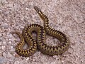 Loch Shin adder.JPG 2,052 × 1,539; 1.02 MB
-
 Lonely road - geograph.org.uk - 82567.jpg 640 × 422; 45 KB
-
 Lonely telephone, Sutherland, Scotland, April 2011 - Flickr - PhillipC.jpg 4,288 × 2,848; 2.23 MB
-
 Looking down on the causeway - geograph.org.uk - 9893.jpg 431 × 576; 67 KB
-
 Looking towards Meall na Leitreach - geograph.org.uk - 45053.jpg 640 × 480; 72 KB
-
 Lothbeg beach, facing South West - geograph.org.uk - 184254.jpg 640 × 481; 139 KB
-
 Mackay of Aberach Family Tree.jpg 848 × 800; 74 KB
-
 Mackay of Scoury coat of arms.jpg 470 × 485; 72 KB
-
-
 Midfield Beach - geograph.org.uk - 618759.jpg 640 × 480; 63 KB
-
 Midtown - geograph.org.uk - 161454.jpg 640 × 480; 86 KB
-
 Mill - geograph.org.uk - 44429.jpg 640 × 480; 186 KB
-
 Moorland at Badninish - geograph.org.uk - 296370.jpg 597 × 400; 78 KB
-
 Mouth of the Tutim Burn.jpg 2,684 × 2,009; 2.91 MB
-
 Mushroom - geograph.org.uk - 236099.jpg 640 × 480; 291 KB
-
 Mushroom - geograph.org.uk - 236101.jpg 640 × 480; 303 KB
-
 Mushroom - geograph.org.uk - 236118.jpg 640 × 480; 335 KB
-
 Mushroom - geograph.org.uk - 236123.jpg 640 × 480; 376 KB
-
 National cycle route 1 - geograph.org.uk - 158563.jpg 640 × 480; 107 KB
-
 New road above Navidale - geograph.org.uk - 149318.jpg 640 × 480; 314 KB
-
 North from Stoer Point, Sutherland, Scotland, 14 April 2011 - Flickr - PhillipC.jpg 4,288 × 2,848; 2.45 MB
-
 Northbound Bikers on the A9. - geograph.org.uk - 226894.jpg 640 × 426; 92 KB
-
 Northern Constabulary - Scotland - Helmsdale officer and police car CM42 - 1984.jpg 1,308 × 1,014; 97 KB
-

-
 Oldshoremore Bay - Flickr - Graham Grinner Lewis.jpg 3,648 × 2,736; 2.56 MB
-
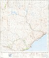 Ordnance Survey One-Inch Sheet 15 Helmsdale, Published 1958.jpg 8,239 × 9,896; 8.22 MB
-
 Ordnance Survey One-Inch Sheet 22 Dornoch, Published 1958.jpg 8,229 × 9,867; 8.55 MB
-
 Peat Patterns - geograph.org.uk - 562817.jpg 640 × 480; 80 KB
-
 Peat Stacks near Glen Cottage - geograph.org.uk - 539692.jpg 640 × 480; 136 KB
-
 Port Hacking River (2798269029).jpg 419 × 493; 78 KB
-
 Post box, Midtown - geograph.org.uk - 164333.jpg 640 × 480; 93 KB
-
 Post Office at Airdtorrisdale.jpg 640 × 480; 118 KB
-
 Private John Thompson (6441380419).jpg 578 × 800; 55 KB
-
 Rabbit Islands - geograph.org.uk - 485983.jpg 640 × 480; 36 KB
-
 Railway Bridge - geograph.org.uk - 574380.jpg 640 × 480; 106 KB
-
 Ramsgate Chief Constable Roderick Ross.jpg 2,589 × 3,945; 859 KB
-
 Red deer - geograph.org.uk - 604647.jpg 640 × 480; 107 KB
-
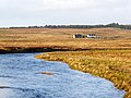
 River Borgie - geograph.org.uk - 165998.jpg 640 × 480; 128 KB
-
 River Halladale - geograph.org.uk - 427998.jpg 640 × 480; 55 KB
-
 River Laxford near Laxford Bridge - geograph.org.uk - 472064.jpg 640 × 480; 71 KB
-
 River Tirry - geograph.org.uk - 662722.jpg 640 × 480; 445 KB
-
 River Tirry Islet - geograph.org.uk - 548233.jpg 640 × 427; 102 KB
-
 River Tirry Towards Blarbuie Cottages - geograph.org.uk - 548232.jpg 640 × 427; 120 KB
-
 Road and Rail - geograph.org.uk - 238225.jpg 640 × 480; 88 KB
-
 Road and rail along the Firth. - geograph.org.uk - 232741.jpg 640 × 426; 68 KB
-
 Road Junction - geograph.org.uk - 58693.jpg 640 × 480; 125 KB
-
 Royal National Park, Audley (2733891141).jpg 613 × 469; 143 KB
-
 Sand dunes backing Balnakeil Bay - geograph.org.uk - 417795.jpg 640 × 480; 105 KB
-
 Sands of Loch Fleet and Sutherland monument.jpg 547 × 380; 35 KB
-
 Sandside Bay - geograph.org.uk - 240306.jpg 640 × 480; 63 KB
-
 Sgt Alexander Will - Sutherland Constabulary 1930s (8339912312).jpg 3,023 × 1,856; 559 KB
-
 Sheep grazing - geograph.org.uk - 505016.jpg 640 × 480; 84 KB
-
 Sheepfold near the Allt a' Phuill - geograph.org.uk - 957305.jpg 640 × 480; 57 KB
-
 Sika does, Glen Cassley - geograph.org.uk - 657685.jpg 640 × 456; 485 KB
-
 Snow at Strath Ousdale - geograph.org.uk - 149393.jpg 640 × 480; 306 KB
-
 Stone stripes - geograph.org.uk - 217522.jpg 640 × 480; 136 KB
-
 Strath Dionard - geograph.org.uk - 237517.jpg 640 × 480; 89 KB
-
 Strath Dionard - geograph.org.uk - 424379.jpg 640 × 480; 163 KB
-
 Strathmore River.png 9,017 × 2,289; 47.31 MB
-
 StrathnaverTrail.jpg 1,047 × 3,259; 526 KB
-
 Strathoykel at Tuiteam Tarbhach.jpg 2,866 × 2,144; 2.66 MB
-
 Strathy Bay - geograph.org.uk - 226783.jpg 640 × 480; 40 KB
-
 Suisgill.jpg 640 × 479; 104 KB
-
 Sutherland CC.jpg 1,077 × 807; 267 KB
-
 Sutherland District Council Achievement.png 354 × 611; 80 KB
-
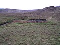
 Sutherland Flow Country.jpg 640 × 480; 59 KB

.jpg)


_-_geograph.org.uk_-_753417.jpg)


_-_geograph.org.uk_-_557369.jpg)


.svg)


.jpg)


.JPG)
.jpg)
.jpg)


.jpg)


.jpg)


.jpg)


.jpg)


.jpg)


