File:Invasions of the Roman Empire 1.png
Aller à la navigation
Aller à la recherche

Taille de cet aperçu : 800 × 566 pixels. Autres résolutions : 320 × 226 pixels | 640 × 453 pixels | 1 024 × 724 pixels | 1 280 × 905 pixels | 1 954 × 1 382 pixels.
Fichier d’origine (1 954 × 1 382 pixels, taille du fichier : 269 kio, type MIME : image/png)
Légendes
Légendes
Ajoutez en une ligne la description de ce que représente ce fichier
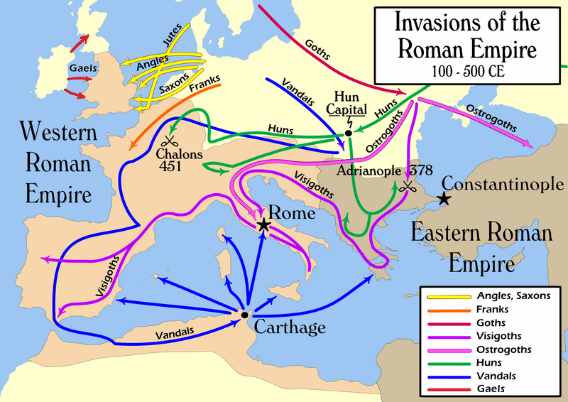
Map of invasions of the Roman state, simplified, AD centuries 2nd to 6th.
Description
[modifier]| Description |
English: Map of the "barbarian" invasions by the Angles, Saxons, Jutes, Franks, Goths, Visigoths, Ostrogoths, Huns and Vandals of the Roman Empire showing the major incursions from 100 to 500 CE.
|
|||
| Date | ||||
| Source | Travail personnel | |||
| Auteur | User:MapMaster | |||
| Autres versions |
[]
|


Conditions d’utilisation
[modifier]
Moi, en tant que détenteur des droits d’auteur sur cette œuvre, je la publie sous la licence suivante :
Ce fichier est disponible selon les termes de la licence Creative Commons Attribution – Partage dans les Mêmes Conditions 2.5 Générique
- Vous êtes libre :
- de partager – de copier, distribuer et transmettre cette œuvre
- d’adapter – de modifier cette œuvre
- Sous les conditions suivantes :
- paternité – Vous devez donner les informations appropriées concernant l'auteur, fournir un lien vers la licence et indiquer si des modifications ont été faites. Vous pouvez faire cela par tout moyen raisonnable, mais en aucune façon suggérant que l’auteur vous soutient ou approuve l’utilisation que vous en faites.
- partage à l’identique – Si vous modifiez, transformez, ou vous basez sur cette œuvre, vous devez distribuer votre contribution sous la même licence ou une licence compatible avec celle de l’original.
Historique du fichier
Cliquer sur une date et heure pour voir le fichier tel qu'il était à ce moment-là.
| Date et heure | Vignette | Dimensions | Utilisateur | Commentaire | |
|---|---|---|---|---|---|
| actuel | 14 février 2022 à 21:08 | | 1 954 × 1 382 (269 kio) | SKIBLY101 (d | contributions) | add the scotti |
| 9 janvier 2022 à 03:36 |  | 1 954 × 1 362 (127 kio) | Jul059 (d | contributions) | Lossless file size reduction | |
| 26 février 2014 à 16:07 |  | 1 954 × 1 362 (139 kio) | Capmo (d | contributions) | cropped very minor white margin | |
| 17 juillet 2007 à 08:35 |  | 1 962 × 1 374 (139 kio) | Nihad Hamzic (d | contributions) | Removed alpha channel, what enabled me to losslessly reduce color domain to 8-bit. The result is a much, much smaller file. If alpha channel is indeed needed, then just revert the actual image to the one which I had previously uploaded (around 480 KB). | |
| 16 juillet 2007 à 10:48 |  | 1 962 × 1 374 (488 kio) | Nihad Hamzic (d | contributions) | Further reduced image size by losslessly optimising PNG compression type. This image's color domain could be reduced to 8-bit if alpha channel was removed, resulting in enormous image size reducion. Is alpha channel really needed here? | |
| 31 octobre 2006 à 19:27 |  | 1 962 × 1 374 (624 kio) | MapMaster (d | contributions) | Smaller, with some corrections and improvements | |
| 21 octobre 2006 à 15:17 |  | 1 959 × 1 398 (603 kio) | MapMaster (d | contributions) | Improved version | |
| 19 octobre 2006 à 21:35 |  | 1 961 × 1 405 (602 kio) | MapMaster (d | contributions) | I corrected the "Huns" route on this map, and am attempting to uploaded a 50% smaller version (Kbyte-wise). | |
| 2 octobre 2006 à 01:35 |  | 3 948 × 2 827 (1,28 Mio) | MapMaster (d | contributions) | uploaded improved map | |
| 1 octobre 2006 à 18:27 |  | 3 944 × 2 814 (1,04 Mio) | MapMaster (d | contributions) | Map of the "barbarian" invasions of the Roman Empire |
Vous ne pouvez pas remplacer ce fichier.
Utilisations locales du fichier
Les 55 pages suivantes utilisent ce fichier :
- Atlas of Albania
- Atlas of Algeria
- Atlas of Austria
- Atlas of Belgium
- Atlas of Bosnia and Herzegovina
- Atlas of Croatia
- Atlas of European history
- Atlas of Galicia
- Atlas of Germany
- Atlas of Greece
- Atlas of Hungary
- Atlas of Italy
- Atlas of Kosovo
- Atlas of Luxembourg
- Atlas of Malta
- Atlas of Montenegro
- Atlas of Morocco
- Atlas of North Macedonia
- Atlas of Portugal
- Atlas of Serbia
- Atlas of Slovenia
- Atlas of Spain
- Atlas of Tunisia
- Atlas of Turkey
- Atlas of ancient Rome
- Atlas of the Byzantine Empire
- Atlas of the Netherlands
- Atlas of the United Kingdom
- Atlas of the antiquity
- Maps of Switzerland
- User:MapMaster
- User:Minorax/SVG available/2022 February 8-14
- User:Minorax/SVG available/2022 January 7-12
- User talk:MapMaster
- File:Folkevandringene.jpg
- File:Grandes invasions Empire romain-eu.svg
- File:Grandes invasions Empire romain-fr.svg
- File:Grandes invasions Empire romain-sh.svg
- File:Grandes invasions Empire romain-sr.svg
- File:Invasi bangsa barbar ke Romawi.svg
- File:Invasiones bárbaras Imperio romano-es.svg
- File:Invasiones bárbares Imperiu romanu.svg
- File:Invasioni dell'Impero Romano.png
- File:Invasions of the Roman Empire.svg
- File:Invasions of the Roman Empire 1.png
- File:Invasions of the Roman Empire Arabic.png
- File:Invasions of the Roman Empire Arabic.svg
- File:Invasions of the Roman Empire Dutch.svg
- File:Invasions of the Roman Empire Greek.png
- File:Invasions of the Roman Empire hu.svg
- File:Invasions of the Roman Empire la.svg
- File:对罗马帝国的入侵.png
- Template:Other versions/Invasions of the Roman Empire
- Category:Maps of Migration period
- Category:Migration period
Utilisations du fichier sur d’autres wikis
Les autres wikis suivants utilisent ce fichier :
- Utilisation sur ar.wikipedia.org
- Utilisation sur azb.wikipedia.org
- Utilisation sur az.wikipedia.org
- Utilisation sur ba.wikipedia.org
- Utilisation sur be-tarask.wikipedia.org
- Utilisation sur be.wikipedia.org
- Utilisation sur bg.wikipedia.org
- Utilisation sur ckb.wikipedia.org
- Utilisation sur csb.wikipedia.org
- Utilisation sur cs.wikipedia.org
- Utilisation sur da.wikipedia.org
- Utilisation sur de.wikipedia.org
- Utilisation sur de.wikibooks.org
- Utilisation sur diq.wikipedia.org
- Utilisation sur el.wikipedia.org
- Utilisation sur en.wikipedia.org
- Civilization
- Germanic peoples
- History of Europe
- Ostrogoths
- Roman Empire
- History of Austria
- History of Bulgaria
- History of Tunisia
- Ancient history
- Migration Period
- Barbarian
- Seeress (Germanic)
- Western Roman Empire
- Ancient Rome
- Early Middle Ages
- Fall of the Western Roman Empire
- Talk:Attila/Archive 2
- Chernyakhov culture
- Roman Gaul
Voir davantage sur l’utilisation globale de ce fichier.