Category:Punjab, India
Jump to navigation
Jump to search

Indian state   someja satełitar in disenbre  .svg)  | |||||
| Upload media | |||||
| Instance of | |||||
|---|---|---|---|---|---|
| Part of | |||||
| Named after | |||||
| Location | India | ||||
| Capital | |||||
| Legislative body |
| ||||
| Executive body |
| ||||
| Official language | |||||
| Head of state |
| ||||
| Head of government |
| ||||
| Inception |
| ||||
| Population |
| ||||
| Area |
| ||||
| Replaces |
| ||||
| Different from | |||||
| official website | |||||
 | |||||
English: Punjab (Punjabi: ਪੰਜਾਬ) is a Sikh majority state in northwest India. The Indian state borders the Pakistani province of Punjab to the west, Jammu and Kashmir to the north, Himachal Pradesh to the northeast, Haryana to the south and southeast and Rajasthan to the southwest. The total area of the state is 50,362 square kilometres (19,445 square miles). The population is 24,289,296 (2000). Punjab's capital is Chandigarh, which is administered separately as a Union Territory since it is also the capital of neighbouring Haryana. Other major cities of Punjab include Mohali, Ludhiana, Amritsar, Patiala and Jalandhar. The Indian Punjab historically forms a part of the larger en:Punjab region, which includes the Pakistani province of Punjab and the North-West Frontier Province, the Indian states of Haryana and Himachal Pradesh, parts of Jammu and Kashmir and the Union Territory of Chandigarh. en:East Punjab was trifurcated in the year 1966 leading to the formation of Haryana and Himachal Pradesh. Eastern Punjab has a very active and popular independence movement, called Khalistan.
Subcategories
This category has the following 19 subcategories, out of 19 total.
Pages in category "Punjab, India"
The following 2 pages are in this category, out of 2 total.
Media in category "Punjab, India"
The following 31 files are in this category, out of 31 total.
-
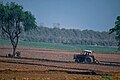 A Farmer Cultivating In Punjab.jpg 3,936 × 2,624; 11.27 MB
-
 EAST PUNJAB PRINCELY STATES PNG BLANK.png 7,500 × 7,500; 2.82 MB
-
 Gurudwara shri guru teg bahadur ji, village Dugal kalan.jpg 4,624 × 2,080; 3.13 MB
-
 Harnam Singh Dhumma.jpg 740 × 529; 52 KB
-
 ISS030-E-16834 - View of India.jpg 4,288 × 2,848; 1.44 MB
-
 Livestock and landscape of Punjab,India.JPG 4,608 × 3,456; 6.23 MB
-
 MANI967.jpg 3,024 × 4,032; 1.9 MB
-

-
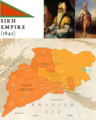 Map of Sikh Empire (1845).png 4,000 × 5,000; 11.84 MB
-
 Posting Chart of Additional Inspectors General of PHP.png 422 × 785; 729 KB
-
 Posting Chart.gif 382 × 712; 168 KB
-
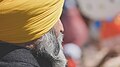 Punjabi Beard.jpg 4,240 × 2,384; 6.48 MB
-
 Sath ,village Dugal Kalan ,district patiala.jpg 4,624 × 2,080; 1.74 MB
-
 Shiromani Akali Dal (Amritsar) Flag.png 2,225 × 1,668; 909 KB
-
 Sub Mountainous landscape of Punjab ,India.jpg 960 × 369; 114 KB
-
 ਆਯੁਰਵੈਦਿਕ ਡਿਸਪੈਂਸਰੀ.jpg 4,000 × 2,250; 2.95 MB
-
 ਕੋਸ ਮੀਨਾਰ.jpg 2,250 × 4,000; 2.81 MB
-
 ਗੁੱਗਾ ਮਾੜੀ 2.jpg 4,000 × 2,250; 3.64 MB
-
 ਗੁੱਗਾ ਮਾੜੀ 3.jpg 2,250 × 4,000; 3.47 MB
-
 ਗੁੱਗਾ ਮਾੜੀ.jpg 4,000 × 2,250; 4.72 MB
-
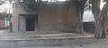
 ਡਾਕਘਰ.jpg 4,000 × 2,250; 2.96 MB
-
 ਡੇਰਾ ਬਾਬਾ ਜੱਗਾ ਜੀ ਪਿੰਡ ਘੜੂੰਆਂ.jpg 2,250 × 4,000; 2.91 MB
-
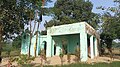
 ਪੰਚਾਇਤ ਘਰ.jpg 4,000 × 2,250; 3.49 MB
-
 ਸਮਾਧ ਬਾਬਾ ਜੱਗਾ ਜੀ ਪਿੰਡ ਘੜੂੰਆਂ 2.jpg 4,000 × 2,250; 3 MB
-
 ਸਮਾਧ ਬਾਬਾ ਜੱਗਾ ਜੀ ਪਿੰਡ ਘੜੂੰਆਂ.jpg 2,250 × 4,000; 2.41 MB
-
 ਸਮਾਧੀ ਬਾਬਾ ਸੰਗ ਦਾਸ ਜੀ.jpg 4,000 × 2,992; 2.6 MB
-
 ਸਰਕਾਰੀ ਸਕੂਲ ਪਿੰਡ ਘੜੂੰਆਂ 2.jpg 4,000 × 2,250; 3.4 MB
-
 ਸਰਕਾਰੀ ਸਕੂਲ ਪਿੰਡ ਘੜੂੰਆਂ 3.jpg 4,000 × 2,250; 3.56 MB
-
 ਸਰਬਲੋਹ ਦੇ ਭਾਂਡਿਆਂ ਦੀ ਦੁਕਾਨ ਪਿੰਡ ਘੜੂੰਆਂ.jpg 4,000 × 2,250; 3.2 MB
-
 ਸਰਬਲੋਹ ਦੇ ਭਾਂਡੇ ਬਣਾਉਂਦਾ ਹੋਇਆ ਇੱਕ ਕਾਰੀਗਰ ਪਿੰਡ ਘੜੂੰਆਂ.jpg 4,000 × 2,250; 3.47 MB
-
 ਸਿੱਧਸਰ ਸਾਹਿਬ ਸਿਹੋੜਾ.jpg 2,962 × 2,945; 1.6 MB


.png)


_Flag.png)


