This section holds a short summary of the history of the area of present-day Zimbabwe, illustrated with maps, including historical maps of former countries and empires that included present-day Zimbabwe.
The WIKIMEDIA COMMONS Atlas of the World is an organized and commented collection of geographical, political and historical maps available at Wikimedia Commons. The main page is therefore the portal to maps and cartography on Wikimedia. That page contains links to entries by country, continent and by topic as well as general notes and references.
Every entry has an introduction section in English. If other languages are native and/or official in an entity, introductions in other languages are added in separate sections. The text of the introduction(s) is based on the content of the Wikipedia encyclopedia. For sources of the introduction see therefore the Wikipedia entries linked to. The same goes for the texts in the history sections.
Historical maps are included in the continent, country and dependency entries.
The status of various entities is disputed. See the content for the entities concerned.
The maps of former countries that are more or less continued by a present-day country or had a territory included in only one or two countries are included in the atlas of the present-day country. For example the Ottoman Empire can be found in the Atlas of Turkey.


 Central Province
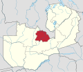 Copperbelt Province
 Eastern Province
 Luapula Province
 Lusaka Province
 North-Western Province
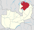 Northern Province
 Southern Province
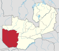 Western Province
 Muchinga Province


 Central Zambia districts
 Copperbelt districts
 Eastern Zambia districts
 Luapula districts
 Lusaka districts
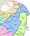 Muchinga Zambia districts
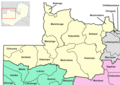 North-Western Zambia districts
 Northern Zambia districts
 Southern Zambia districts
 Western Zambia districts


