Atlas of Algeria

From Wikimedia Commons, the free media repository
Jump to navigation Jump to search
Wikimedia Commons Atlas of the World

The Wikimedia Atlas of the World is an organized and commented collection of geographical, political and historical maps available at Wikimedia Commons.
Discussion • Update the atlas • Index of the Atlas • Atlas in categories • Other atlases on line
The introductions of the country, dependency and region entries are in the native languages and in English. The other introductions are in English.
 
Atlas-country
Algeria


الجزائر
Lz̦ayer
Dzayer
Algérie

العربية [1]الجزائر - الجمهورية الجزائرية الديمقراطية الشعبية

'الجمهورية الجزائرية الديمقراطية الشعبية هي دولة تقع في شمال القارة الأفريقية، يحدها شمالاً البحر الأبيض المتوسط، وغربا المملكة المغربية وفي الجنوب الغربي الصحراء الغربية، موريتانيا ومالي وفي الجنوب الشرقي النيجر وشرقا ليبيا و في الشمال الشرقي تونس وعاصمتها الجزائر تقع في أقصى الشمال ، العملة المتداولة هي الدينار الجزائري، وأكبر مدنها الجزائر، وهران و قسنطينة.

الجزائر هي عضو مؤسس في منظمة المغرب العربي سنة 1988، عضو في جامعة الدول العربية و منظمة الأمم المتحدة منذ استقلالها، عضو في منظمة الوحدة الأفريقية و العديد من المؤسسات العالمية و الأقليمية.

من حيث مساحتها الجزائر هي أكبر بلد أفريقي و عربي العاشر في العالم.تضم المنطقة الشمالية التي تمتد من سلسلة جبال الأطلس إلى البحر 94% من مجموع السكان.

أرض الجزائر عبارة عن صحراء واسعة، وثمة سهل ساحلي في الشمال على امتداد المتوسط، وجبال أهمها سلاسل أطلس التل، وهي بموازاة السهل الساحلي، وجبال أطلس الصحراء باتجاه الجنوب، وفيها أعلى قمة في الجزائر وهي قمة تاهات وارتفاعها 3,303 م، وثمة جبال القبائل والأوراس وأولاد نايل والزاب. ليس في البلاد أنهار دائمة الجريان، وإنما هي أودية تمتلىء بالمياه في الشتاء، ثم تنضب لتتحول إلى مراعٍ خصبة أو لتصير أحواضا مغلقة تعرف باسم الشطوط وأهمها شط الحضنة وملفيغ، وتتكوّن من صحار رملية (العرق) وحجرية (جمادة). والفوسفات والزيوت والتمور والفواكه والخ

Tamazight Lz̦ayer
Taqbaylit Dzayer, isem unṣib: Tagduda tamegdayt taɣerfant n dzayer, d tamurt tezga-d deg Tefriqt ugafa. Imezdaɣ-is ttmeslayen taɛrabt, tamaziɣt (taqbaylit, tacawit, Tumẓabt, tamaceq, heqbaylit) d trumit. Tutlayt tunṣibt ines d taɛrabt, ddin unṣib ines lislam.
Français Algérie - République algérienne démocratique et populaire

La République algérienne démocratique et populaire est un pays d’Afrique du Nord appartenant au Maghreb. Sa capitale Alger est située à l’extrême nord du pays. Deuxième pays d’Afrique par sa superficie, l’Algérie est bordée au nord par la mer Méditerranée, elle partage également des frontières terrestres avec la Tunisie au nord-est, la Libye à l’est, le Niger au sud-est, le Sahara occidental, la Mauritanie, le Mali au sud-ouest, et enfin le Maroc à l’ouest.

English Algeria - People's Democratic Republic of Algeria

The People's Democratic Republic of Algeria is the largest country on the African continent. It is bordered by ► Tunisia in the north east, ► Libya in the east, ► Niger in the southeast, ► Mali and ► Mauritania in the south west, and ► Morocco as well as a few kilometers of the ► Western Sahara, in the west. Constitutionally, it is defined as an Islamic, Arab, and Amazigh (Berber) country. The name Algeria is derived from the name of the city of Algiers (French Alger), from the Arabic word al-jazā’ir, which translates as the islands, referring to the four islands which lay off the city's coast until becoming part of the mainland in 1525.


Short name  Algeria
Official name People's Democratic Republic of Algeria
Status Independent country since 1962
Location North Africa
Capital [2] الجزائر (Algiers)
Lz̦ayer
Alger
Population 44,227,000 inhabitants
Area 2,381,741 square kilometres (919,595 sq mi)
Major languages Arabic and Berber (both official), French
Major religions Islam
More information Algeria, Geography of Algeria, History of Algeria and Politics of Algeria
More images Algeria - Algeria (Category).

In Arabic

General maps

موقع الجزائر
Location of Algeria

Localisation de l'Algérie
خريطة الجزائر
Map of Algeria
Carte de l'Algérie
خريطة الجزائر (بالعربي)
Map of Algeria (in Arabic)
Carte de l'Algérie (en arabe)
خريطة الجزائر (بالفرنسي)
Map of Algeria (in French)
Carte de l'Algérie
خريطة الجزائر الجغرافية
Geographical map of Algeria
Carte géographique de l'Algérie
خريطة الجزائر الجغرافية
same map in French
Même carte en français
ولايات الجزائر
Provinces of Algeria
Les Wilayas d'Algérie
Divisions in provinces (in Arabic)
Les Wilayas d'Algérie (en arabe)

History maps

This section holds a short summary of the history of the area of present-day Algeria, illustrated with maps, including historical maps of former countries and empires that included present-day Algeria.

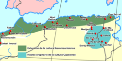
The Ibero-Mauritan culture (appr. 10.000 BCE) and the Capsian culture (10.000-6.000 BCE)
La culture ibéromaurusienne
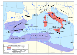
Location of Carthage and Carthaginian influence sphere before the First Punic War (264 BC)
Localisation de Carthage et la sphère d'influence carthagienne avant la Première Guerre punique
Territorial development of the Roman Empire 264 BC-192, including the conquest of present Algeria
Développement territoriale de l'Empire romain 264 AC-192
The Roman Republic and Carthago in 218, just prior to the Second Punic War
La fr:République Romain et Carthage, 218
Hannibals invasion in the Punic Wars
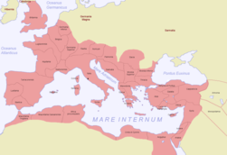
The extent of the Roman Republic and Roman Empire;
 
133 BC
 
44 BC (late Republic, after conquests by republican generals)
 
AD 14 (death of Augustus)
 
117 (maximum extension)
Map of the Roman Empire in 116
Roman Empire in 117
Africa romana end of IInd century
Roman Empire divided 395
The division of the Empire after the death of Theodosius I, ca.395 AD superimposed on modern borders.
Western Roman Empire 395
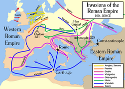
Invasions of the Roman Empire 100-500
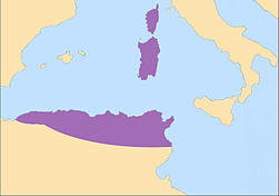
Kingdom of the Vandals and Alans in 455
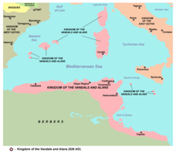
Kingdom of the Vandals and Alans in 526
Age of the Caliphs
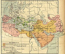
Caliphate around 750
Conquest by the Ottoman Empire
Growth of the Ottoman Empire
Location of the Ottoman Empire in 1683
Map of the Ottoman Empire 1801
Algeria as part of the French colonial empire (1830-1962)
Division in Departments 1974-1983
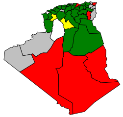
Algerian National Assembly elections, 1991
Algerian massacres 1997-1998

Old maps

This section holds copies of original general maps more than 70 years old.

Kabylie region
The french departement of Constantine 1848-1955

Ethno-linguistic maps

Tribes of Algeria
Berber language map
Various Berber languages
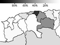
Distributions of Berbers in Algeria. Light purple : Chenwis; Red : Kabyles; Green : Chawis; Orange : Saharian Berbers (Zenagas, Mozabites, Siwis) and Dark Blue : Tuaregs
Berber linguistic map
French map of linguistic areas in North-Eastern Algeria
Kabyle linguistic map

Other maps

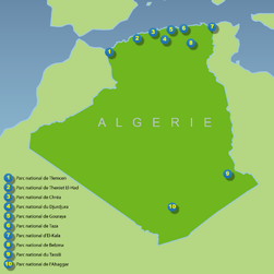
National Parks in Algeria
Military regions

Satellite maps

Satellite map
Satellite map

Notes and references

General remarks:

  • The WIKIMEDIA COMMONS Atlas of the World is an organized and commented collection of geographical, political and historical maps available at Wikimedia Commons. The main page is therefore the portal to maps and cartography on Wikimedia. That page contains links to entries by country, continent and by topic as well as general notes and references.
  • Every entry has an introduction section in English. If other languages are native and/or official in an entity, introductions in other languages are added in separate sections. The text of the introduction(s) is based on the content of the Wikipedia encyclopedia. For sources of the introduction see therefore the Wikipedia entries linked to. The same goes for the texts in the history sections.
  • Historical maps are included in the continent, country and dependency entries.
  • The status of various entities is disputed. See the content for the entities concerned.
  • The maps of former countries that are more or less continued by a present-day country or had a territory included in only one or two countries are included in the atlas of the present-day country. For example the Ottoman Empire can be found in the Atlas of Turkey.
  1. Romanization: al-Jazā’ir - Al-Jumhurīyah al-Jazā’irīyah ad-Dīmuqrāṭīyah ash-Sha’bīyah.
  2. Romanization: Al Jaz'ir.

Entries available in the atlas

General pages
Atlas   ■ Historical atlas   ■ Index of the Atlas   ■ Names in native languages

The world and its continents and oceans
Quick reference   ■ Historical maps of the world   ■ Old maps
Physical and topographical   ■ Political   ■ Geological   ■ People   ■ Time and time zones   ■ Projections of the globe
Africa   ■ North and South America   ■ Antarctica   ■ Asia   ■ Europe

(History, European Union)   ■ Oceania   ■ Oceans

Themes
Administrative divisions   ■ International organizations   ■ Languages   ■ Religions

Historical eras
Prehistory   ■ Antiquity   ■ Middle Ages   ■ Rise of Islam   ■ Early Modern Age   ■ Early American Societies   ■ Early Asian Societies   ■ Age of Renaissance   ■ Colonialism   ■ Stielers Handatlas 1891   ■ 20th Century   ■ World War I   ■ World War II

Entities with undisputed sovereign status
Afghanistan   ■ Albania   ■ Algeria   ■ Andorra   ■ Angola   ■ Antigua and Barbuda   ■ Argentina   ■ Armenia   ■ Australia   ■ Austria   ■ Azerbaijan   ■ Bahamas   ■ Bahrain   ■ Bangladesh   ■ Barbados   ■ Belarus   ■ Belgium   ■ Belize   ■ Benin   ■ Bhutan   ■ Bolivia   ■ Bosnia and Herzegovina   ■ Botswana   ■ Brazil   ■ Brunei   ■ Bulgaria   ■ Burkina Faso   ■ Burundi   ■ Cambodia   ■ Cameroon   ■ Canada   ■ Cape Verde   ■ Central African Republic   ■ Chad   ■ Chile   ■ China   ■ Colombia   ■ Comoros   ■ Congo (Democratic Republic)   ■ Congo (Republic)   ■ Costa Rica   ■ Côte d’Ivoire   ■ Croatia   ■ Cuba   ■ Cyprus   ■ Czech Republic   ■ Denmark   ■ Djibouti   ■ Dominica   ■ Dominican Republic   ■ East Timor   ■ Ecuador   ■ Egypt   ■ El Salvador   ■ Equatorial Guinea   ■ Eritrea   ■ Estonia   ■ Eswatini   ■ Ethiopia   ■ Fiji   ■ Finland   ■ France   ■ Gabon   ■ Gambia   ■ Georgia   ■ Germany   ■ Ghana   ■ Greece   ■ Grenada   ■ Guatemala   ■ Guinea   ■ Guinea-Bissau   ■ Guyana   ■ Haiti   ■ Honduras   ■ Hungary   ■ Iceland   ■ India   ■ Indonesia   ■ Iran   ■ Iraq   ■ Ireland   ■ Israel   ■ Italy   ■ Jamaica   ■ Japan   ■ Jordan   ■ Kazakhstan   ■ Kenya   ■ Kiribati   ■ Korea (Democratic People’s Republic)   ■ Korea (Republic)   ■ Kuwait   ■ Kyrgyzstan   ■ Laos   ■ Latvia   ■ Lebanon   ■ Lesotho   ■ Liberia   ■ Libya   ■ Liechtenstein   ■ Lithuania   ■ Luxembourg   ■ Madagascar   ■ Malawi   ■ Malaysia   ■ Maldives   ■ Mali   ■ Malta   ■ Marshall Islands   ■ Mauritania   ■ Mauritius   ■ Mexico   ■ Micronesia (Federated States)   ■ Moldova   ■ Monaco   ■ Mongolia   ■ Montenegro   ■ Morocco   ■ Mozambique   ■ Myanmar   ■ Namibia   ■ Nauru   ■ Nepal   ■ Netherlands   ■ New Zealand   ■ Nicaragua   ■ Niger   ■ Nigeria   ■ North Macedonia   ■ Norway   ■ Oman   ■ Pakistan   ■ Palau   ■ Panama   ■ Papua New Guinea   ■ Paraguay   ■ Peru   ■ Philippines   ■ Poland   ■ Portugal   ■ Qatar   ■ Romania   ■ Russia   ■ Rwanda   ■ Saint Kitts and Nevis   ■ Saint Lucia   ■ Saint Vincent and the Grenadines   ■ Samoa   ■ San Marino   ■ São Tomé and Príncipe   ■ Saudi Arabia   ■ Senegal   ■ Serbia   ■ Seychelles   ■ Sierra Leone   ■ Singapore   ■ Slovakia   ■ Slovenia   ■ Solomon Islands   ■ Somalia   ■ South Africa   ■ South Sudan   ■ Spain   ■ Sri Lanka   ■ Sudan   ■ Suriname   ■ Sweden   ■ Switzerland   ■ Syria   ■ Tajikistan   ■ Tanzania   ■ Thailand   ■ Togo   ■ Tonga   ■ Trinidad and Tobago   ■ Tunisia   ■ Turkey   ■ Turkmenistan   ■ Tuvalu   ■ Uganda   ■ Ukraine   ■ United Arab Emirates   ■ United Kingdom   ■ United States   ■ Uruguay   ■ Uzbekistan   ■ Vanuatu   ■ Vatican City   ■ Venezuela   ■ Vietnam   ■ Yemen   ■ Zambia   ■ Zimbabwe

Entities with disputed sovereign status
Abkhazia   ■ Artsakh   ■ Kosovo   ■ Northern Cyprus   ■ Palestine   ■ Somaliland   ■ South Ossetia   ■ Taiwan   ■ Tatarstan   ■ Transnistria   ■ Western Sahara

Dependencies and other overseas territories
Akrotiri and Dhekelia   ■ Åland   ■ American Samoa   ■ Anguilla   ■ Aruba   ■ Ascension Island   ■ Ashmore and Cartier Islands   ■ Baker Island   ■ Bermuda   ■ Bouvet Island   ■ British Indian Ocean Territory   ■ British Virgin Islands   ■ Cayman Islands   ■ Christmas Island   ■ Clipperton Island   ■ Cocos (Keeling) Islands   ■ Cook Islands   ■ Coral Sea Islands   ■ Curaçao   ■ Faroe Islands   ■ French Guiana   ■ French Polynesia   ■ French Southern and Antarctic Lands   ■ Gibraltar   ■ Greenland   ■ Guadeloupe   ■ Guam   ■ Guantanamo Bay   ■ Guernsey   ■ Heard Island and McDonald Islands   ■ Hong Kong   ■ Howland Island   ■ Isle of Man   ■ Jan Mayen   ■ Jarvis Island   ■ Jersey   ■ Johnston Atoll   ■ Kingman Reef   ■ Macau   ■ Martinique   ■ Mayotte   ■ Midway Atoll   ■ Montserrat   ■ Navassa Island   ■ New Caledonia   ■ Niue   ■ Norfolk Island   ■ Northern Mariana Islands   ■ Palmyra Atoll   ■ Pitcairn Islands   ■ Puerto Rico   ■ Réunion   ■ Saint Helena   ■ Saint Martin (France)   ■ Saint-Barthélemy   ■ Saint-Pierre and Miquelon   ■ Sint Maarten (Netherlands)   ■ Svalbard   ■ Tokelau   ■ Tristan da Cunha   ■ Turks and Caicos Islands   ■ United States Virgin Islands   ■ Wake Island   ■ Wallis and Futuna

Disputed subnational entities and territories
Bajo Nuevo Bank   ■ Crimea   ■ Falkland Islands   ■ Gilgit–Baltistan   ■ Kurdistan (Syrian)   ■ Kashmir   ■ Ladakh   ■ Paracel Islands   ■ Serranilla Bank   ■ South Georgia and South Sandwich Islands   ■ Spratly Islands   ■

Subnational autonomous entities
Aceh   ■ Adjara   ■ Adygea   ■ Altai   ■ Andalusia   ■ Aosta Valley   ■ Aragon   ■ Asturias   ■ Athos   ■ Azores   ■ Balearic Islands   ■ Bashkortostan   ■ Basque Autonomous Community   ■ Bonaire   ■ Bosnia and Herzegovina (Federation of)   ■ Bougainville   ■ Brussels   ■ Buryatia   ■ Canary Islands   ■ Catalonia   ■ Chechnya   ■ Chuvashia   ■ Corsica   ■ Dagestan   ■ Easter Island   ■ England   ■ Extremadura   ■ Flanders   ■ Friuli-Venezia Giulia   ■ Gagauzia   ■ Galicia   ■ Galápagos Islands   ■ Gilgit–Baltistan   ■ Gorno-Badakhshan   ■ Guangxi   ■ Ingushetia   ■ Islamabad Capital Territory   ■ Inner Mongolia   ■ Kabardino-Balkaria   ■ Kalmykia   ■ Karachay-Cherkessia   ■ Karakalpakstan   ■ Karelia   ■ Khakassia   ■ Komi   ■ Kurdistan (Iraqi)   ■ Khyber Pakhtunkhwa   ■ Madeira   ■ Mari El   ■ Muslim Mindanao   ■ Mordovia   ■ Nakhichevan   ■ Navarre   ■ Nevis   ■ Ningxia   ■ North Ossetia – Alania   ■ Northern Ireland   ■ Nunatsiavut   ■ Quebec   ■ Saba   ■ Sakha   ■ Sardinia   ■ Scotland   ■ Sicily   ■ Sindh   ■ Sint Eustatius   ■ Srpska   ■ Tibet   ■ Tłı̨chǫ   ■ Trentino-Alto Adige   ■ Tuva   ■ Udmurtia   ■ Vojvodina   ■ Wales   ■ Wallonia   ■ Xinjiang   ■ Zanzibar

Other regions
Basque Country   ■ Burzenland   ■ Catalan Countries   ■ Frisia   ■ Kurdistan   ■ Manchuria   ■ Sápmi   ■ Svenskfinland   ■ Székely Land   ■ Transylvania

Former sovereign nations
Austria-Hungary   ■ Byzantine Empire   ■ Caliphate   ■ Czechoslovakia   ■ Frankish Empire   ■ Kingdom of Hawaiʻi   ■ Inca Empire   ■ Iroquois Confederacy   ■ Macedonian Empire   ■ Ottoman Empire   ■ Prussia   ■ Roman Empire   ■ Soviet Union   ■ Republic of Texas   ■ Vermont Republic   ■ Republic of West Florida   ■ Yugoslavia

Former dependencies and overseas territories
Netherlands Antilles

Former disputed territories
Tamil Eelam


References