La République centrafricaine, souvent appelée Centrafrique, est un pays situé en Afrique. Les pays frontaliers sont le Cameroun à l'ouest, le Tchad au nord, le Soudan à l'est, la République démocratique du Congo (ex-Zaïre) et la République du Congo au sud.
The Central African Republic is a landlocked country in central Africa. It borders ► Chad in the north, ► Sudan on the east, the ► Republic of the Congo and the ► Democratic Republic of the Congo on the south, and ► Cameroon on the west. Most of the CAR consists of Sudano-Guinean savannas but it also includes a Sahelo-Sudanese zone in the north and an Equatorial forest zone in the south. Two thirds of the country lies in the basins of the Ubangi river, which flows south into the Congo River, while the remaining third lies in the basin of the Shari river, which flows north into Lake Chad.
Short name
Central African Republic
Official name
Central African Republic
Status
Independent country since 1960
Location
Central Africa
Capital
Bangî Bangui
Population
3,895,139 inhabitants
Area
622,948 square kilometres (240,522 sq mi)
Major languages
French and Sango (both official)
Major religions
Indigenous beliefs, Protestantism, Roman Catholicism, Islam
This section holds a short summary of the history of the area of present-day the Central African Republic, illustrated with maps, including historical maps of former countries and empires that included present-day the Central African Republic.
Since the nineteenth century the area of the present-day Central African Republic is inhabited by Sudanese tribes, the Banda and the Baya. Before that the are appears to have been settled from at least the 7th century on by overlapping empires, including the Kanem-Bornu, Ouaddai, Baguirmi and Dafour groups based in Lake Chad and the Upper Nile. Later, various sultanates claim the region as a slave reservoir, from which slaves were traded north across the Sahara and to West Africa for export by the Europeans. In 1875 the Egyptian sultan Rabah governs Upper-Oubangui. Europeans, primarily the French, German and Belgians arrive in the area in 1885.
The French gets possession of the right bank of the Oubangui River in 1887 and form the territory of Upper-Ubangui, that becomes part of French Congo. Two years later, the French established an outpost at Bangui, and in 1894 Oubangui-Chari became a French territory. France consolidates its control over the territory in 1903 after having defeated the forces of Rabah and establishes colonial administration throughout the territory.
In 1907 France establishes the separate colony of Ubangui-Chari-Chad, this colony becomes in 1910 a constituent part of French Equatorial Africa. The territory is divided in 1920 into Ubangui-Chari and Chad. Ubangui-Chari becomes a French overseas territory in 1946 and when in 1958 French Equatorial Africa is dissolved, it gets autonomy as the Central African Republic.
In 1960 the Central African Republic becomes an independent republic. Between 1972 and 1976 the country is names Central African Empire.
Old maps
This section holds copies of original general maps more than 70 years old.
Oubangui-Chari in 1910. Note the borders are reduced to the southeastern section of the present-day CAR
Ethnic maps
Maka-Njem Ethnic groups
Satellite maps
Satellite map
Notes and references
General remarks:
The WIKIMEDIA COMMONS Atlas of the World is an organized and commented collection of geographical, political and historical maps available at Wikimedia Commons. The main page is therefore the portal to maps and cartography on Wikimedia. That page contains links to entries by country, continent and by topic as well as general notes and references.
Every entry has an introduction section in English. If other languages are native and/or official in an entity, introductions in other languages are added in separate sections. The text of the introduction(s) is based on the content of the Wikipedia encyclopedia. For sources of the introduction see therefore the Wikipedia entries linked to. The same goes for the texts in the history sections.
Historical maps are included in the continent, country and dependency entries.
The status of various entities is disputed. See the content for the entities concerned.
The maps of former countries that are more or less continued by a present-day country or had a territory included in only one or two countries are included in the atlas of the present-day country. For example the Ottoman Empire can be found in the Atlas of Turkey.


 Bamingui-Bangoran Prefecture
 Bangui Autonomous Commune
 Basse-Kotto Prefecture
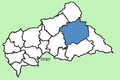 Haute-Kotto Prefecture
 Haut-Mbomou Prefecture
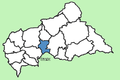 Kémo Prefecture
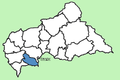 Lobaye Prefecture
 Mambéré-Kadéï Prefecture
 Mbomou Prefecture
 Nana-Grébizi Prefecture
 Nana-Mambéré Prefecture
 Ombella-M'Poko Prefecture
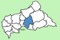 Ouaka Prefecture
 Ouham Prefecture
 Ouham-Pendé Prefecture
 Sangha-Mbaéré Prefecture
 Vakaga Prefecture


