La République du Niger est un pays d'Afrique de l'ouest, situé entre l'Algérie, le Bénin, le Burkina Faso, le Tchad, la Libye, le Mali et le Nigeria. La capitale est Niamey. Les habitants sont des nigériens (ceux du Nigeria sont des nigérians). Parmi les ressources naturelles du Niger, on pourrait citer l'or, le fer, le charbon, l'uranium et le pétrole. Certains animaux, comme les éléphants, les lions et les girafes, sont en danger de disparition en raison de la destruction de la forêt et du braconnage.
The Republic of Niger is a landlocked sub-Saharan country in Western Africa, named after the Niger River. It borders ► Nigeria and ► Benin to the south, ► Burkina Faso and ► Mali to the west, ► Algeria and ► Libya to the north and ► Chad to the east. The capital city is Niamey.
Short name
Niger
Official name
Republic of Niger
Status
Independent country since 1960
Location
West Africa
Capital
Niamey
Population
23,196,002 inhabitants
Area
1,267,000 square kilometres (489,000 sq mi)
Major languages
French (official), Hausa, Djerma, Tamasheq, Fulfulde, Kanuri, Arabic, Teda
This section holds a short summary of the history of the area of present-day Niger, illustrated with maps, including historical maps of former countries and empires that included present-day Niger.
Long before the arrival of French influence and control in the area, present-day Niger is an important economic crossroads, and the empires of Songhai, Mali, Gao and Kanem-Bornu as well as a number of Hausa states claim control over portions of the area.
During recent centuries, the nomadic Tuareg form large confederations, push southward and - siding with various Hausa states - clash with the Fulani Empire of Sokoto, which had gained control of much of the Hausa territory in the late 18th century.
In the 1880s it is penetrated by France, that annexes it in 1900 and makes this military territory part of French West Africa. Niger becomes a separate colony in 1921. In addition to conferring French citizenship on the inhabitants of the territory, the 1946 French constitution provides for decentralization of power and limited participation in political life for local advisory assemblies.
1958-1960: Republic of Niger (République du Niger) - autonomous republic
After the dissolution of French West Africa in 1958, Niger gets autonomy as the Republic of Niger.
Independence
1960-present: Republic of Niger (République du Niger) - independent republic
In 1960 Niger becomes an independent republic.
Ethnic and linguistic maps
Areas in Niger where Hausa language is spoken. Note: Speakers of Hausa are mixed with speakers of other languages and thus this map does not necessarily represent areas with Hausa speaking majority.
Areas in Niger where Hausa language is spoken. Note: Speakers of Hausa are mixed with speakers of other languages and thus this map does not necessarily represent areas with Hausa speaking majority.
Satellite maps
Satellite map
Notes and references
General remarks:
The WIKIMEDIA COMMONS Atlas of the World is an organized and commented collection of geographical, political and historical maps available at Wikimedia Commons. The main page is therefore the portal to maps and cartography on Wikimedia. That page contains links to entries by country, continent and by topic as well as general notes and references.
Every entry has an introduction section in English. If other languages are native and/or official in an entity, introductions in other languages are added in separate sections. The text of the introduction(s) is based on the content of the Wikipedia encyclopedia. For sources of the introduction see therefore the Wikipedia entries linked to. The same goes for the texts in the history sections.
Historical maps are included in the continent, country and dependency entries.
The status of various entities is disputed. See the content for the entities concerned.
The maps of former countries that are more or less continued by a present-day country or had a territory included in only one or two countries are included in the atlas of the present-day country. For example the Ottoman Empire can be found in the Atlas of Turkey.


 Agadez arrondissements
 Diffa arrondissements
 Dosso arrondissements
 Maradi arrondissements
 Niamey district
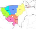 Tillaberi arrondissements


