La République gabonaise est un pays à l'ouest de l'Afrique centrale très peu peuplé. Situé entre le Congo, la Guinée équatoriale et le Cameroun, c’est un pays forestier où la faune et la flore sont encore bien conservées. Anciennement impliqué dans le commerce triangulaire, puis colonie française, le Gabon est indépendant depuis 1960.
The Gabonese Republic is a country in west central Africa. It borders on ► Equatorial Guinea, ► Cameroon, ► Republic of the Congo and the Gulf of Guinea with ► São Tomé and Príncipe. A small population, abundant natural resources, and foreign private investment have helped make Gabon one of the most prosperous countries in the region.
This section holds a short summary of the history of the area of present-day Gabon, illustrated with maps, including historical maps of former countries and empires that included present-day Gabon.
The WIKIMEDIA COMMONS Atlas of the World is an organized and commented collection of geographical, political and historical maps available at Wikimedia Commons. The main page is therefore the portal to maps and cartography on Wikimedia. That page contains links to entries by country, continent and by topic as well as general notes and references.
Every entry has an introduction section in English. If other languages are native and/or official in an entity, introductions in other languages are added in separate sections. The text of the introduction(s) is based on the content of the Wikipedia encyclopedia. For sources of the introduction see therefore the Wikipedia entries linked to. The same goes for the texts in the history sections.
Historical maps are included in the continent, country and dependency entries.
The status of various entities is disputed. See the content for the entities concerned.
The maps of former countries that are more or less continued by a present-day country or had a territory included in only one or two countries are included in the atlas of the present-day country. For example the Ottoman Empire can be found in the Atlas of Turkey.


.jpg)
 Départements d'Estuaire
 Départements de Haut-Ogooué
 Départements de Moyen-Ogooué
 Départements de Ngounié
 Départements de Nyanga
 Départements d'Ogooué-Ivindo
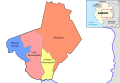 Départements d'Ogooué-Lolo
 Départements d'Ogooué-Maritime
 Départements de Woleu-Ntem


