La República de Guatemala, del náhuatl: Coactimaltlan: "Territorio muy arbolado", o "País de muchos bosques" , es un país de América Central, el más septentrional del istmo. Limita al norte y occidente con México, al nororiente con Belice y el Mar Caribe, al sur con el Océano Pacífico y al suroriente con Honduras y El Salvador. Su geografía física es en gran parte montañosa. Posee playas en el litoral del Pacífico y planicies bajas al norte del país. Es atravesado en su parte central por la Sierra Madre Chiapas.
The Republic of Guatemala is a country in Central America, in the south part of North America, bordering ► Mexico to the northwest, the Pacific Ocean to the southwest, ► Belize and the Caribbean Sea to the northeast, and ► Honduras and ► El Salvador to the southeast.
Short name
Guatemala
Official name
Republic of Guatemala
Status
Independent country since 1821
Location
Central America
Capital
Ciudad de Guatemala (Guatemala City)
Population
16,858,333 inhabitants
Area
108,890 square kilometres (42,040 sq mi)
Major languages
Spanish (official), Mayan languages
Major religions
Roman Catholicism, Protestantism, and Indigenous Mayan Beliefs
This section holds a short summary of the history of the area of present-day Guatemala, illustrated with maps, including historical maps of former countries and empires that included present-day Guatemala.
The WIKIMEDIA COMMONS Atlas of the World is an organized and commented collection of geographical, political and historical maps available at Wikimedia Commons. The main page is therefore the portal to maps and cartography on Wikimedia. That page contains links to entries by country, continent and by topic as well as general notes and references.
Every entry has an introduction section in English. If other languages are native and/or official in an entity, introductions in other languages are added in separate sections. The text of the introduction(s) is based on the content of the Wikipedia encyclopedia. For sources of the introduction see therefore the Wikipedia entries linked to. The same goes for the texts in the history sections.
Historical maps are included in the continent, country and dependency entries.
The status of various entities is disputed. See the content for the entities concerned.
The maps of former countries that are more or less continued by a present-day country or had a territory included in only one or two countries are included in the atlas of the present-day country. For example the Ottoman Empire can be found in the Atlas of Turkey.


 Departamento de
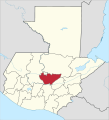 Departamento de Baja Verapaz
 Departamento de Chimaltenango
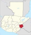 Departamento de Chiquimula
 Departamento de El Progreso
 Departamento de Escuintla
 Departamento de Guatemala
 Departamento de Huehuetenago
 Departamento de Izabal
 Departamento de Jalapa
 Departamento de Jutiapa
 Departamento de Petén
 Departamento de Quetzaltenango
 Departamento de Quiché
 Departamento de Retalhuleu
 Departamento de Sacatepéquez
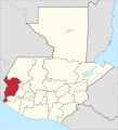 Departamento de San Marcos
 Departamento de Santa Rosa
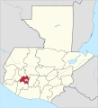 Departamento de Sololá
 Departamento de Suchitepequez
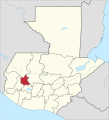 Departamento de Totonicapán
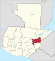 Departamento de Zacapa


