Atlas of Chile
Other territories: Aruba · Bonaire · Curaçao · Falkland Islands · French Guiana · South Georgia and the South Sandwich Islands
‡: partly located in South America

|
Wikimedia Commons Atlas of the World The Wikimedia Atlas of the World is an organized and commented collection of geographical, political and historical maps available at Wikimedia Commons. Discussion • Update the atlas • Index of the Atlas • Atlas in categories • Other atlases on line |
|
| ||||||||||||||||||||||||||||||||||||||||


General maps
 |
 |
 |
 |
Mapas del Ministerio de Obras Públicas
Los mapas no son libres en el sentido de commons, pero pueden ser vistos en el sitio web del ministerio bajo:
- Planes Regionales de Infraestructura y Gestión del Recurso Hídrico al 2021 archive copy at the Wayback Machine
(bajo el enlace "Descargar mapa cartera de proyectos")
Estan basados en datos de la NASA, SRTM, y muestran caminos, poblados, ríos, etc en muy buena resolución.
Mapas topográficos
 |
 |
 |
Shuttle Radar Topography Mission
 |
CastellanoLos mapas a que puedes acceder con un click sobre el mapa a la izquierda fueron generados con Generic Maping Tools (http://gmt.soest.hawaii.edu/archive copy at the Wayback Machine) y utilizan los registros topográficos de la Shuttle Radar Topography Mission (SRTM) (ftp://e0srp01u.ecs.nasa.gov/srtm/version2/SRTM3/[dead link]) que registran los cambios cada 3 segundos de grado, es decir cada 90 metros. La toponimia fue obtenida de http://earth-info.nga.mil/gns/html/cntry_files.html archive copy at the Wayback Machine y no es muy exacta. Clica sobre la imagen para abrir una imagen más detallada de cada zona. DeutschClick auf die gewünschte Region auf der (linke) Chile-Karte um die topographische Karte zu bekommen. Die Landkarten sind mit Generic Maping Tools (http://gmt.soest.hawaii.edu/archive copy at the Wayback Machine) erstellt worden und sie verwenden die topographischen Daten aus Shuttle Radar Topography Mission (SRTM) (ftp://e0srp01u.ecs.nasa.gov/srtm/version2/SRTM3/[dead link]) die die Höhen jede 3 Sekunden gemessen haben, d.h. jede 90 m. Die Ortsnamen wurden aus http://earth-info.nga.mil/gns/html/cntry_files.html archive copy at the Wayback Machine geholt und sie sind nicht sehr exakt. EnglishClick on the map at the left side to obtain topographic Maps generated with Generic Maping Tools (http://gmt.soest.hawaii.edu/archive copy at the Wayback Machine) and the topographic data from Shuttle Radar Topography Mission (SRTM) (ftp://e0srp01u.ecs.nasa.gov/srtm/version2/SRTM3/[dead link]) (90 m resolution). The toponymy is from http://earth-info.nga.mil/gns/html/cntry_files.html archive copy at the Wayback Machine, but it is not exact. עבריתאת המפות ניתן לגשת באמצעות לחץ על המפה שמאלה היו שנוצר עם Generic MapingTools(http://gmt.soest.hawaii.edu/archive copy at the Wayback Machine) ולהשתמש רשומות של theShuttle טופוגרפיות רדאר טופוגרפיהמיסיון (SRTM) (ftp://e0srp01u.ecs.nasa.gov/srtm/version2/SRTM3/[dead link]) כי שינויים שיא כל תואר של 3 שניות, כלומר כל 90 מטרים. שמות מקום נתקבלו http://earth-info.nga.mil/gns/html/cntry_files.html archive copy at the Wayback Machine ולא מאוד מדויק. לחץ על התמונה כדי לפתוח תמונה מפורטת יותר של כל אזור. |
| Ejemplo/Beispiel/Example (Ancho/Breite/Wide es/ist/is variable) | |
  | |
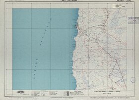
Joint Operations Graphics
Category:Joint Operations Graphic Chile
 |
CastellanoLas Joint Operations Graphics son excelentes mapas en escala 1:250.000 editados por las fuerzas armadas de USA. Los mapas muestran relieve topográfico, vegetación, caminos, vías férreas, líneas de trasmisión de energía eléctrica, ciudades, pueblos, aldeas, líneas de telegráfo, divisiones administrativas, aeródromos, etc. Sin embargo, solo algunas regiones han sido publicadas. En la imagen, para casi todos los cuadrados amarillos se puede obtener un mapa con un click. EnglishThe Joint Operations Graphics are outstanding maps of some regions of Chile edited by the USA-Government. They show topography, vegetation, roads, railroads, power transmision lines, cities, telegraph lines, county borders, aerodrome, etc. For most of the yellow areas are maps available. You can access the map in scale 1:250.000 clicking the area. DeutschDie Joint Operations Graphics sind herausragende Karten in Maßstab 1:250.000 die von der US-Streitkräfte veröffentlicht worden sind. Sie zeigen die Topographie, Vegetation, Landstraßen, Eisenbahnlinien, Hochspannungsleitungen, Städte, Dörfer, Telegraph-Linien, Verwaltungsgrenzen, usw. Leider sind nur wenige Regionen veröffentlicht worden. Für die meisten der gelben Rechtecken sind Karten mit einem Klick zu bekommen. Ejemplo, Example, BeispielZona de Arauco y la Cordillera de Nahuelbuta:  |
Mapas hidrográficos
Mapas de las cuencas hidrográficas de Chile pueden ser encontrados en Category:Maps of rivers of Chile (drainage basins BCN). Por ejemplo el mapa de la cuenca del es:Río Baker es el

Mapas de Enrique Espinoza
Es una serie de mapas publicados en 1903 que abarca desde Tacna hasta el Cabo de Hornos. Aunque no son muy detallados pueden ser usados para ubicar las ciudades, ríos y cerros mas importantes. Contiene ademas planos de Santiago, Valparaíso y planos de ramales ferroviarios, por ejemplo a Mendoza, Argentina.
Ver en Category:Maps of Chile by Enrique Espinoza
 |
 |
 |
Mapas de Chile publicados en Guía Chile de Carlos Tornero 1903
Ver en Category:Mapas de Chile publicados en Guia Chile de Carlos Tornero 1903
Son seis mapas con bastante información, por ejemplo:

Mapas del Sur de Chile
  |
  |
 |
 |
Mapas de Pissis
en:Pedro José Amadeo Pissis produjo a mediados del siglo XIX un serie de mapas del territorio chileno. Los puedes encontrar en Category:Chile by Pissis

Mapas y dibujos de Claudio Gay
Una fuente inagotable de belleza e información se encuentra en la carpeta Category:Atlas de la historia física y política de Chile, que contiene imágenes creadas en 1854 por encargo del gobierno de Chile.
Por ejemplo la provincia de Cauquenes:
.jpg)
.jpg)
Mapas de Luis Risopatrón
Excelentes mapas publicados en 1910-1911 elaborados por Nicanor Boloña y Dañino, Luis Ossandón y Cressy, Luis Risopatrón. Contienen ríos, ciudades, pueblos, cadenas de montañas, líneas de ferrocarril y caminos. Algunas zonas al sur están marcadas como inexploradas. Los mapas se encuentran en:
Ejemplo:
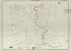
Mapas del Instituto Geográfico Militar de Chile, 1:250.000, década 1950
La colección es fabulosa, pero no están liberados todos los mapas. Ver Category:IGM-Chile. Ejemplo:
 |
 |
Mapas del Instituto Geográfico Militar 1:500.000
Publicados el año 1945 con escala de 1:500.000, todas la regiones excepto la Antártica. Ejemplo:
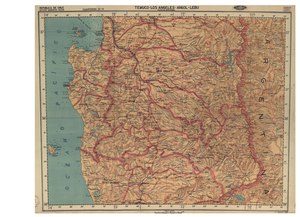
Pueden ser vistos (y utilizados) en:
Mapas étnicos

Mapas administrativos
.svg) |
 |
 |
 |
| En la categoría Category:SVG maps of Chile" encuentras, entre otros, mapas en formato SVG de cada comuna de Chile, por ejemplo, de la popular comuna de Conchalí de la ciudad de Santiago:
Under Category:SVG maps of Chile you may find, among others, SVG-maps of every 'comuna' in Chile, like e.g. the popular comune of Conchali in the city of Santiago:  |
 |
 |
Historia de Chile
 |
 |
 | |
 |
 |
  |
In 1810 Chile declares itself independent, but Spain recaptures Chile in 1814. In 1818 Chile finally gains independence in 1818 as the State of Chile, renamed Republic of Chile in 1826. |
Old maps
This section holds copies of original general maps more than 70 years old.

|
The War of the Pacific, sometimes called the Saltpeter War in reference to its original cause, was fought between Chile and the joint forces of Bolivia and Peru, from 1879 to 1884. Chile gained substantial mineral-rich territory in the conflict, annexing both the Peruvian province of Tarapacá and the Bolivian province of Litoral, leaving Bolivia as a landlocked country. |

|

|
Chile in 1597 by Van Wytflyet, Leuven |
.jpg)
|
Chile in 1635 by Jan Jansson, Amsterdam |

|
Chile and the coast of South America, 1659 |

|
Chile in 1669 by Nicolas Sanson |
.jpg)
|
The region in 1775 by D. Juan de la Cruz Cano y Olmedilla |
Other maps

|
Vegetation map |

|
Major volcanoes in Chile |

|
Density |
Satellite maps

|
Satellite map |
Notes and references
|
General remarks:
|