Japan is an island country comprising a stratovolcanic archipelago over 3,000 km (1,900 mi) long in East Asia. Located in the Pacific Ocean, it lies to the east of ► China, ► North Korea, ► South Korea and ► Russia, stretching from the Sea of Okhotsk in the north to the East China Sea and the Philippine Sea in the south. To the south lie ► Taiwan and the ► Philippines and to the east the ► Northern Mariana Islands, all three share maritime borders with Japan. The characters that make up Japan's name literally mean "sun-origin," thus Japan is identified as the "Land of the Rising Sun," derived from the country's eastward position relative to the Asian continent.
English: Hokkaido Pref. an edited version due to dispute area
עברית : מחוז הוקאידו ללא אזור מחלוקת (האיים הקוריליים)
青森県
English: Aomori Pref.
עברית : מחוז אאומורי
岩手県
English: Iwate Pref.
עברית : מחוז איווטה
宮城県
English: Miyagi Pref.
עברית : מחוז מיאגי
秋田県
English: Akita Pref.
עברית : מחוז אקיטה
山形県
English: Yamagata Pref.
עברית : מחוז יאמאגטה
福島県
English: Fukushima Pref.
עברית : מחוז פוקושימה
茨城県
English: Ibaraki Pref.
עברית : מחוז איבראקי
栃木県
English: Tochigi Pref.
עברית : מחוז טוג'יצי
群馬県
English: Gumma Pref.
עברית : מחוז גונמה
埼玉県
English: Saitama Pref.
עברית : מחוז סאיטאמה
千葉県
English: Chiba Pref.
עברית : מחוז צ'יבה
東京都
English: Tokyo Pref.
עברית : מחוז טוקיו
神奈川県
English: Kanagawa Pref.
עברית : מחוז קאנאגווה
新潟県
English: Niigata Pref.
עברית : מחוז ניאיגטה
富山県
English: Toyama Pref.
עברית : מחוז טויאמה
石川県
English: Ishikawa Pref.
עברית : מחוז אישיקווה
福井県
English: Fukui Pref.
עברית : מחוז פוקוי
山梨県
English: Yamanashi Pref.
עברית : מחוז יאמאנאשי
長野県
English: Nagano Pref.
עברית : מחוז נאגנו
岐阜県
English: Gifu Pref.
עברית : מחוז גיפו
静岡県
English: Shizuoka Pref.
עברית : מחוז שיזוקה
愛知県
English: Aichi Pref.
עברית : מחוז אייצ'י
三重県
English: Mie Pref.
עברית : מחוז מיה
滋賀県
English: Shiga Pref.
עברית : מחוז שיגה
京都府
English: Kyoto Pref.
עברית : מחוז קיוטו
大阪府
English: Osaka Pref.
עברית : מחוז אוסקה
兵庫県
English: Hyogo Pref.
עברית : מחוז היוגו
奈良県
English: Nara Pref.
עברית : מחוז נארה
和歌山県
English: Wakayama Pref.
עברית : מחוז וואקאימה
鳥取県
English: Tottori Pref.
עברית : מחוז טוטורי
島根県
English: Shimane Pref.
עברית : מחוז שימאנה
岡山県
English: Okayama Pref.
עברית : מחוז אוקאימה
広島県
English: Hiroshima Pref.
עברית : מחוז הירושימה
山口県
English: Yamaguchi Pref.
עברית : מחוז יאמגוצ'י
愛媛県
English: Ehime Pref.
עברית : מחוז אהימה
福岡県
English: Fukuoka Pref.
עברית : מחוז פוקוקה
長崎県
English: Nagasaki Pref.
עברית : מחוז נגסקי
熊本県
English: Kumamoto Pref.
עברית : מחוז קומאמוטו
大分県
English: Oita Pref.
עברית : מחוז אויטה
宮崎県
English: Miyazaki Pref.
עברית : מחוז מיאזאקי
鹿児島県
English: Kagoshima Pref.
עברית : מחוז קגושימה
沖縄県
English: Okinawa Pref.
עברית : מחוז אוקינאווה
History maps
This section holds a short summary of the history of the area of present-day Japan, illustrated with maps, including historical maps of former countries and empires that included present-day Japan.
Map of Ancient Japanese Provinces
Gokishichido Map (Five provinces and seven circuits)
Japan in 1183, Genpei War
Japan in 1570, Sengoku Jidai
Japan in late 16th century, Azuchi–Momoyama period
Emmanuel Bowen: A New & Accurate Map of The Empire of Japan (1744)
Kai Ichiran Zu map of Japan in 1806
Japan and Korea in 1815
Japan in 1821
Japan in 1855
Japan in 1900
Japan in 1911
Empire of Japan detailed topographic map, 1918
Satellite maps
Satellite map (2003)
Satellite map (1999)
Japanese archipelago with outlined islands (2004)
A relief map of the land and the seabed of Japan (2009)
Extreme points of Japan (2009)
Notes and references
General remarks:
The WIKIMEDIA COMMONS Atlas of the World is an organized and commented collection of geographical, political and historical maps available at Wikimedia Commons. The main page is therefore the portal to maps and cartography on Wikimedia. That page contains links to entries by country, continent and by topic as well as general notes and references.
Every entry has an introduction section in English. If other languages are native and/or official in an entity, introductions in other languages are added in separate sections. The text of the introduction(s) is based on the content of the Wikipedia encyclopedia. For sources of the introduction see therefore the Wikipedia entries linked to. The same goes for the texts in the history sections.
Historical maps are included in the continent, country and dependency entries.
The status of various entities is disputed. See the content for the entities concerned.
The maps of former countries that are more or less continued by a present-day country or had a territory included in only one or two countries are included in the atlas of the present-day country. For example the Ottoman Empire can be found in the Atlas of Turkey.


 北海道English: Hokkaido Prefעברית : מחוז הוקאידו
 北海道English: Hokkaido Pref.
 青森県English: Aomori Pref.עברית : מחוז אאומורי
 岩手県English: Iwate Pref.עברית : מחוז איווטה
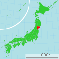 宮城県English: Miyagi Pref.עברית : מחוז מיאגי
 秋田県English: Akita Pref.עברית : מחוז אקיטה
 山形県English: Yamagata Pref.עברית : מחוז יאמאגטה
 福島県English: Fukushima Pref.עברית : מחוז פוקושימה
 茨城県English: Ibaraki Pref.עברית : מחוז איבראקי
 栃木県English: Tochigi Pref.עברית : מחוז טוג'יצי
 群馬県English: Gumma Pref.עברית : מחוז גונמה
 埼玉県English: Saitama Pref.עברית : מחוז סאיטאמה
 千葉県English: Chiba Pref.עברית : מחוז צ'יבה
 東京都English: Tokyo Pref.עברית : מחוז טוקיו
 神奈川県English: Kanagawa Pref.עברית : מחוז קאנאגווה
 新潟県English: Niigata Pref.עברית : מחוז ניאיגטה
 富山県English: Toyama Pref.עברית : מחוז טויאמה
 石川県English: Ishikawa Pref.עברית : מחוז אישיקווה
 福井県English: Fukui Pref.עברית : מחוז פוקוי
 山梨県English: Yamanashi Pref.עברית : מחוז יאמאנאשי
 長野県English: Nagano Pref.עברית : מחוז נאגנו
 岐阜県English: Gifu Pref.עברית : מחוז גיפו
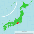 静岡県English: Shizuoka Pref.עברית : מחוז שיזוקה
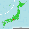 愛知県English: Aichi Pref.עברית : מחוז אייצ'י
 三重県English: Mie Pref.עברית : מחוז מיה
 滋賀県English: Shiga Pref.עברית : מחוז שיגה
 京都府English: Kyoto Pref.עברית : מחוז קיוטו
 大阪府English: Osaka Pref.עברית : מחוז אוסקה
 兵庫県English: Hyogo Pref.עברית : מחוז היוגו
 奈良県English: Nara Pref.עברית : מחוז נארה
 和歌山県English: Wakayama Pref.עברית : מחוז וואקאימה
 鳥取県English: Tottori Pref.עברית : מחוז טוטורי
 島根県English: Shimane Pref.עברית : מחוז שימאנה
 岡山県English: Okayama Pref.עברית : מחוז אוקאימה
 広島県English: Hiroshima Pref.עברית : מחוז הירושימה
 山口県English: Yamaguchi Pref.עברית : מחוז יאמגוצ'י
 愛媛県English: Ehime Pref.עברית : מחוז אהימה
 福岡県English: Fukuoka Pref.עברית : מחוז פוקוקה
 長崎県English: Nagasaki Pref.עברית : מחוז נגסקי
 熊本県English: Kumamoto Pref.עברית : מחוז קומאמוטו
 大分県English: Oita Pref.עברית : מחוז אויטה
 宮崎県English: Miyazaki Pref.עברית : מחוז מיאזאקי
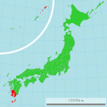 鹿児島県English: Kagoshima Pref.עברית : מחוז קגושימה
 沖縄県English: Okinawa Pref.עברית : מחוז אוקינאווה


.jpg)


