| |
|
Atlas-country
|
Equatorial Guinea
|
|
|
|
|
|
|
|
Guinea Ecuatorial
Guinée équatoriale
|
|
|
|
| Español
|
Guinea Ecuatorial - República de Guinea Ecuatorial
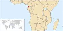
La República de Guinea Ecuatorial es un país del África central, y uno de los países más pequeños del África continental. Limita con Camerún al norte, Gabón al sur y el Golfo de Guinea al oeste, donde las islas de Santo Tomé y Príncipe se ubican al suroeste. Antiguamente fue una colonia española conocida como Guinea Española, y obtuvo su independencia el 12 de octubre de 1968. El territorio del país (conocido continentalmente como "Río Muni" o "Mbini") incluye un gran número de islas, entre las que se encuentran la isla de Bioko, donde se ubica la capital, Malabo (llamada antiguamente Santa Isabel). El nombre que adoptó el país tras obtener su independencia se debe a la cercanía con el Ecuador y a estar situado en el golfo de Guinea.
|
| Français
|
Guinée équatoriale - République de Guinée équatoriale
La République de Guinée équatoriale (ou Guinée-Équatoriale) est un pays d'Afrique centrale. Elle est constituée de deux parties. L'une continentale, bordée par le Cameroun et le Gabon, l'autre insulaire avec la capitale Malabo.
|
| Português
|
Guiné Equatorial - República da Guiné Equatorial
A República da Guiné Equatorial é um país no oeste da África Central, um dos menores no continente africano. Faz fronteira com Camarões ao norte, com o Gabão ao sul e a leste, e com o Golfo da Guiné a oeste, onde se localizam as ilhas de São Tomé e Príncipe ao sudoeste. Ex-colônia espanhola, chamada Guiné Espanhola, o território do país (com a parte continental conhecida como Río Muni ou Mbini) inclui uma série de ilhas, incluindo a ilha de Bioko, onde está localizada a capital, Malabo (antiga Santa Isabel).
|
| English
|
Equatorial Guinea - Republic of Equatorial Guinea
The Republic of Equatorial Guinea is a country in West Middle Africa, one of the smallest in continental Africa. It is bordered by ► Cameroon on the north, ► Gabon on the south and east, and the Gulf of Guinea on the west, where the islands of ► São Tomé and Príncipe lie to its southwest. Formerly the Spanish colony of Spanish Guinea, the country's territory (continentally known as Río Muni) includes a number of islands, including the sizable island of Bioko where the capital, Malabo (formerly Santa Isabel), is located.
|
|
|
|
| Short name
|
Equatorial Guinea
|
| Official name
|
Republic of Equatorial Guinea
|
| Status
|
Independent country since 1968
|
| Location
|
Central Africa
|
| Capital
|
Malabo
|
| Population
|
1,358,276 inhabitants
|
| Area
|
28,051 square kilometres (10,831 sq mi)
|
| Major languages
|
Spanish, French, Portuguese (all official), Pidgin English, Fang, Bubi, Ibo, Annobonese.
|
| Major religions
|
Roman Catholicism
|
| More information
|
Equatorial Guinea, Geography of Equatorial Guinea, History of Equatorial Guinea and Politics of Equatorial Guinea
|
| More images
|
Equatorial Guinea - Equatorial Guinea (Category).
|
|


 El mismo mapa en español


.jpg)

_Golfo_de_Guinea.jpg)
_Isla_de_Fernado_Poo.jpg)
