Suomen tasavalta eli Suomi on valtio Pohjois-Euroopassa Itämeren rannalla. Se rajautuu idässä Venäjään, pohjoisessa Norjaan ja lännessä Ruotsiin; neljäs naapurimaa Viro sijaitsee Suomenlahden eteläpuolella. Suomessa on 5 528 008 kansalaista (kesäkuu 2020), joten maan väestötiheys on suhteellisen alhainen. Suomi kuuluu Pohjoismaihin ja Euroopan unioniin.
Republiken Finland är en republik i norra Europa. Finland är sedan 1995 medlem i Europeiska unionen och det enda nordiska land som har infört euro som sin valuta. Det svenskspråkiga Åland (finska Ahvenanmaa) utgör ett självstyrande landskap inom landet. Finland är tvåspråkigt och finska och svenska har samma status i landet.
The Republic of Finland is one of the Nordic countries and a member of the European Union. Situated in Northern Europe, it shares land borders with ► Sweden to the west, ► Russia with ► Karelia to the east and ► Norway to the north while ► Estonia lies to its south. Finland is bounded by the Baltic Sea with the Gulf of Finland to the south and the Gulf of Bothnia to the west. The ► Åland Islands, off the south-western coast, are an autonomous province of Finland.
Short name
Finland
Official name
Republic of Finland
Status
Independent country since 1917, recognized 1918. Member of the ► European Union since 1995
Administrative divisions of Finland: Finland was 1997-2009 divided in 6 provinces (lääni/län), further divided in 20 regions (maakunta/landskap). Earlier the provinces were 11.
Administrativ uppdelning av Finland: Finland är uppdelat i sex län, och vidare indelat i 20 landskap
Finnish tribes did not develop a centralised state. From the twelfth century onwards the area of modern Finland was increasingly incorporated into Sweden. Sweden establishes in 1581 the Grand Duchy of Finland, subject to, and from 1772 in nominal personal union with, Sweden. This map shows Sweden during the Viking Age
Sverige under vikingatiden
Sweden in 1280 (Incorrect. The colonialization of Lappland (inner northern Sweden) did not start until 1670, and Norrbotten coast until some time after 1330. Hälsingland had a loose connection to Sweden until 1331.)
Finland before independence as part of the Russian Empire
Finland före självständigheten som en del av det Ryska kejsardömet
The Russian Empire in 1914 including Finland
Ryssland inklusive Finland, 1914
History of the Russian Empire (in German), Finland as part of Russia
Numbered Map of the historical provinces of Finland
During World War I, in 1917, Finland declares its independence. This independence is recognized by the new communist leaders of Russia. At the same time, the breach between left wing and and right wing armed groups becomes hostile. In 1918 the Finnish Civil War between Finnish communists and anti-communists starts. This map shows the initial frontlines and first offensives of the Finnish Civil War at the beginning of February
The main offensives to the end of March. Whites besiege Tampere and encircle attacking Soviet Russian and Red forces at Rautu, on Karelian Isthmus
The war ends in the victory of the anti-communists under general Carl Gustaf Emil Mannerheim in 1918. This map shows the 20.000 soldiers strong German intervention (grey) and final offensives of the War
During World War II, Finland fights the USSR twice: the first time in the Winter War of 1939-1940 (with some support from Sweden).
Finska vinterkriget
Map of Mannerheim line, the main defense line along the Karelian Isthmus in Winter War.
Treaty of Tartu
Finland cedes some border areas to the USSR according to the Moscow Peace Treaty
Moscow Peace Treaty
The second war is the Continuation War of 1941-1944 (with considerable support from Germany).
Second phase of the war 1941
Largest area controlled by Finland during Continuation War in about 1942
Administrative divisions of Finland in 1942-1944
German withdrawal in 1944 and 1945
Ceded areas in 1944
Seceded territory of Petsamo after WW II
Finland pre WW II border. After the war Finland is in the grey zone between western countries and the Soviet Union. Finland assumes a policy of cautious neutrality and "realpolitik", taking carefully into account Finland's geographical location next to the USSR.
Old maps
This section holds copies of original general maps more than 70 years old.
Sweden en Norway in 1595
Sverige och Norge år 1595
Grand Duchy of Finland 1662
Sweden and Finland in 1747
Grand Duchy of Finland in 1900
Storfurstendömet Finland år 1900
Municipalities
Linguistic maps
Location of Swedish-speaking an bilingual cities and municipalties of Finland
Dark blue: unlingually Swedish
Middle blue: bilingual with Swedish as majority language
Light blue: bilingual with Finnish as majority language
White: unilingually Finnish
Swedish speakers in Finnish map of municipalities. Municipalities with more than 460 inhabitants, who speak Swedish as mother tongue including immigrants, according to records on December 31st 2003, are coloured red.
Svenska dialekter
Swedish dialects
Samiska språk
Sami languages
Ethnic map of European Russia before the First World War, including Finland (in French)
Satellite maps
Satellite map
Satellitkarta
Satellite map in winter
Satellitkarta, vintertid
Notes and references
General remarks:
The WIKIMEDIA COMMONS Atlas of the World is an organized and commented collection of geographical, political and historical maps available at Wikimedia Commons. The main page is therefore the portal to maps and cartography on Wikimedia. That page contains links to entries by country, continent and by topic as well as general notes and references.
Every entry has an introduction section in English. If other languages are native and/or official in an entity, introductions in other languages are added in separate sections. The text of the introduction(s) is based on the content of the Wikipedia encyclopedia. For sources of the introduction see therefore the Wikipedia entries linked to. The same goes for the texts in the history sections.
Historical maps are included in the continent, country and dependency entries.
The status of various entities is disputed. See the content for the entities concerned.
The maps of former countries that are more or less continued by a present-day country or had a territory included in only one or two countries are included in the atlas of the present-day country. For example the Ottoman Empire can be found in the Atlas of Turkey.


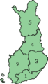 Map of Finland with provinces
 Province of Eastern Finland (Itä-Suomen lääni)
 Province of Lapland (Lapin lääni)
 Province of Oulu (Oulun lääni)
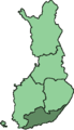 Province of Southern Finland (Etelä-Suomen lääni)
 Province of Western Finland (Länsi-Suomen lääni)
.png)


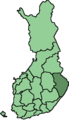
 Etelä-Karjala (South Karelia)
 Etelä-Pohjanmaa (Southern Ostrobothnia)
 Etelä-Savo (Southern Savonia)
 Itä-Uusimaa (Eastern Uusimaa)
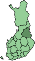 Kainuu
 Kanta-Häme (Tavastia Proper)
 Keski-Pohjanmaa (Central Ostrobothnia)
 Keski-Suomi (Central Finland)
 Kymenlaakso
 Lappi (Lapland)
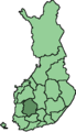 Pirkanmaa
 Pohjois-Karjala (North Karelia)
 Pohjois-Pohjanmaa (Northern Ostrobothnia)
 Pohjois-Savo (Northern Savonia)
 Päijät-Häme (Päijänne Tavastia)
 Satakunta
 Uusimaa
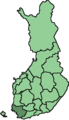 Varsinais-Suomi (Finland Proper)
 Åland (Ahvenanmaa)


