|
Atlas of Asia
|
|
|
Asia
|
| English
|
Asia
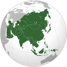
Asia is the largest and most populous continent or region, depending on the definition. It covers 8.6% of the Earth's total surface area, or 29.4% of its land area, and it contains more than 60% of the world's human population. Asia is traditionally defined as part of the landmass of Africa-Eurasia – with the western portion of the latter occupied by ► Europe – lying east of the Suez Canal, east of the Ural Mountains, and south of the Caucasus Mountains and the Caspian and Black Seas.
|
| 中文
|
亚洲
亚细亚洲(英語:Asia;字源古希腊文:Ασία ),简称亚洲,大部分土地位于北半球,是七大洲中面积最大,人口最多的一个洲。大陆东至白令海峡的杰日尼奥夫角(西经169度40分,北纬60度5分),南至努沙登加拉群岛(东经103度30分,南纬11度7分),西至巴巴角(东经26度3分,北纬39度27分),北至切柳斯金角(东经104度18分,北纬77度43分),最高峰为珠穆朗瑪峰。跨越经纬度十分广,东西时差达11小时。西部与欧洲相连,形成地球上最大的陆块欧亚大陆。
|
| हिन्दी
|
जंबुद्वीप
जम्बुद्वीप (जंबुमहाद्वीप, या एशिया) विश्व का क्षेत्रफल और जनसंख्या दोनो के हिसाब से सबसे बड़ा महाद्वीप है । भौगोलिक रूप से ये यूरेशिया महाखंड का पूर्वी हिस्सा है । यानि कि यूरोप और जंबूद्वीप में फ़र्क सिर्फ एतिहासिक और सांस्कृतिक है ।
|
| Bahasa Indonesia
|
Asia
Benua Asia merupakan wilayah yang mencakup daratan luas Afrika-Eurasia tanpa Eropa dan Afrika. Batas antara Asia dan Eropa sangat kabur, yakni berasa di wilayah Dardanella, Laut Marmara, selat Bosforus, Laut Hitam, pegunungan Kaukasus, Laut Kaspia, Sungai Ural (atau Sungai Emba), dan Pegunungan Ural hingga Novaya Zemlya, sedangkan dengan Afrika, Asia bertemu di sekitar Terusan Suez. Sekitar 60% populasi dunia tinggal di Asia. Lihat pula Eurasia.
|
| العربية
|
آسيا
تعتبر آسيا أكبر القارات من حيث المساحة والسكان، فتشمل 30% من اليابسة، ويعيش عليها تقريب ثلاثة أخماس سكان العالم، وتقع تقريبا في نصف الكرة الشمالي . يحدها شمالا المحيط القطبي الشمالي وبشرقه ممر بيرنج الجليدي. وفي الجنوب المحيط الهندي وبالغرب البحرين الأحمر والأبيض المتوسط. وشمال غرب تقع حدودها مع أوروبا. آسيا متصلة مع اوروبا بحيث انه يمكن اعتبراهما قارة واحدة ولكنهما تعتبران قارتين لاسباب تاريخية، وتعتبر جبال الاورال ونهر الاورال الفاصل بينهما. ترتبط مع افريقيا بشبه جزيرة سيناء وتعتبر قناة السويس الخط الفاصل بينهما. يقطن آسيا اكبر عدد من السكان مقارنة بالقارات الأخرى وفيها اكبر تجمعيين سكانيين في دول وهما الصين (1.3 بليون نسمة) والهند (1.1 بليون نسمة)، كما أن بها أكبر دول العالم وأصغرها مساحة روسيا و هي اكبر دولة عالمية من حيث المساحة بحث تغطي مساحة قدرها 17 مليون كيلومتر مريع، وهنا أصغر الدول مثل البحرين، المالديف، وسنغافورة مساحة كل منها أقل من 780 كيلومتر مربع. أكثر من خمسي بلاد آسيا بها سكان أقل من 6 مليون نسمة. قامت بها أكبر عدد من الحضارات القديمة كحضارات الهند وبابل وسومر وآشور والفرس والصين. وحضارة الفنيقيين والحيثيين والحضارة الإسلامية.
|
| 日本語
|
アジア
アジア(亜細亜、'Asia)は、古代においては、現在のトルコ西部の地域にあたる古代ローマの属州アジアとその一帯を指す。アッシリア語で東を意味する「アス」に語源をもつ。また、略称は亜である。現在ではユーラシア大陸のヨーロッパ以外の地域(ユーラシア大陸の中・東部、アジア大陸)およびその周辺の島嶼・海域を含む地域の総称で、六大州の一つ。ユーラシア大陸の面積の約80%をアジアが占める。
|
| 한국어
|
아시아
아시아는 정의에 따라 가장 크고 가장 인구가 많은 대륙이나 지역입니다. 지구 전체 표면적의 8.6%, 즉 국토 면적의 29.4%를 차지하고 있으며, 전 세계 인구의 60% 이상을 차지하고 있습니다. 아시아는 전통적으로 아프리카-유라시아 영토의 일부로 간주되며, 유럽이 차지하는 아시아의 서쪽 부분은 수에즈 운하와 우랄 산맥의 동쪽, 코카서스 산맥과 카스피해 그리고 흑해의 남쪽에 위치합니다.
|
| Population
|
3,902,404,193 inhabitants
|
| Area
|
43,810,582 km²
|
| Major language(s)
|
Chinese, Hindi, Indonesian, Arabic, Bengali, Japanese, etc.
|
| Major religion(s)
|
Hinduism, Buddhism, Islam
|
| More information
|
Asia, Geography of Asia, History of Asia and Politics of Asia
|
| More images
|
Asia - Asia (Category).
|
|

.svg)


