Belize, formerly known as British Honduras, is a small nation on the eastern coast of Central America on the Caribbean Sea bordered by ► Mexico to the northwest and ► Guatemala to the west and south. The country is a parliamentary democracy and constitutional monarchy which recognizes Queen Elizabeth II as Sovereign. The name is shared by the Belize River, Belize's longest river, and Belize City, the former capital and largest city.
Short name
Belize
Official name
Belize
Status
Independent country since 1981
Location
Central America
Capital
Belmopan
Population
408,487 inhabitants
Area
22,966 square kilometres (8,867 sq mi)
Major languages
English (official), Spanish, Belizean Creole, German, Garifuna, Mayan Languages
Major religions
Roman Catholicism, Protestantism, and Mayan religions
This section holds a short summary of the history of the area of present-day Belize, illustrated with maps, including historical maps of former countries and empires that included present-day Belize.
Present-day Belize was for a long time part of the Maya Empire. The Maya civilization flourished until about 1200.
This map shows the Maya civilization compared with present states.
European contact began in 1502 when Christopher Columbus sails along the coast. The first recorded European settlement was begun by shipwrecked English seamen in 1638. Over the next 150 years, more English settlements are established. The area becomes formally a British colony as British Honduras in 1840. In 1862 British Honduras becomes administrative part of Jamaica, which it remains until 1884. Between 1954 and 1959 British Honduras has internal self-government. Between 1959 and 1961 the colony is under direct administration of the British government. In 1964 British Honduras achieves full internal self-government. Nine year later, in 1973, the colony is renamed Belize.
In 1981 Belize becomes an independent parliamentary democratic monarchy.
Old maps
This section holds copies of original general maps more than 70 years old.
Map of British territory in the Yucatan from 1787
Map of British territory in the Yucatan from 1790
Map of British territory in the Yucatan from 1840
Map of British territory in the Yucatan from 1855
Map of British Honduras from 1864
Map of British Honduras from 1888
Other maps
Maya languages
Map of British Honduras from 1965
Satellite maps
Satellite image from 2002
Notes and references
General remarks:
The WIKIMEDIA COMMONS Atlas of the World is an organized and commented collection of geographical, political and historical maps available at Wikimedia Commons. The main page is therefore the portal to maps and cartography on Wikimedia. That page contains links to entries by country, continent and by topic as well as general notes and references.
Every entry has an introduction section in English. If other languages are native and/or official in an entity, introductions in other languages are added in separate sections. The text of the introduction(s) is based on the content of the Wikipedia encyclopedia. For sources of the introduction see therefore the Wikipedia entries linked to. The same goes for the texts in the history sections.
Historical maps are included in the continent, country and dependency entries.
The status of various entities is disputed. See the content for the entities concerned.
The maps of former countries that are more or less continued by a present-day country or had a territory included in only one or two countries are included in the atlas of the present-day country. For example the Ottoman Empire can be found in the Atlas of Turkey.


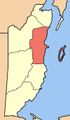 District Belize
 District Cayo
 District Corozal
 District Orange Walk
 District Stann Creek
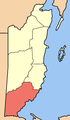 District Toledo


.jpg)


