La República del Ecuador es un país que se encuentra ubicado al noroeste de América del Sur y cuyos límites territoriales son: al norte con Colombia, al sur y al este con Perú y al oeste con el Océano Pacífico. Obtuvo su independencia de España en 1822, pasando a formar parte de la Gran Colombia junto con Colombia, Venezuela y Panamá hasta su separación de la misma en 1830. Este país está atravesado por la línea ecuatorial o Ecuador terrestre que da origen a su nombre. Ocupa una superficie de 283 560 km² en los que se incluye el archipiélago de las Islas Galápagos situado a unos 1.000 km del territorio continental. Ecuador cuenta con 13 millones 710 mil habitantes (2005). Su capital política y administrativa es San Francisco de Quito, y la ciudad más poblada del país es la ciudad de Santiago de Guayaquil, uno de los puertos más importantes de América del Sur. Este país se divide administrativamente en 22 provincias, todas continentales salvo una que está formada exclusivamente por las Islas Galápagos.
The Republic of Ecuador is a representative democratic republic in South America, bounded by ► Colombia on the north, by ► Peru on the east and south, and by the Pacific Ocean on the west. The country also includes the ► Galápagos Islands (Archipiélago de Colón) in the Pacific, about 965 kilometers (600 miles) west of the mainland. Ecuador is the Spanish word for equator. Ecuador straddles the equator and has an area of 256,370 square kilometers (98,985 mi²). Its capital city is Quito, however its largest city is Guayaquil.
Compare: 104 Soil Maps in Ecuador : Schematic Vegetation Map of Ecuador, Mapa General de las Asociaciaciones de Suelos en el Ecuador, Ecological Map, etc.
History maps
This section holds a short summary of the history of the area of present-day Ecuador, illustrated with maps, including historical maps of former countries and empires that included present-day Ecuador.
The WIKIMEDIA COMMONS Atlas of the World is an organized and commented collection of geographical, political and historical maps available at Wikimedia Commons. The main page is therefore the portal to maps and cartography on Wikimedia. That page contains links to entries by country, continent and by topic as well as general notes and references.
Every entry has an introduction section in English. If other languages are native and/or official in an entity, introductions in other languages are added in separate sections. The text of the introduction(s) is based on the content of the Wikipedia encyclopedia. For sources of the introduction see therefore the Wikipedia entries linked to. The same goes for the texts in the history sections.
Historical maps are included in the continent, country and dependency entries.
The status of various entities is disputed. See the content for the entities concerned.
The maps of former countries that are more or less continued by a present-day country or had a territory included in only one or two countries are included in the atlas of the present-day country. For example the Ottoman Empire can be found in the Atlas of Turkey.


 Azuay Province
 Bolívar Province
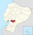 Cañar Province
 Carchi Province
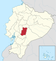 Chimborazo Province
 Cotopaxi Province
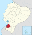 El Oro Province
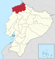 Esmeraldas Province
 Galápagos Province
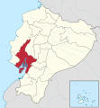 Guayas Province
 Imbabura Province
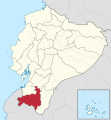 Loja Province
 Los Ríos Province
 Manabí Province
 Morona-Santiago Province
 Napo Province
 Orellana Province
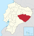 Pastaza Province
 Pichincha Province
 Santa Elena Province
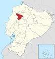 Santo Domigo de los Tsáchilas Province
 Tungurahua Province
 Zamora-Chinchipe Province
.svg)
.svg)
.svg)
.svg)
.svg)
.svg)
.svg)
.svg)
.svg)
.svg)
.svg)
.svg)
.svg)
.svg)
.svg)
.svg)
.svg)
.svg)
.svg)
.svg)
.svg)
.svg)
.svg)


.svg)


