Atlas of South America

From Wikimedia Commons, the free media repository

Jump to: navigation, search
Atlas • Άτλας • Атлас • Atlante • Atlasas • אטלס • جهان‌نما • أطلس • एटलस • 地図帳 • 地圖集
WIKIMEDIA COMMONS Atlas of the World

Discuss • Update the atlas • Content and Index of the Atlas • Atlas in categories • Other atlases on line

The introductions of the country, dependency and region entries are in the native languages and in English. The other introductions are in English.

Chile Peru Argentina Uruguay Brazil Paraguay Bolivia Ecuador Columbia Venezuela Trinidad and Tobago Guyana Suriname French Guiana Panama Costa Rica Nicaragua
About this image
Atlas of South America
South America
English South America
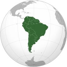
South America is a continent situated in the western hemisphere and, mostly, the southern hemisphere, bordered on the west by the Pacific Ocean and on the north and east by the Atlantic Ocean; North America and the Caribbean Sea lie to the northwest. As part of the Americas like North America, South America is named after Amerigo Vespucci, who was the first European to suggest that the Americas were not the East Indies, but a New World unknown to Europeans. South America has an area of 17,840,000 km² (6,890,000 sq mi), or almost 3.5% of the Earth's surface. As of 2005, its population was estimated at more than 371,000,000. South America ranks fourth in area (after Asia, Africa, and North America) and fifth in population (after Asia, Africa, Europe, and North America).
Español América del Sur, también llamado Sudamérica o Suramérica, es un subcontinente atravesado por la línea ecuatorial, con la mayor parte de su área en el Hemisferio Sur. Está situado entre el Océano Pacífico y el Océano Atlántico. Alternativamente, en algunos países de habla no hispana se considera un continente.
Português A América do Sul é um subcontinente que compreende a porção meridional das Américas. Sua extensão é de 17.819.100 km², abrangendo 12% da superfície terrestre, porém só tem 6% da população mundial. Une-se a América Central, ao norte, pelo istmo/canal do Panamá. Tem uma extensão de 7.400 km desde o mar do Caribe até o cabo de Hornos.
Population 371,000,000 inhabitants
Area 17,840,000 km²
Major language(s) Spanish, Portuguese
Major religion(s) Roman Catholicism
More information South America, Geography of South America, History of South America and Politics of South America
More images South America - South America (Category).

General maps

Location of the Americas
Map of the Americas
Map of the Americas
Map of South America
Countries of South America
Political map with 1st level divisions as of 1998 in SVG format

History maps

This section holds a short summary of the history of the area of present-day South America, illustrated with maps, including historical maps of former countries and empires that included present-day South America.

Voyages of Christoper Columbus
Colonization of the Americas
Spanish colonization
Spanish and Portuguese colonization of the Americas
Countries in the Americas by date of independence

Old maps

This section holds copies of original general maps older than 70 years of this entry.

First map to show the name America
Piri Reis map
South America 1575
Map of the Americas 1587 (Ortelius)
Map of the Americas 1637 (Hondius)
Map of the Americas 1705
Map of the Americas 1722
South America 1750
Map of the Americas 1770
South America 1790
South America 1794
South America 1885
South America 1892
South America 1905
South America 1914

Maps of international organizations

Organization of American States
South American Community of Nations
Mercosur
Mercosur
Mercosur
GNU head Permission is granted to copy, distribute and/or modify this document under the terms of the GNU Free Documentation license, Version 1.2 or any later version published by the Free Software Foundation; with no Invariant Sections, no Front-Cover Texts, and no Back-Cover Texts. A copy of the license is included in the section entitled "GNU Free Documentation license".

Aragonés | العربية | Asturianu | Беларуская (тарашкевіца) | Български | বাংলা | ইমার ঠার/বিষ্ণুপ্রিয়া মণিপুরী | Brezhoneg | Bosanski | Català | Cebuano | Česky | Dansk | Deutsch | Ελληνικά | English | Esperanto | Español | Eesti | Euskara | فارسی | Suomi | Français | Gaeilge | Galego | עברית | Hrvatski | Magyar | Bahasa Indonesia | Ido | Íslenska | Italiano | 日本語 | ქართული | ភាសាខ្មែរ | 한국어 | Kurdî / كوردی | Latina | Lëtzebuergesch | Lietuvių | Bahasa Melayu | Nnapulitano | Nederlands | ‪Norsk (nynorsk)‬ | ‪Norsk (bokmål)‬ | Occitan | Polski | Português | Română | Русский | Slovenčina | Slovenščina | Shqip | Српски / Srpski | Svenska | తెలుగు | ไทย | Tagalog | Türkçe | Українська | اردو | Tiếng Việt | Volapük | Yorùbá | ‪中文(简体)‬ | ‪中文(繁體)‬ | +/-

Andean Community of Nations
Rio Group
Asia-Pacific Economic Cooperation

Ethnic maps

Indian population of the Americas

Satellite maps

Satellite map

Notes and references

General remarks:

  • The WIKIMEDIA COMMONS Atlas of the World is an organized and commented collection of geographical, political and historical maps available at Wikimedia Commons. The main page is therefore the portal to maps and cartography on Wikimedia. That page contains links to entries by country, continent and by topic as well as general notes and references.
  • Every entry has an introduction section in English. If other languages are native and/or official in an entity, introductions in other languages are added in separate sections. The text of the introduction(s) is based on the content of the Wikipedia encyclopedia. For sources of the introduction see therefore the Wikipedia entries linked to. The same goes for the texts in the history sections.
  • Historical maps are included in the continent, country and dependency entries.
  • For Burma, see Myanmar; Great Britain and Northern Ireland, see United Kingdom; Ivory Coast, see Côte d'Ivoire; Pridnestrovie, see Transnistria; Taiwan, see China, Republic of; Timor-Leste, see East Timor.
  • The status of various entities is disputed. See the content for the entities concerned.
  • The maps of former countries that are more or less continued by a present-day country or had a territory included in only one or two countries are included in the atlas of the present-day country. For example the Ottoman Empire can be found in the Atlas of Turkey.

Entries available in the atlas

General pages
Atlas · Historical atlas · Index of the Atlas · Names in native languages

The world and its continents and oceans
General maps of the world · Historical maps of the world · Old maps · Africa · North and South America · Antarctica · Asia · Europe (History, European Union) · Oceania · Oceans

Historical era and themes
Prehistory · Antiquity · Middle Ages · Rise of Islam · Early Modern Age · Early American Societies · Early Asian Societies · Age of Renaissance · Colonialism · 20th Century · World War I · World War II

Countries with undisputed status
Afghanistan · Albania · Algeria · Andorra · Angola · Antigua and Barbuda · Argentina · Armenia · Australia · Austria · Azerbaijan · Bahamas · Bahrain · Bangladesh · Barbados · Belarus · Belgium · Belize · Benin · Bhutan · Bolivia · Bosnia and Herzegovina · Botswana · Brazil · Brunei · Bulgaria · Burkina Faso · Burundi · Cambodia · Cameroon · Canada · Cape Verde · Central African Republic · Chad · Chile · China · Colombia · Comoros · Congo (Democratic Republic) · Congo (Republic) · Costa Rica · Côte d’Ivoire · Croatia · Cuba · Cyprus · Czech Republic · Denmark · Djibouti · Dominica · Dominican Republic · East Timor · Ecuador · Egypt · El Salvador · Equatorial Guinea · Eritrea · Estonia · Ethiopia · Fiji · Finland · France · Gabon · Gambia · Georgia · Germany · Ghana · Greece · Grenada · Guatemala · Guinea · Guinea-Bissau · Guyana · Haiti · Honduras · Hungary · Iceland · India · Indonesia · Iran · Iraq · Ireland · Israel · Italy · Jamaica · Japan · Jordan · Kazakhstan · Kenya · Kiribati · Korea (Democratic People’s Republic) · Korea (Republic) · Kuwait · Kyrgyzstan · Laos · Latvia · Lebanon · Lesotho · Liberia · Libya · Liechtenstein · Lithuania · Luxembourg · Macedonia (Republic) · Madagascar · Malawi · Malaysia · Maldives · Mali · Malta · Marshall Islands · Mauritania · Mauritius · Mexico · Micronesia (Federated States) · Moldova · Monaco · Mongolia · Montenegro · Morocco · Mozambique · Myanmar · Namibia · Nauru · Nepal · The Netherlands · New Zealand · Nicaragua · Niger · Nigeria · Norway · Oman · Pakistan · Palau · Panama · Papua New Guinea · Paraguay · Peru · Philippines · Poland · Portugal · Qatar · Romania · Russia · Rwanda · Saint Kitts and Nevis · Saint Lucia · Saint Vincent and the Grenadines · Samoa · San Marino · São Tomé and Príncipe · Saudi Arabia · Senegal · Serbia · Seychelles · Sierra Leone · Singapore · Slovakia · Slovenia · Solomon Islands · Somalia · South Africa · Spain · Sri Lanka · Sudan · Suriname · Swaziland · Sweden · Switzerland · Syria · Tajikistan · Tanzania · Thailand · Togo · Tonga · Trinidad and Tobago · Tunisia · Turkey · Turkmenistan · Tuvalu · Uganda · Ukraine · United Arab Emirates · United Kingdom · United States · Uruguay · Uzbekistan · Vanuatu · Vatican City · Venezuela · Vietnam · Yemen · Zambia · Zimbabwe

Countries with disputed status
Abkhazia · China (Republic)/Taiwan · Kosovo · Nagorno-Karabakh · Northern Cyprus · Palestine · Somaliland · South Ossetia · Tamil Eelam · Transnistria · Western Sahara

Dependencies and other overseas territories
Akrotiri and Dhekelia · Åland · American Samoa · Anguilla · Aruba · Ascension Island · Ashmore and Cartier Islands · Baker Island · Bermuda · Bouvet Island · British Indian Ocean Territory · British Virgin Islands · Cayman Islands · Christmas Island · Clipperton Island · Cocos (Keeling) Islands · Cook Islands · Coral Sea Islands · Falkland Islands · Faroe Islands · French Guiana · French Polynesia · French Southern and Antarctic Lands · Gibraltar · Greenland · Guadeloupe · Guam · Guantanamo Bay · Guernsey · Heard Island and McDonald Islands · Hong Kong · Howland Island · Isle of Man · Jan Mayen · Jarvis Island · Jersey · Johnston Atoll · Kingman Reef · Macau · Martinique · Mayotte · Midway Atoll · Montserrat · Navassa Island · Netherlands Antilles · New Caledonia · Niue · Norfolk Island · Northern Mariana Islands · Palmyra Atoll · Pitcairn Islands · Puerto Rico · Réunion · Saint Helena · Saint-Barthélemy · Saint Martin (France) · Saint-Pierre and Miquelon · South Georgia and South Sandwich Islands · Svalbard · Tokelau · Tristan da Cunha · Turks and Caicos Islands · United States Virgin Islands · Wake Island · Wallis and Futuna

Disputed areas
Kashmir · Paracel Islands · Spratly Islands

Subnational autonomous entities
Aceh · Adjara · Adygea · Altai · Andalusia · Aosta Valley · Aragon · Athos · Azores · Balearic Islands · Bashkortostan · Basque Country · Bougainville · Brussels · Buryatia · Canary Islands · Catalonia · Chechnya · Chivasia · Corsica · Crimea · Curaçao · Dagestan · Easter Island · England · Extremadura · Bosnia and Herzegovina (Federation · Flanders · Friuli-Venezia Giulia · Gagauzia · Galicia · Galápagos Islands · Gorno-Basakhshan · Guanxi · Ingushetia · Inner Mongolia · Kabadino-Balkaria · Kalmykia · Karachay-Cherkessia · Karakalpakstan · Karelia · Khakassia · Komi · Kurdistan (Iraqi) · Madeira · Mari El · Mindanao · Mordovia · Nakhchivan · Navarre · Nevis · Ningxia · North Ossetuia-Alania · Northern Ireland · Quebec · Saint Martin (Netherlands) · Sakha · Sardinia · Scotland · Sicily · Srpska · Tatarstan · Tibet · Trentino-Alto Adige · Tuva · Udmurtia · Vojvodina · Wales · Wallonia · Xinjiang · Zanzibar

Other regions
Burzenland · Kurdistan · Sápmi

Former countries
Austria-Hungary · Byzantine Empire · Caliphate · Czechoslovakia · Frankish Empire · Inca Empire · Macedonian Empire · Prussia · Roman Empire · Soviet Union · Yugoslavia

Themes
Administrative divisions · International organizations · Languages · Religions

Old atlas
Stielers Handatlas 1891

Personal tools