La République du Cameroun est un pays d'Afrique centrale situé entre le Nigeria, le Tchad, la République centrafricaine, le Gabon, la Guinée équatoriale, la République du Congo et le golfe de Guinée. Une partie du territoire sous tutelle britannique (Cameroons) et l'ancien territoire sous tutelle française (qui accéda à l’indépendance sous l’appellation de République du Cameroun le 1er janvier 1960) ont fusionné en 1961 pour former la République fédérale du Cameroun, qui le 20 mai 1972 fut renommée République unie du Cameroun ; depuis 1984 le pays s'appelle la République du Cameroun.
04. Location of the Extreme North Province in Cameroon
05. Location of the Littoral Province in Cameroon
06. Location of the North Province in Cameroon
07. Location of the Northwest Province in Cameroon
08. Location of the West Province in Cameroon
09. Location of the South Province in Cameroon
10. Location of the Southwest Province in Cameroon
Adamawa divisions
East divisions
Far North divisions
Littoral divisions
North divisions
Northwest divisions
West divisions
South divisions
Southwest divisions
Centre divisions
History maps
This section holds a short summary of the history of the area of present-day Cameroon, illustrated with maps, including historical maps of former countries and empires that included present-day Cameroon.
The earliest inhabitants of present-day Cameroon are probably the Bakas (Pygmies). They still inhabit the forests of the south and east provinces. Bantu speakers originating in the Cameroonian highlands are among the first groups to move out before other invaders. Around 1472 the coast of what is now Cameroon is explored by Fernão do Pó. He names the area Rio dos Camaroes. During the late 1770s and early 1800s, the Fulani, a pastoral Islamic people of the western Sahel, conquer most of what is now northern Cameroon, subjugating or displacing its largely non-Muslim inhabitants.
In the nineteenth century both Britain and France are interested in the area, but it is Germany that establishes in 1884 the protectorate of Cameroon, in 1896 converted into a German crown land. This map shows the boundaries of the protectorate, compared with later borders.
In World War I France and the United Kingdom invade Cameroon (1914). After the war, in 1919, Cameroon is divided into French Cameroons and British Cameroons. In 1922 French Cameroons becomes a League of Nations mandate, converted into a United Nations Trust Territory in 1946. France grants Cameroons internal self-government in 1957. This map shows Cameroon as part of the French colonial empire.
Cameroon becomes independent as the Republic of Cameroon in 1960 and in 1961 it unites with the southern part of British Cameroons (Southern Cameroons) as the Federal Republic of Cameroon. In 1972 the country is renamed United Republic of Cameroon.
Provinces 1972-1983
Old maps
This section holds copies of original general maps more than 70 years old.
Karte von Camerun, Meyers Konversationslexikon von 1888
Other maps
Ethnic groups of Cameroon
Cameroon's Adamawa Province with territories of its ethnic groups indicated
Cameroon's Centre Province with territories of its ethnic groups indicated
Cameroon's East Province with territories of its ethnic groups indicated
Cameroon's Extreme North Province with territories of its ethnic groups indicated
Cameroon's North Province with territories of its ethnic groups indicated
Cameroon's South Province with territories of its ethnic groups indicated
Cameroon's West Province with territories of its ethnic groups indicated
Map showing the Duala ethnic groups of Cameroon
Map showing the Maka-Njem ethnic groups of Cameroon, CAR, Gabon, and Equatorial Guinea
Satellite maps
Satellite map
Notes and references
General remarks:
The WIKIMEDIA COMMONS Atlas of the World is an organized and commented collection of geographical, political and historical maps available at Wikimedia Commons. The main page is therefore the portal to maps and cartography on Wikimedia. That page contains links to entries by country, continent and by topic as well as general notes and references.
Every entry has an introduction section in English. If other languages are native and/or official in an entity, introductions in other languages are added in separate sections. The text of the introduction(s) is based on the content of the Wikipedia encyclopedia. For sources of the introduction see therefore the Wikipedia entries linked to. The same goes for the texts in the history sections.
Historical maps are included in the continent, country and dependency entries.
The status of various entities is disputed. See the content for the entities concerned.
The maps of former countries that are more or less continued by a present-day country or had a territory included in only one or two countries are included in the atlas of the present-day country. For example the Ottoman Empire can be found in the Atlas of Turkey.


 01. Location of the Adamawa Province in Cameroon
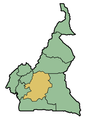 02. Location of the Centre Province in Cameroon
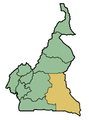 03. Location of the East Province in Cameroon
 04. Location of the Extreme North Province in Cameroon
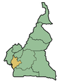 05. Location of the Littoral Province in Cameroon
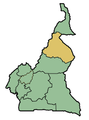 06. Location of the North Province in Cameroon
 07. Location of the Northwest Province in Cameroon
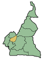 08. Location of the West Province in Cameroon
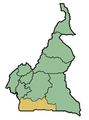 09. Location of the South Province in Cameroon
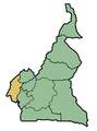 10. Location of the Southwest Province in Cameroon


 Adamawa divisions
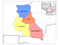 East divisions
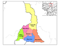 Far North divisions
 Littoral divisions
 North divisions
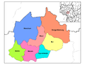 Northwest divisions
 West divisions
 South divisions
 Southwest divisions
 Centre divisions


 Cameroon's Adamawa Province with territories of its ethnic groups indicated
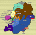 Cameroon's Centre Province with territories of its ethnic groups indicated
 Cameroon's East Province with territories of its ethnic groups indicated
 Cameroon's Extreme North Province with territories of its ethnic groups indicated
 Cameroon's North Province with territories of its ethnic groups indicated
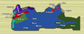 Cameroon's South Province with territories of its ethnic groups indicated
 Cameroon's West Province with territories of its ethnic groups indicated
 Map showing the Duala ethnic groups of Cameroon
 Map showing the Maka-Njem ethnic groups of Cameroon, CAR, Gabon, and Equatorial Guinea


