Sverige (officiellt Konungariket Sverige) är en konstitutionell monarki i norra Europa, beläget på östra delen av den skandinaviska halvön. Landet gränsar till Norge i väster, Finland i nordost, samt Danmark i sydväst via Öresundsbron. Landet har också maritima gränser till Estland, Lettland, Litauen, Polen, Tyskland samt Ryssland (Kaliningrad). De omgivande vattnen är Bottenviken och Bottenhavet som utgör en del av Östersjön, samt i sydväst Skagerrak, Kattegatt och Öresund.
Ruotsi on perustuslaillinen monarkia Skandinaviassa Pohjois-Euroopassa. Sillä on yhteinen raja Suomen ja Norjan kanssa. Ruotsi on Euroopan unionin jäsen ja pohjoismainen teollisuusmaa.
The Kingdom of Sweden is a Nordic country in Scandinavia. It is bordered by ► Norway in the west, ► Finland in the northeast, the Skagerrak Strait and the Kattegat Strait in the southwest, and the Baltic Sea and the Gulf of Bothnia in the east. It is connected to ► Denmark in the southwest by the Oresund Bridge.
Short name
Sweden
Official name
Kingdom of Sweden
Status
Independent country since the middle ages (1134), member of the ► European Union since 1995.
This section holds a short summary of the history of the area of present-day Sweden, illustrated with maps, including historical maps of former countries and empires that included present-day Sweden.
Map of the Swedish Empire from 1560 to 1815
A map of the area covered by the Pre-Roman Iron Age, 4th century BC - 1st century BC
Map showing Scandinavian settlement in the eight (dark red), ninth (red), tenth (orange) and eleventh (yellow) centuries. Areas denoted in green are those affected by frequent viking incursions, but with little or no Scandinavian settlement.
Sweden in 1020
Sverige år 1020
Sweden in the 12th century
Sverige på elvahundratalet
Scandinavia in 1219. The realms of Denmark, Norway, Sweden and the Sword Brethren
Sweden in 1280 (Incorrect. The colonization of Lappland (inner northern Sweden) did not start until 1670, and Norrbotten coast until some time after 1330. Hälsingland had a loose connection to Sweden until 1331.)
The Baltic provinces of the Swedish Empire in the 17th century. With English country names.
De svenska baltiska besittningarna under 1600-talet, med engelska lands- och ortsnamn.
The Baltic provinces of the Swedish Empire in the 17th century. With Swedish country names.
De svenska baltiska besittningarna under 1600-talet, med svenska lands- och ortsnamn.
The region after the Vienna congress
Norden efter Wienkongressen
Old maps
This section holds copies of original general maps more than 70 years old.
Map of Sweden (Scandinavia) from the 1st century Karta över Sverige från ca 150 e.kr.
Map of Sweden (Scandinavia) from the 16th century Karta över Sverige från 1500-talet
Map of Sweden from the 18th century Karta över Sverige från 1700-talet
Map of Norway and Sweden from the 19th century Karta över Norge och Sverige från 1800-talet
Map of Sweden and Norway in 1905 Karta över Sverige och Norge 1905
Other maps
GRP per capita per län, counted in thousands of Swedish crowns (2004).
Bruttoregionalprodukt per invånare i de svenska länen. Räknat i tusental svenska kronor.
Satellite maps
Satellite map Satellitbild över Sverige och Norden
Satellite map Satellitbild över Sverige
Satellite map Satellitbild över Sverige
Notes and references
General remarks:
The WIKIMEDIA COMMONS Atlas of the World is an organized and commented collection of geographical, political and historical maps available at Wikimedia Commons. The main page is therefore the portal to maps and cartography on Wikimedia. That page contains links to entries by country, continent and by topic as well as general notes and references.
Every entry has an introduction section in English. If other languages are native and/or official in an entity, introductions in other languages are added in separate sections. The text of the introduction(s) is based on the content of the Wikipedia encyclopedia. For sources of the introduction see therefore the Wikipedia entries linked to. The same goes for the texts in the history sections.
Historical maps are included in the continent, country and dependency entries.
The status of various entities is disputed. See the content for the entities concerned.
The maps of former countries that are more or less continued by a present-day country or had a territory included in only one or two countries are included in the atlas of the present-day country. For example the Ottoman Empire can be found in the Atlas of Turkey.


.svg)
_Sv.svg)


 Blekinge län
 Dalarnas län
 Gotlands län
 Gävleborgs län
 Hallands län
 Jämtlands län
 Jönköpings län
 Kalmar län
 Kronobergs län
 Norrbottens län
 Örebro län
 Östergötlands län
 Skåne län
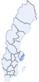 Stockholms län
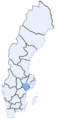 Södermanlands län
 Uppsala län
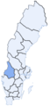 Värmlands län
 Västerbottens län
 Västernorrlands län
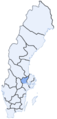 Västmanlands län
 Västra Götalands län


 Norrland
 Svealand
 Götaland
 Skåneland


.PNG)


_en2.png)


.jpg)